In my last week’s blog post, Pennsylvania 2025 White Christmas Forecast, I mentioned the potential for a winter system (or two) to move through the state sometime between December 23rd and the 26th. Our first wintry system will be impacting the region late Monday night through Tuesday afternoon, bringing a period of wintry mix and snow to much of Pennsylvania. This will have an impact on holiday travel as both accumulating snow and ice are expected. Another winter system is expected on the 26th, with more updates expected later this week.
The final call snow/ice impacts graphic is at the bottom of the blog post. You are able to skip to the first call by pressing the link in the section below.
METEOROLOGY SET-UP:
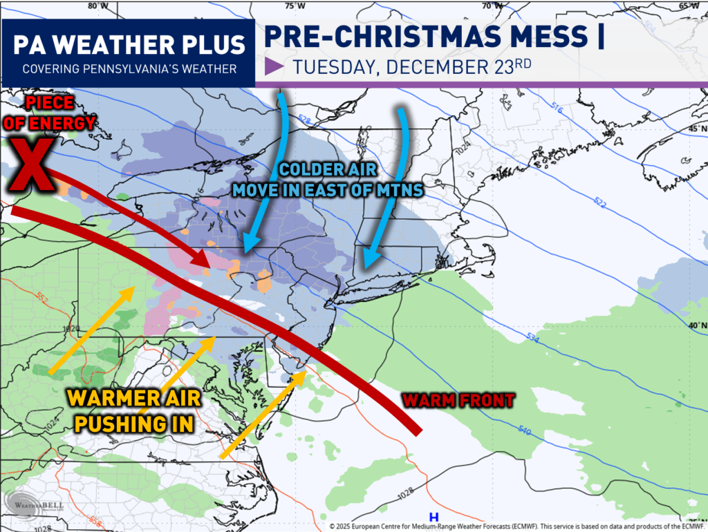
What is going on with this system? A piece of energy will be moving into Pennsylvania late Monday night and into Tuesday morning as a warm front lifts northward. Colder air will be filtering in on the east side of the Appalachian Mountains, known as ‘Cold Air Damming’. Since cold air is much denser than warm air, it piles up, and the mountains act as a wall. With this setup, central and eastern Pennsylvania is favored for an increase in wintry mix while western Pennsylvania warms up with flow, as the cold air gets “blocked” east of the ridges.
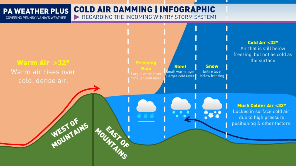
Here is one of my older graphics showcasing the idea of “Cold Air Damming” with how the variety of precipitation types that occur east of the mountains. This will occur on Tuesday as areas change from snow to sleet and eventually to freezing rain.
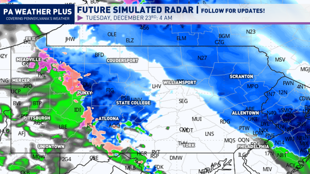
FUTURE SIMULATED RADAR:
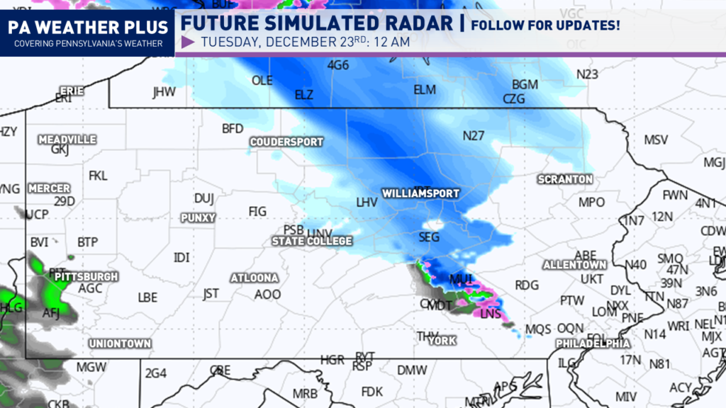
The midnight hour has trended drier, with a band of snow expected to develop across portions of central Pennsylvania. The rest of the state will be drier until later into the night.
Heading closer to the morning commute, much of Pennsylvania will either see a wintry mix or steady snow. The worst impacts will be through central and eastern Pennsylvania around 4 AM.
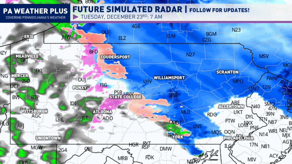
By the morning commute, a wintry mix or freezing rain will be falling across central Pennsylvania. This will cause a messy morning commute in those areas that see falling wintry mix or snow. Most of eastern Pennsylvania will be either dry or under a snowfall band by this time.
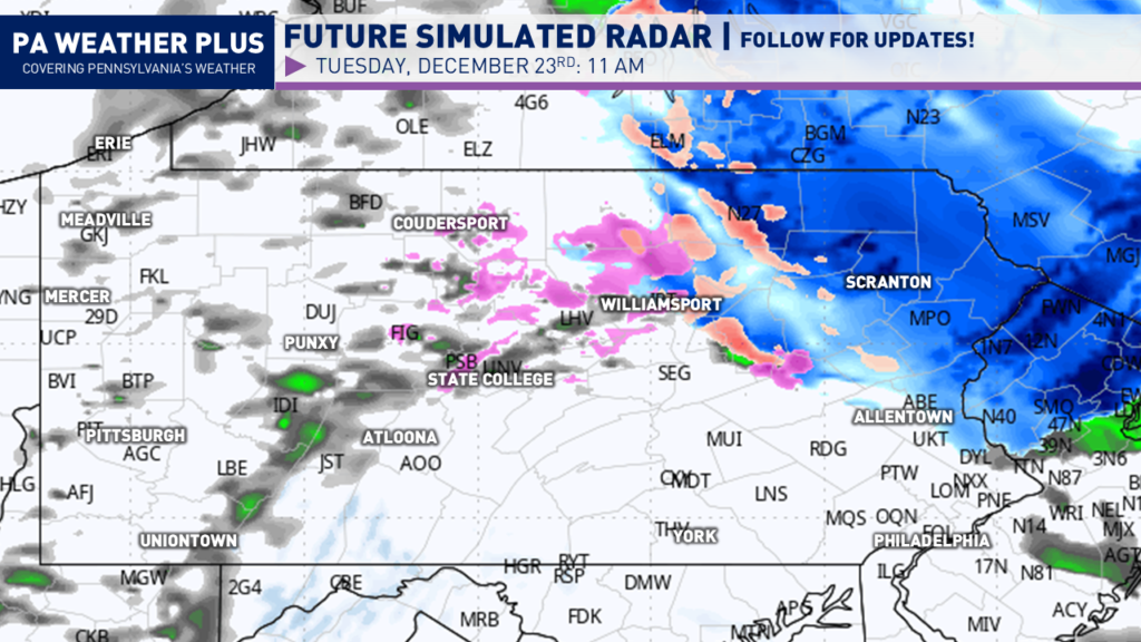
Heading closer to lunch hour, much of the snow will begin to changeover to freezing rain or mix, lingering across north-central Pennsylvania with snow continuing across northeastern Pennsylvania. The remainder of the state will either begin to dry out or changeover to plain rain.
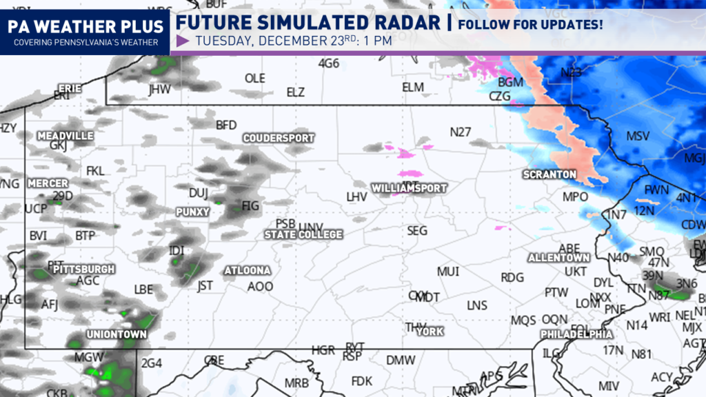
By the mid-to-late afternoon on Tuesday, everyone should begin to dry out. Lingering freezing drizzle will be possible across northeastern Pennsylvania. I have a page on the website dedicated to giving you a more accurate timing forecast for your given location. Check it out here! Your Local Weather
WINTER WEATHER ROAD CONDITIONS & TIMING:
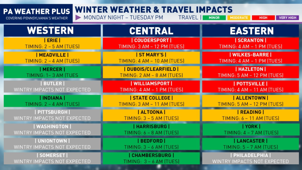
HIGH: Snow and/or ice will affect most roadways and many highways and interstates. Hazardous driving conditions are expected, with an increased risk for accidents. Non-essential travel is discouraged.
MODERATE: Snow and/or ice may impact scattered roadways and some highways. While conditions are less severe, accidents are still possible—especially during steadier wintry precipitation. Use caution, slow down, and allow extra travel time.
MINOR: Isolated snow- and/or ice-covered roads are possible. While impacts are limited, slick spots can still develop. Remain alert, reduce speeds, and drive with caution.
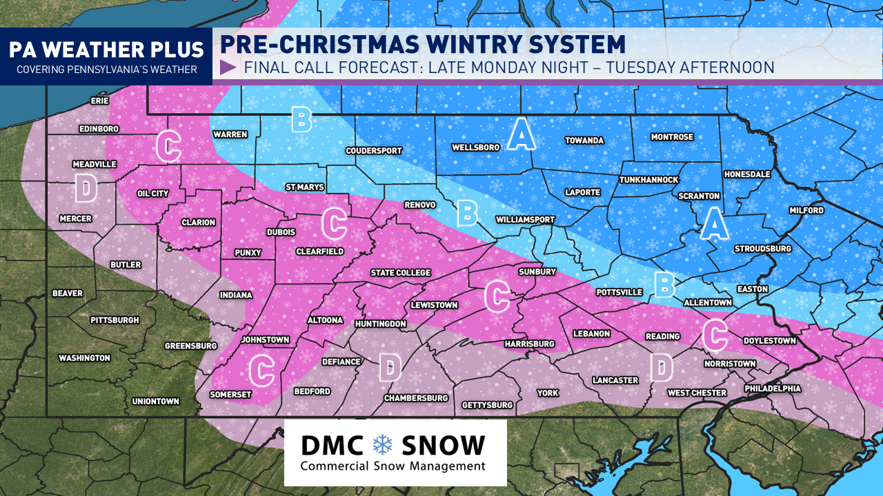
FINAL CALL SNOW / ICE IMPACTS:
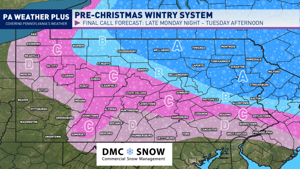
AREA A: Periods of light to moderate snow expected Monday night through Tuesday morning. Snow will changeover to sleet/freezing rain late Tuesday morning and into the afternoon hours. Expect hazardous travel Tuesday morning with snow/ice-covered roadways. 2 to 4 inches of snow expected with less than 0.05″ of ice.
AREA B: Periods of light to moderate snow mixed with sleet expected Monday night Tuesday morning. Snow will changeover to sleet/freezing rain mid Tuesday morning, changing to plain rain by the early Afternoon. Expect hazardous travel on Tuesday morning with snow/ice-covered roadways. 1 to 2 inches of snow expected with less than 0.05″ of ice.
AREA C: Periods of snow/sleet expected early Tuesday morning before changing over to freezing drizzle/rain. Freezing rain lingers into the first few hours of the morning commute before changing to mostly plain rain by mid-morning. Higher elevations and hills will hold icing the longest. Expect hazardous travel on Tuesday morning with areas of icy roadways. Coating to 1 inch of snow/sleet expected with less than 0.05″ of ice.
AREA D: Onset of precipitation may begin as snow/sleet before briefly changing to freezing rain and then plain rain. Winter weather impacts should only last 1 – 2 hours. Snowfall accumulations of less than a half inch are expected, with only a brief glaze of ice possible.
This remains a highly complicated storm system with a variety of precipitation types expected. I will continue to update you with the latest information on social media.
-Meteorologist Denys K.