

December refuses to let up across Pennsylvania. After multiple rounds of cold air and accumulating snow earlier this month, attention now turns to the next—and potentially most impactful—winter storm so far. This system is expected to bring significant travel impacts, with either an ice storm or a heavy snowstorm likely, depending on your location. Read below for all of the important details!
7:20 PM UPDATE: Read the FINAL CALL forecast Here: LINK TO FINAL CALL FORECAST
Estimated reading time: 5 minutes
JUMP TO THE FOLLOWING
METEOROLOGY SET-UP:
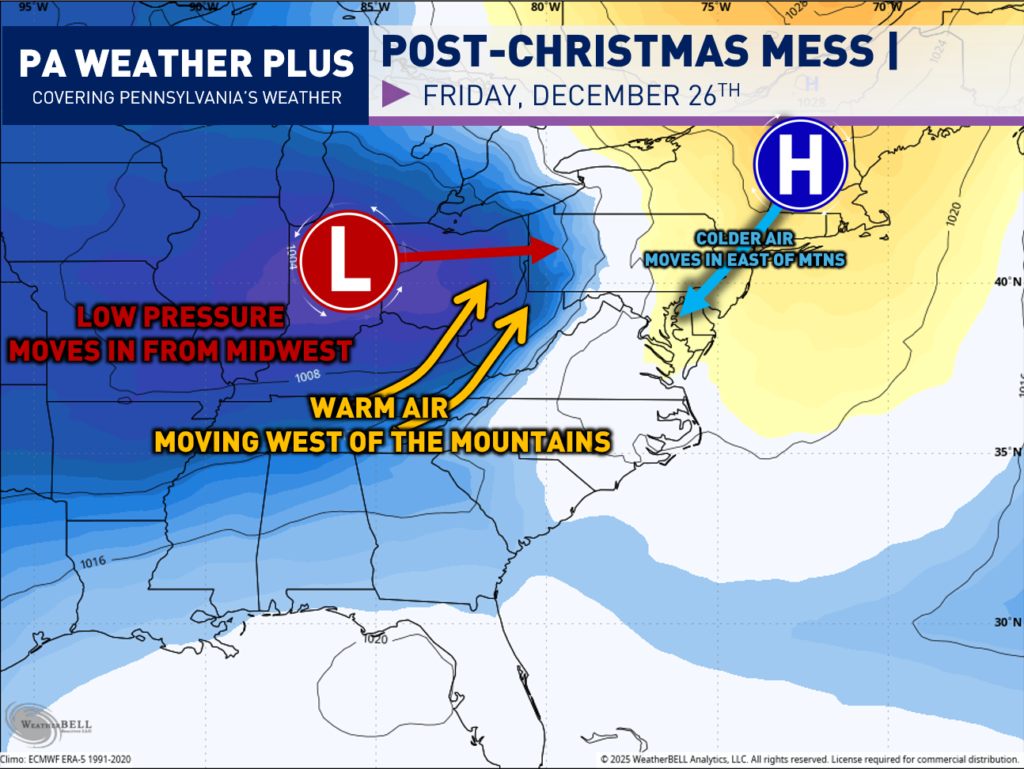
I always like to include some meteorology on the blogs to learn more about the setup! In this scenario, it will be a classic “Cold Air Damming” storm. A strong high-pressure system will lock in across New England, trapping cold air east of the Appalachian Mountains. A robust low-pressure system will be moving in from the Midwest, bringing with it warmer, southerly air.
As the warmer, moist air collides with Arctic air from the north, we are in the crosshairs here in Pennsylvania for a significant winter storm.
The collision of these two stark air masses will also increase the snowfall and ice rates. Those who see an all-snow event will likely see very heavy snowfall rates for periods of time.
WHEN WILL WINTRY PRECIPITATION BEGIN?
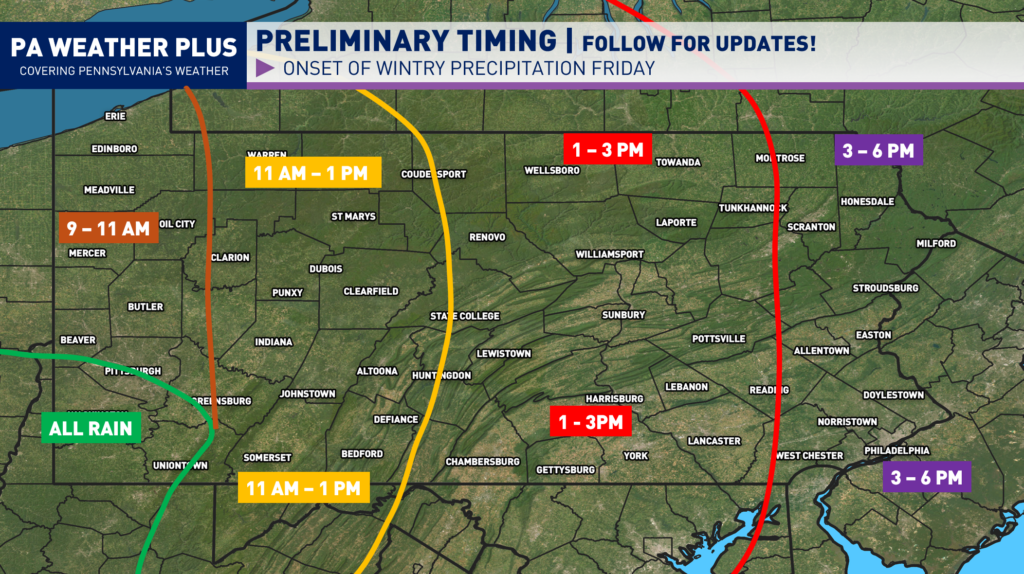
The winter storm is on track to arrive sometime Friday, late morning and into the afternoon hours. There has already been a trend toward a faster arrival of wintry weather. The farther west you are located, the sooner the winter precipitation will begin. As I noted, these storm systems tend to move in quicker than expected. I would not be surprised to see these times shift sooner, depending on the exact speed of the storm. I will continue to update as needed.
WINTER WEATHER ROAD CONDITIONS & TIMING:
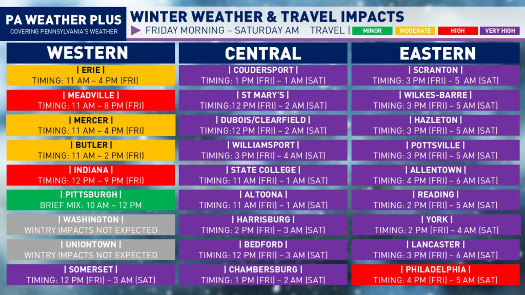
VERY HIGH: Widespread snow and/or ice will cover nearly all roadways, including major highways and interstates. Severe winter storm conditions will create extremely dangerous travel. Vehicles may become stranded, especially during the heaviest snow and/or ice. Travel will be impossible at times. Do not travel unless absolutely necessary.
HIGH: Snow and/or ice will impact most roadways, including many highways and interstates. Hazardous driving conditions will increase the risk of accidents. Avoid non-essential travel.
MODERATE: Snow and/or ice will affect scattered roadways and some highways. While conditions remain less severe, accidents can still occur. Use caution, reduce speeds, and allow extra travel time.
MINOR: Isolated roadways may become snow- or ice-covered. Impacts remain limited, but slick spots can develop. Stay alert, slow down, and drive with caution.
I have a page on the website dedicated to giving you a more accurate timing forecast for your given location. Check it out here! Your Local Weather
SECOND CALL SNOW / ICE FORECAST:
Keep in mind, the mixture of sleet & freezing rain across much of the state will make for dangerous road conditions throughout the storm. The heaviest and steadiest snow will hold to northeastern Pennsylvania.
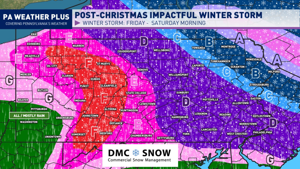
SNOW / SLEET ZONES:
AREA A: Likely all snow. Heavy to very heavy snowfall rates expected during the peak of the storm, upwards of 2″+/hr. Total snowfall accumulations of 7 to 11 inches are expected. Expect nearly impossible travel conditions throughout the storm.
AREA B: Likely mostly snow, mixing with sleet at times. Heavy snowfall rates are expected during the peak of the storm, exceeding 1″/hr at times. Total snow and sleet accumulations of 4 to 7 inches are expected. Expect nearly impossible travel conditions throughout the storm.
AREA C: Mixing between heavy snow and heavy sleet. A brief period of freezing rain is not ruled out. While snowing, snowfall rates may exceed 1″/hr at times. Total snow and sleet accumulations of 2 to 4 inches are expected. Expect nearly impossible travel conditions throughout the storm.
SLEET / FREEZING RAIN ZONES:
AREA D: Mixing between bursts of snow and heavy sleet. Sleet may changeover to freezing rain for periods of time. Total snow and sleet accumulations of 1 to 2 inches. Up to a tenth of an inch of freezing rain is possible. Expect nearly impossible travel conditions throughout the storm.
AREA E: Bursts of some snow and mostly sleet at onset, changing over to freezing rain. Freezing rain will continue throughout the remainder of the storm’s duration. Total freezing rain accretion of 0.10 – 0.25″ expected. Total snow and sleet accumulations of up to 1 inch. Expect nearly impossible travel conditions throughout the storm.
AREA F: Greatest potential for a significant ice storm. While precipitation may briefly begin as snow and sleet, expect prolonged periods of steady freezing rain throughout the remainder of the storm. Total freezing rain accretion of 0.25 – 0.50″ expected. Heavier freezing rain accretion will lead to power outages and downed trees. Expect impossible travel conditions.
FRINGE ZONES:
AREA G: Precipitation will begin as periods of sleet and freezing rain before changing to rain. A trace to localized areas of 0.10″ of freezing rain accretion is expected.
ALL RAIN AREA: Sorry, Pittsburgh region. Too warm again. Although, consider yinz as luck because an ice storm is not fun to deal with!
Thank you for tuning in and reading through all of the forecast details. I will continue to post updates on Facebook, Instagram, and X. A final call forecast will be released late Thursday evening or early Friday morning.
-Meteorologist Denys K
