Estimated reading time: 6 minutes
We have a good soaking of rain with a low-pressure system coming our way over the next 24 hours! Unfortunately, it may put a damper on pre-Halloween plans. Rain and gusty winds will be expected throughout the majority of Thursday. Some of these impacts could linger into the day on Friday.
JUMP TO THE FOLLOWING:
ATMOSPHERIC SETUP:

We have a dynamic low-pressure system that will be strengthening across the Ohio Valley and Eastern United States. This will provide us our steady rain and gusty winds, and it moves through Pennsylvania. Melissa will have some impacts. It will provide a river of moisture from the tropics. This could enhance our rainfall amounts. Overall, this is quite the dynamic setup with a mature storm system!
FUTURE SIMULATED RADAR:
Disclaimer: Keep in mind, these are simulated radar projections. They use high-res modeling. They may not be exactly 1:1 to what occurs from Sunday through Monday night. NOTE: For a more definitive timing for your location, check out the Your Local Weather page!
While Wednesday will be dry, rain will quickly overspread the region during the overnight hours. By 2 AM on Thursday, much of Pennsylvania will begin to see rain with some of it steady at times. This is as our low-pressure system begins to develop and move northward.

By the morning commute, rain showers will continue across much of Pennsylvania with the steadiest rain toward northern Pennsylvania.

Steadier rain will begin to develop once again across portions of central and eastern Pennsylvania. Some of the rain bands could be on the heavier side.

Rain, steady times, will continue into the afternoon hours across much of Pennsylvania.

By the late afternoon hours, portions of southern Pennsylvania may begin to dry out. This is because of a dry slot that will develop within the low-pressure system. Other areas will continue to see rain, heavier at times.

By the evening hours, rain showers will primarily continue across eastern Pennsylvania. As the low pressure system begins to pull away later Thursday and into early Friday morning, the rain showers will end west-to-east.

By Friday, there will be lingering moisture across portions of northern and western Pennsylvania. This will allow for areas of showers, but likely these will be short-lived and light.

NOTE: For a more definitive timing for your location, check out the Your Local Weather page!
WIND GUST FORECAST:
The rain will not be the only main concern with the low pressure system. Gusty winds will occur as it passes through. Some of the highest wind gusts may not happen until Friday afternoon and evening. This is because colder and drier air filters on the backside of the low-pressure system. This air will help to increase the wind gusts.

AREA A – Thursday Afternoon Wind Gusts 30 to 35 MPH. Friday Afternoon Wind Gusts Upwards to 40 to 50 MPH. A few power outages may result with a tree down or two.
AREA B – Thursday Afternoon Wind Gusts 25 to 35 MPH. Friday Afternoon Wind Gusts 30 to 45 MPH. Power outages and any tree damage should be sporadic, although those more prone to power outages may be at some risk, primarily on Friday.
AREA C – Thursday Afternoon Wind Gusts 15 to 25 MPH. Friday Afternoon Wind Gusts 25 to 35 MPH. Power outages and tree damage is not expected.
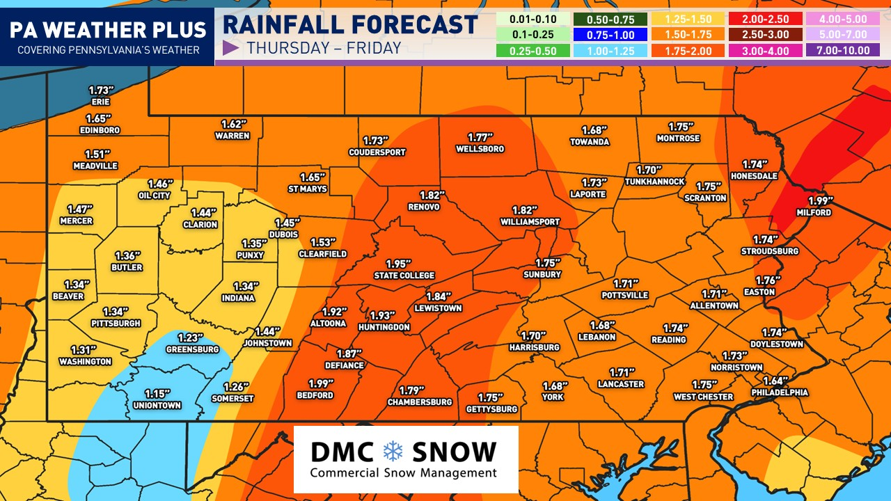
RAINFALL FORECAST:

A general 1 to 2 inches of rain is expected. The best chance for this is across central and eastern Pennsylvania. Hurricane Melissa will not have direct impacts. However, there is a moisture connection with the hurricane. This will increase the atmospheric moisture across the region. It will aid in more beneficial rainfall. Flooding is not expected, although any heavier rain showers may pose a minor risk for ponding and perhaps minor flooding in flood-prone and low-lying areas.
REMEMBER: For a more in-depth forecast based on your location, please visit https://paweatherplus.com/your-local-weather/. This page was created with NWS/NOAA data and will give you a more in-depth forecast!
Key Takeaways
- A low-pressure system will bring rain and gusty winds to Pennsylvania over the next 24 hours, affecting Halloween plans.
- A dynamic setup will increase rainfall, especially in central and eastern Pennsylvania, with predictions of 1 to 2 inches of rain.
- Wind gusts will reach 30 to 50 MPH on Friday, leading to potential power outages and tree damage in some areas.
- Lingering moisture may cause light, short-lived showers on Friday, primarily in northern and western Pennsylvania.
- Check localized forecasts for timing and more specific impacts at Your Local Weather.
FOR MORE UPDATES, FOLLOW US ON FACEBOOK!
Share below to spread this weather update to your family, friends, etc, to keep them weather aware!
-Meteorologist Denys Khrulov