

Estimated reading time: 5 minutes
It has been quite the busy winter, and it sure isn’t coming to an end anytime soon. With Saturday’s snowfall event now coming to an end, I am now looking into the future- which is only to tonight! Today’s storm set a boundary along the East Coast, which will be a favorable zone of development for a coastal system to develop. This coastal system, albeit weaker, will spread areas of light snow into much of eastern Pennsylvania. The timing of phasing with different pieces of energy are holding back from this becoming a much larger snowstorm, which you either should be relieved (snow-haters) or maybe a little sad (snow-lovers). The snowfall map is located at the bottom of the blog post, or you can skip to it by clicking the link right below!
CLICK TO JUMP TO THE FOLLOWING:
METEOROLOGY SET-UP:
This is a nerdy explanation of why tomorrow’s system will be broken up into “two waves”!
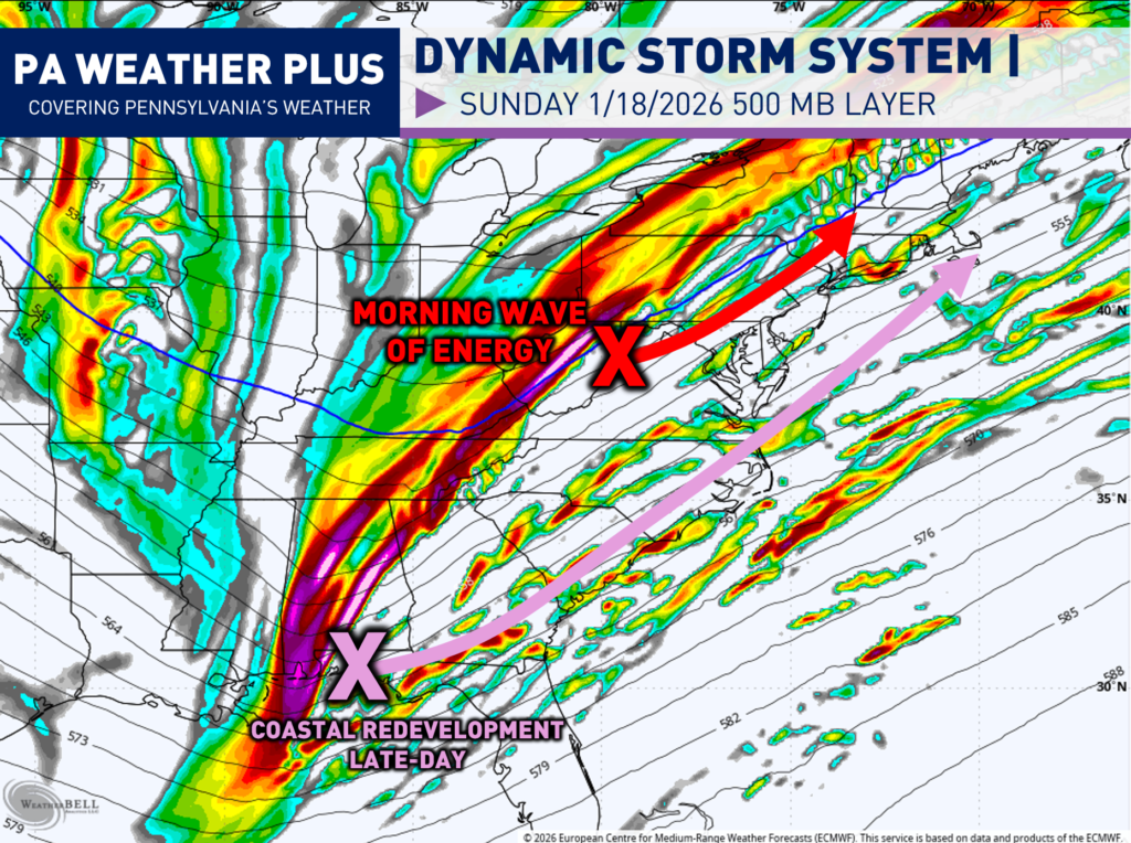
The 500mb layer of the atmosphere (18,000 feet above the ground) is one of the most important in regard to steering weather patterns. The 500mb level is high enough to be above local surface features (terrain, friction, local temperature variations) but low enough to stay connected to weather systems. Then, vorticity is just a fancy meteorology term that means spin in the atmosphere. More vorticity equals more spin, which equals more disturbed weather and vice versa.
The first wave of vorticity will be with a shortwave that will be moving into the northern Mid-Atlantic. This will help to bring areas of snow to Pennsylvania during the morning hours. The second wave of precipitation will come with the coastal development, which will be a much stronger shortwave of energy at 500 MB. Depending on how amplified the second piece of energy is, will depend on how strong the coastal storm will be. A westerly/stronger piece will allow for additional snow and vice versa.
SIMULATED PENNSYLVANIA FUTURE RADAR:
Here is GIF of the future radar throughout late tonight, into tomorrow, and then tomorrow evening. The GIF will play through slowly, highlighting all of the features of the incoming coastal storm.
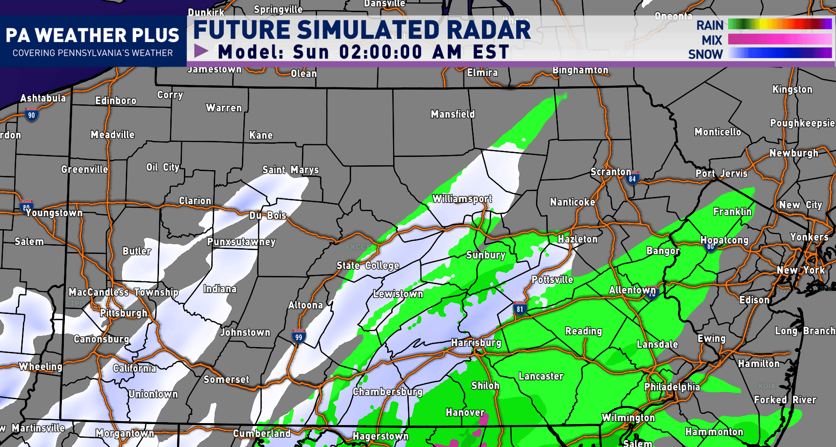
FIRST ROUND OF SNOW: Begins late tonight into tomorrow morning. There will be some steady bands, especially through sunrise across portions of eastern Pennsylvania. This is when roadways will be the worst for the event, and I would not be surprised for some surprise banding to drop snowfall rates upwards of 1″ an hour, similar to how it was Saturday morning.
LULL IN THE ACTION: Midday will feature some drier air, and temperatures may warm up near or above freezing in spots, which may allow for melting on roadways. This will probably be the best time to travel.
SECOND ROUND OF SNOW: As our coastal storm races up the East Coast, a second round of snow will be expected during the late-afternoon and evening hours. Temperatures will begin to fall as well, so if you are out on the roadways, you will need to watch for new developing slick spots and covered roadways.
PENNSYLVANIA ROADWAY IMPACTS:
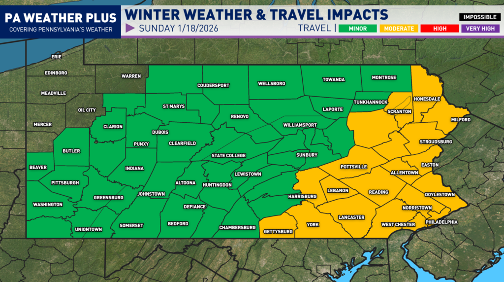
Here is a preliminary update on the winter weather travel impacts expected across the state at anytime on Sunday, January 18th. This is a new graphic style I am trying for travel impacts, so I will try to better confine county boundaries with elevation over the next few updates.
MODERATE: Snow and/or ice will affect scattered roadways and some highways. During heavier snowfall rates, all roadways may become covered for short periods of time. While conditions remain less severe, accidents can still occur. Use caution, reduce speeds, and allow extra travel time.
MINOR: Isolated roadways may become snow-covered. Impacts remain limited, but slick spots can develop. Stay alert, slow down, and drive with caution.
FINAL CALL SNOWFALL AMOUNTS:
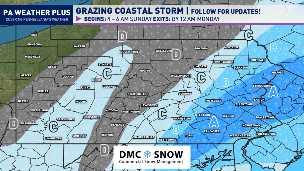
AREA A: Storm total of 2 to 4 inches of snow expected. If morning banding is more intense than projected, I would not be surprised for localized spots to pick up 4 or even 5 inches. This includes towns/cities such as: Mildford, Stroudsburg, Easton, Allentown, Reading, York, and Lancaster.
AREA B: Storm total of 1 to 2 inches of snow expected. This includes towns/cities such as: Scranton, Harrisburg, and Gettysburg.
AREA C: Storm total of a Coating to 1 inch of snow expected. This includes towns/cities such as: Montrose, LaPorte, Chambersburg, St. Mary’s, Indiana, Greensburg, and Uniontown.
AREA D: Areas of flakes and flurries expected. A few areas may pick up a dusting of snow with overall minimal impacts. This includes towns/cities such as: Wellsboro, State College, Clarion, Pittsburgh, and Beaver.
THANK YOU FOR READING!
For a continuation of updates, make sure to follow PA Weather Plus on Facebook. Thank you for all of your continued support! Take it easy tomorrow and make smart driving decisions if you have to be out on the roadways. Feel free to reach out with any questions and/or concerns.
-Meteorologist Denys K.
