We are beginning to transition to spring after a long winter (but don’t discount any threats for snow/cold until early April). Spring brings severe weather to Pennsylvania. This is my first severe weather zone map of the season, and this is looking to be an interesting set-up with near record warm temperatures expected Saturday afternoon, allowing for this severe weather risk.
CLICK TO JUMP TO THE FOLLOWING:
LATE SPRING WARMTH:
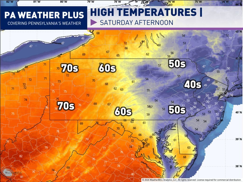
The main reason for the early March severe weather risk tomorrow is due to the abnormal warmth expected across western Pennsylvania. Western Pennsylvania will see high temperatures 25 – 30 degrees ABOVE average, which could even threaten some record highs. Central and eastern Pennsylvania will be cooler due to a “back door cold front”.
Combined with the 60s and 70s across western Pennsylvania, dew point values will be in the upper-50s to mid-60s. It may feel a bit “muggy” tomorrow, and this will help grow the storm fuel needed for strong to severe thunderstorms. An incoming cold front will provide the wind shear, which is also needed for severe weather. All in all, we have a lot of ingredients coming together for this severe weather risk!
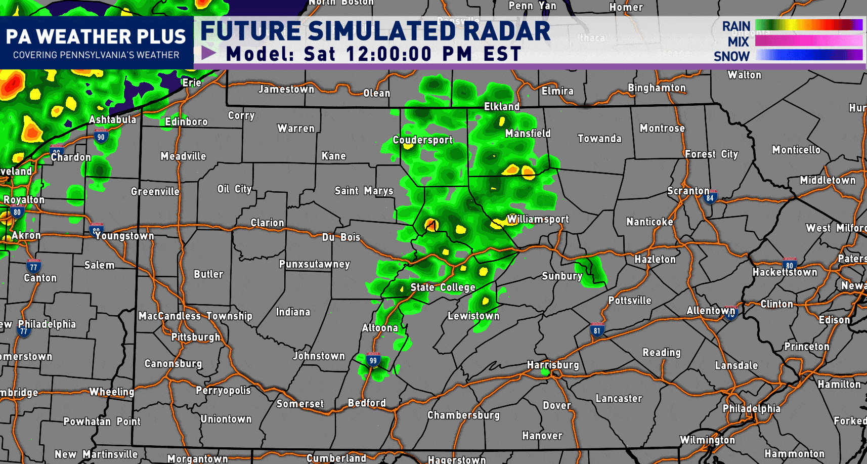
SIMULATED FUTURE RADAR:
Keep in mind, this is a radar simulation and may vary from what actually occurs. This is just a way to see the bigger picture of what may occur. A detailed “best timing” for towns/cities across the state is listed below!
Early Afternoon: Showers and some thunderstorms will begin to fire across far western Pennsylvania.
Mid-to-Late Afternoon: This will be the ‘peak’ timing for the strongest storms due to the overlap of the warmest temperatures and humidity. These will be moving through western Pennsylvania at this time.
Late Afternoon to Early Evening: As the storms move into central Pennsylvania, they will encounter much more stable air and begin to weaken. These could make it as far east as Williamsport before quickly falling apart and becoming just localized downpours/rumbles of thunder in eastern Pennsylvania.
SEVERE WEATHER OUTLOOK:
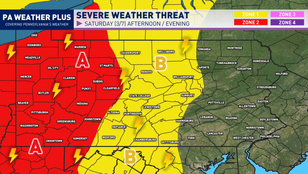
ZONE 2 (A)- Watching for *SCATTERED* strong to severe thunderstorms. These storms may produce damaging wind gusts and some hail. The tornado threat remains isolated, and if one were to occur, it would likely be low intensity (EF0-EF1). Non-severe thunderstorms may still produce gusty winds, lightning, and heavy rainfall. This includes towns/cities such as: Erie, Meadville, Mercer, Butler, Pittsburgh, Washington, Uniontown, and Indiana.
ZONE 1 (B)- Watching for *ISOLATED* strong to severe thunderstorms. These storms may produce strong wind gusts. Non-severe thunderstorms may still produce gusty winds, lightning, and heavy rainfall. This includes towns/cities such as: Wellsboro, Williamsport, State College, Bedford, and Gettysburg.
Keep in mind, severe weather does not impact every house or neighborhood. Unless it is a large outbreak, severe weather impacts will differ even across small areas. It is always good to be prepared by having multiple ways of receiving severe weather alerts and a shelter to take cover in when severe weather strikes.
IN-DEPTH TIMING OUTLOOK:

While this graphic was popular in the winter for winter precipitation start/end times, I thought of bringing this back with a ‘best timing’ scale for the potential for these strong to severe thunderstorms. Keep in mind, ‘best timing’ does not guarantee you will see thunderstorms in that timing, and in some instances may occur outside of this timing box if the environmental conditions change. For a more local percentage and best timing, visit: https://paweatherplus.com/your-local-weather/
Tomorrow will be a good day to remain weather aware and stay tuned for updates. Be prepared for rapidly changing weather conditions. Make sure you have multiple ways to receive severe weather alerts. Remember, when you hear thunder, head indoors! Stay safe and stay tuned! – Denys