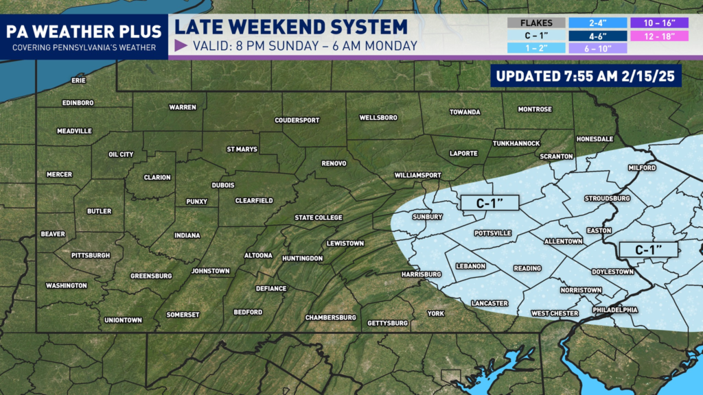
IMPORTANT CHANGE SUNDAY MORNING (2/15/2026):
As I mentioned in the blog post in the meteorology section, this system remains very susceptible to small changes between the northern and southern streams of energy. More interaction would’ve led to a larger storm, while less interaction leads to a non-storm event, and the changes are non-linear. Friday and Saturday, we’ve seen trends toward more interaction, which led me to release a bullish “first call” forecast yesterday morning and fit the observations at that time. Overnight, we’ve seen the northern stream of energy trend more northward over Minnesota/Wisconsin, which has large implications upstream and won’t allow for a snowier solution. This change of literally miles of differences allows for a highly volatile setup, which I’ve been saying for days.
In our case, rain showers will changeover to wet snow showers later tonight across eastern Pennsylvania. I expect a coating of an inch of snowfall on mostly elevated and colder surfaces. Most roadways should fare out okay unless there is a steadier band that could briefly cover roads/interstates. It is occurring at night and with falling temperatures, take it slow tomorrow morning, especially if your area received steadier banding.
OLD BLOG POST FROM 2/14/2026:
All in all, model guidance throughout the week leading up to this weekend’s potential has been abysmal, with the majority of the model guidance holding south and weak for the event. The ECMWF/ECMWF AI suite has been an “outlier” north- but those are your best-performing models and shouldn’t be completely ignored. Over the last 12 hours, we’ve seen a significant shift toward a more amplified storm system, allowing for an impactful event for the majority of eastern Pennsylvania, and possibly into central Pennsylvania. Read here for all of the details!
If you are here for the snowfall map only, press “FIRST CALL SNOWFALL AMOUNTS” to jump to the bottom of the article!
CLICK TO JUMP TO THE FOLLOWING:
METEOROLOGY SET-UP:
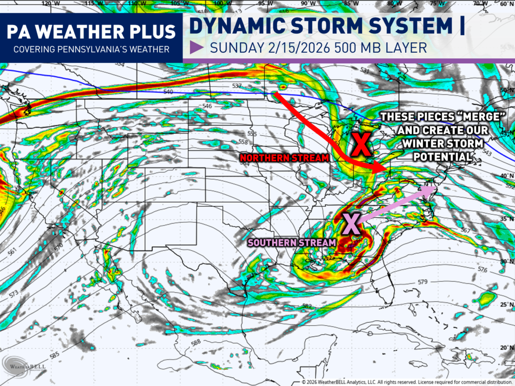
The 500mb layer of the atmosphere (18,000 feet above the ground) is one of the most important in regard to steering weather patterns. The 500mb level is high enough to be above local surface features (terrain, friction, local temperature variations) but low enough to stay connected to weather systems. Then, vorticity is just a fancy meteorology term that means spin in the atmosphere. More vorticity equals more spin, which equals more disturbed weather and vice versa.
In this setup, meteorologists have been watching the interaction between the northern stream of energy (red) and the southern stream of energy (pink). The majority of model guidance throughout the week has been against these two phasing together, leading to no storm. Over the last 12 hours, and as we got new information from hurricane hunter data, these two pieces of energy have closed in closer with one another, allowing for a cleaner phase and overall a potential winter storm.
It is worth noting that even though these have trended closer over the last 12 hours, this remains a highly volatile setup. It is quite possible we could see this trend backwards from an interaction and lead to a non-issue event OR the trend continues to have a larger phase, and we could see an even larger storm. This is a very, very tough storm system, and small changes in the track of those two streams of energy will have a large impact here in Pennsylvania and across the Northeast.
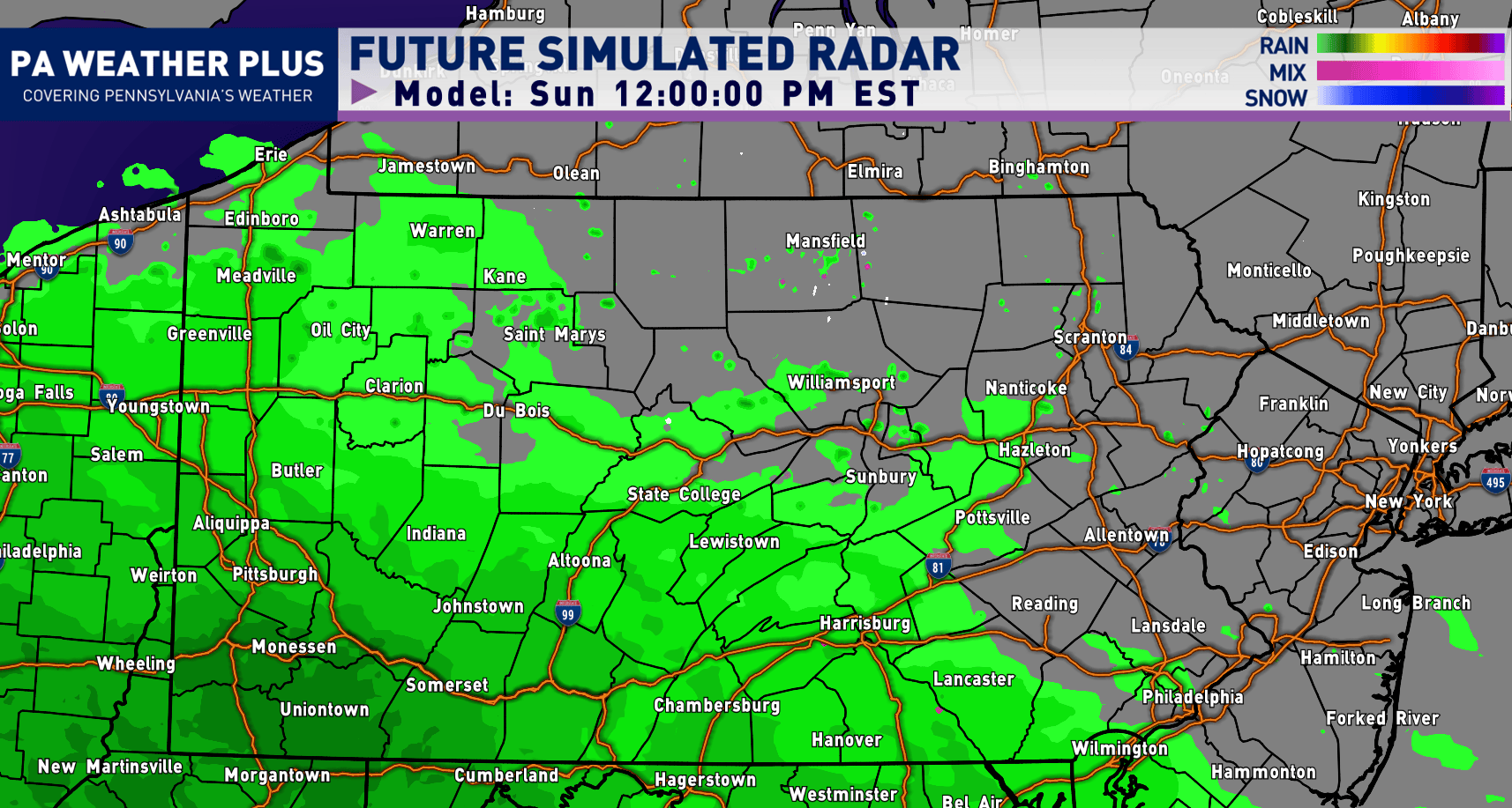
CURRENT FUTURE RADAR SIMULATION:
Early through Mid Afternoon Sunday: It will be too warm for snow to fall so precipitation will begin as rain with many areas in the mid-30s to low-40s as air temperatures.
Mid Afternoon through Early Evening Sunday: Temperatures will begin to cool, and we will begin to see rain changeover to periods of moderate to at times heavy snowfall across central and eastern Pennsylvania.
Early Evening Sunday through early Monday morning: This will be the bulk of the storm as temperatures cool to and below 32 degrees. Expect periods of steady snowfall rates, especially the farther east you are located. Precipitation quickly shuts off before sunrise on Monday. This will be the worst timing for the winter event.
I have a page on the website dedicated to giving you a more accurate timing forecast for your given location. Check it out here! Your Local Weather
NOTE: This still remains a highly volatile setup. A quicker, cleaner phase of the system will allow for a longer duration snow event, while a messier phase would allow for less snowfall.
WINTER WEATHER ROAD CONDITIONS:
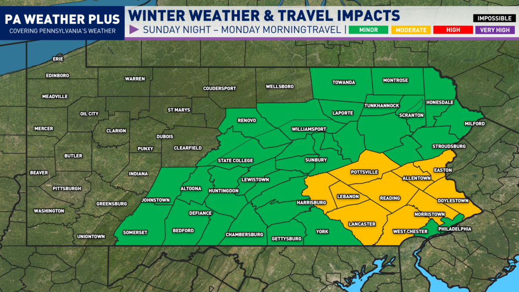
MODERATE: Snow and/or ice will affect scattered roadways and some highways. While conditions remain less severe, accidents can still occur. Use caution, reduce speeds, and allow extra travel time.
MINOR: Isolated roadways may become snow- or ice-covered. Impacts remain limited, but slick spots can develop. Stay alert, slow down, and drive with caution.
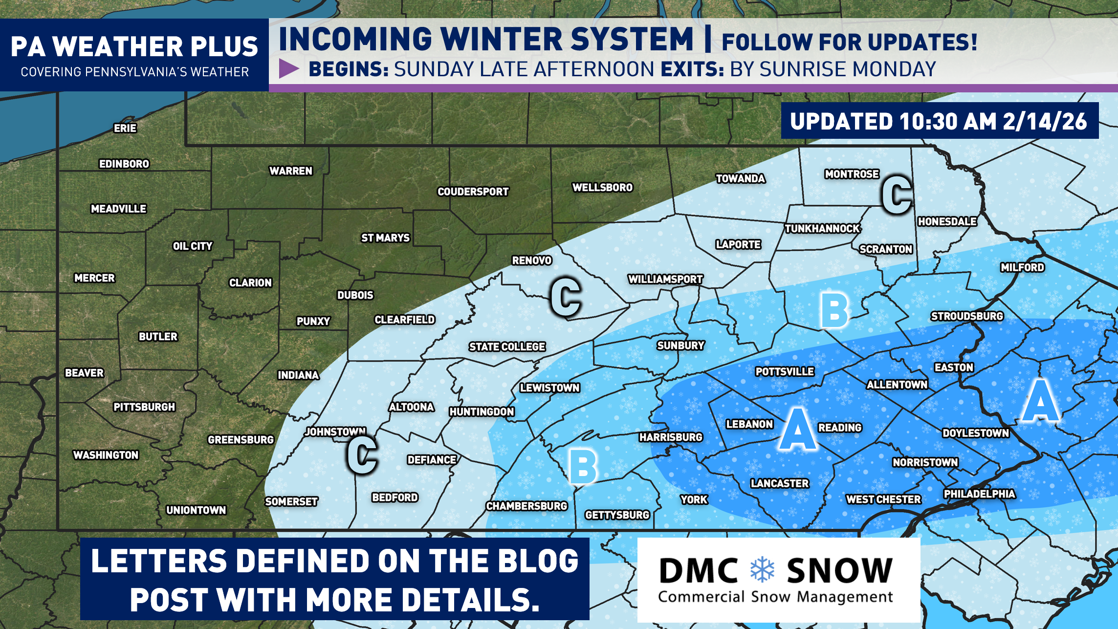
FIRST CALL SNOWFALL FORECAST:
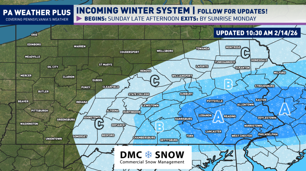
AREA A: An initial start of rain changes over to periods of wet, steady snow Sunday night. 2 to 4 inches of snow expected, although a more amplified system could bring snowfall amounts greater than 4 inches. Expect snow-covered roads into Monday morning with potential business and school delays. Isolated power outages may result due to the wet snow potential, especially if amounts total greater than 4 inches.
AREA B: An initial start of rain changes over to periods of light snow to at times, moderate snow. 1 to 2 inches of snow is expected, although a more amplified storm system could bring snowfall amounts greater than 2 inches. Expect snow-covered roads into Monday morning with potential business and school delays.
AREA C: Rain will changeover to some snow Sunday night. Expect a coating to 1 inch of snowfall, although higher amounts may not be ruled out in a more amplified storm system. Most roadways should remain wet, although in elevations greater than 1500 feet, some snow-covered roadways may be expected.
NOTE: This still remains a highly volatile setup with small changes in the upper-levels of the atmosphere leading to larger changes to the surface. A quicker, cleaner phase of the system will allow for a longer duration snow event, while a messier phase would allow for less snowfall.
A second snowfall blog post will be issued around 8 PM Saturday with a final call by 10 AM on Sunday. Stay tuned for updates! – Denys