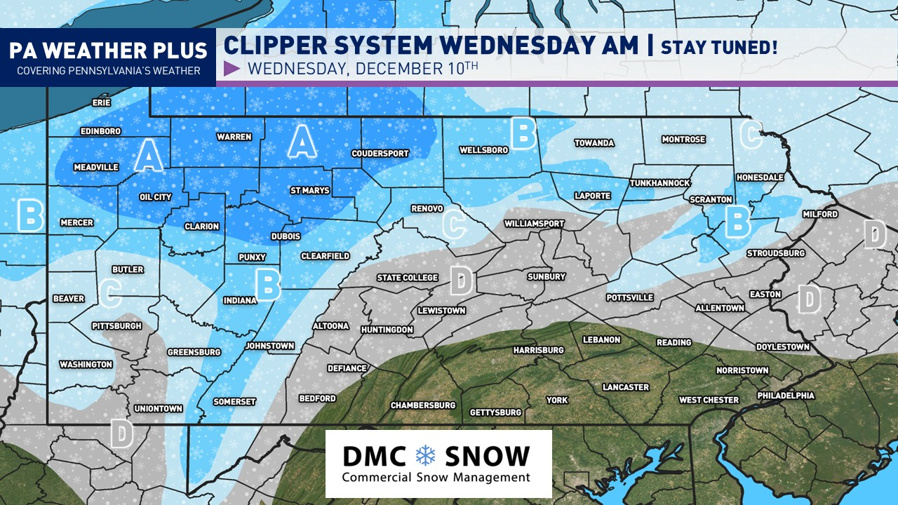
Not only are we jumping on the Polar Express for the Christmas season, but we are also in a “Polar Express” weather pattern as multiple winter systems take aim at Pennsylvania. We’re handling our first system today (Tuesday), while another significant winter storm is lined up to impact the region Friday into early Saturday. This next system could pack a punch, bringing the potential for significant icing and snowfall.
METEOROLOGY SET-UP:
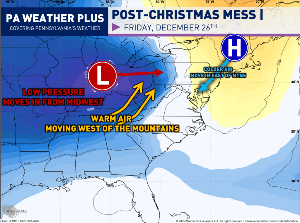
I always like to include some meteorology on the blogs to learn more about the setup! In this scenario, it will be a classic “Cold Air Damming” storm. A high-pressure system will be locked in across New England, which will “dam” up the cold air east of the Appalachian Mountains. A robust low-pressure system will be moving in from the Midwest, bringing with it warmer, southerly air. As the warmer, moist air collides with Arctic air from the north, we are in the crosshairs here in Pennsylvania for a significant winter storm. The collision of these two stark air masses will also increase the snowfall and ice rates. Those who see an all-snow event will likely see very heavy snowfall rates for periods of time.
LATEST MODEL GUIDANCE:
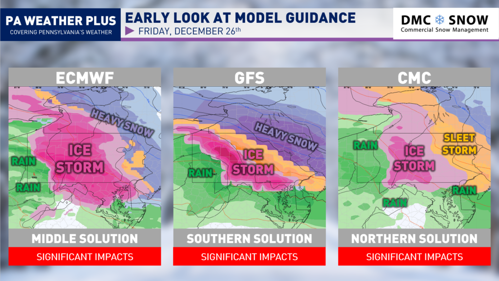
No matter which major global model you look at, they are now agreeing on significant impacts across the region on Friday, December 26th. All show either an ice storm or snowstorm. The exact details vary model-to-model, but is is becoming increasingly likely for prolonged icing across much of central Pennsylvania with the growing risk for heavy snowfall across portions of northeastern and eastern Pennsylvania. This is shaping up to be quite a “nightmare” scenario, given the expected high travel rush post-Christmas.
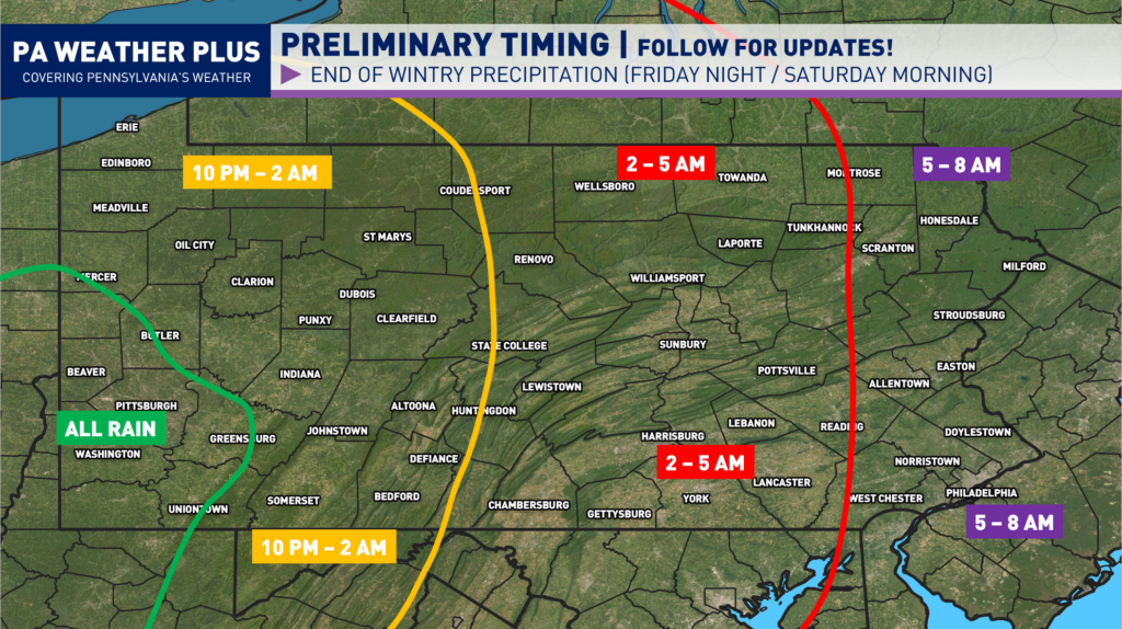
PRELIMINARY TIMING:
The storm is on track to arrive sometime Friday, late morning and into the afternoon hours. Areas farther west should see wintry precipitation arrive sooner. My main concern is that these storm systems could move in faster than expected. This would make a shift in the timing. If you plan to travel on Friday, I strongly recommend changing your plans to travel either before or after the storm, as conditions are expected to be very hazardous.
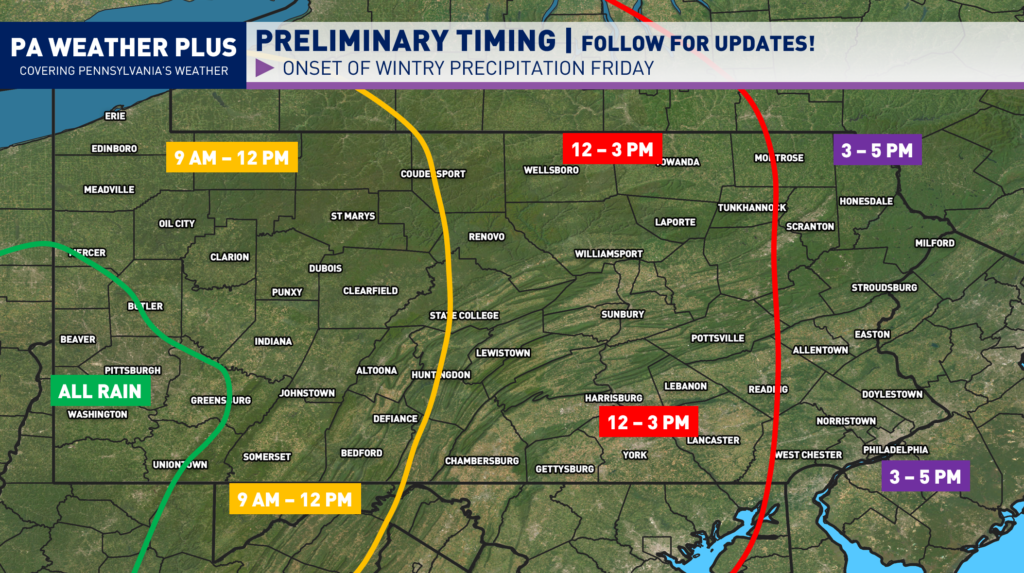
The storm will then exit west-to-east Friday night into early Saturday morning. The rest of Saturday will feature temperatures in the 20s and 30s, so expect back roads to remain hazardous until they are able to be all treated.
NEWEST SCENARIOS:
I currently do not have percentages on either scenario as the probabilities are close to 50/50 for this winter storm, but I am slightly leaning toward the northerly track over the southerly track. I wouldn’t be surprised to see the track shift north and east, turning this into more of an ice storm than a snowstorm for much of the state.
SCENARIO 1 – NORTHERLY TRACK
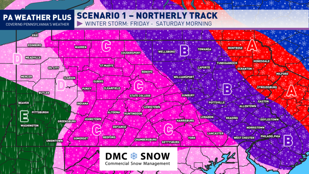
AREA: Significant snowfall amounts of 6″+. With this scenario, heavy to very heavy snowfall would be expected throughout the event. Snow could mix with brief sleet/freezing rain before coming to an end Saturday early morning. It would be a legitimate snowstorm.
AREA B: Moderate snowfall amounts of 3″+ with heavy mixed precipitation. Thump of heavy snow changing over to prolonged periods of sleet and then freezing rain. Up to 1″ of sleet not ruled out with less than 0.10″ of freezing rain accretion.
AREA C: Prolonged period of freezing rain. Initial thump of snow / sleet changing over to freezing rain throughout the duration of the event. Widespread areas would pick up at least 0.20 – 0.25″ of freezing rain with localized amounts up to 0.50″ not ruled out.
AREA D: Brief wintry mix expected before changing over to plain rain. Less than an inch of snow with up to an inch of snow / sleet would be expected.
SCENARIO 2 – SOUTHERLY TRACK
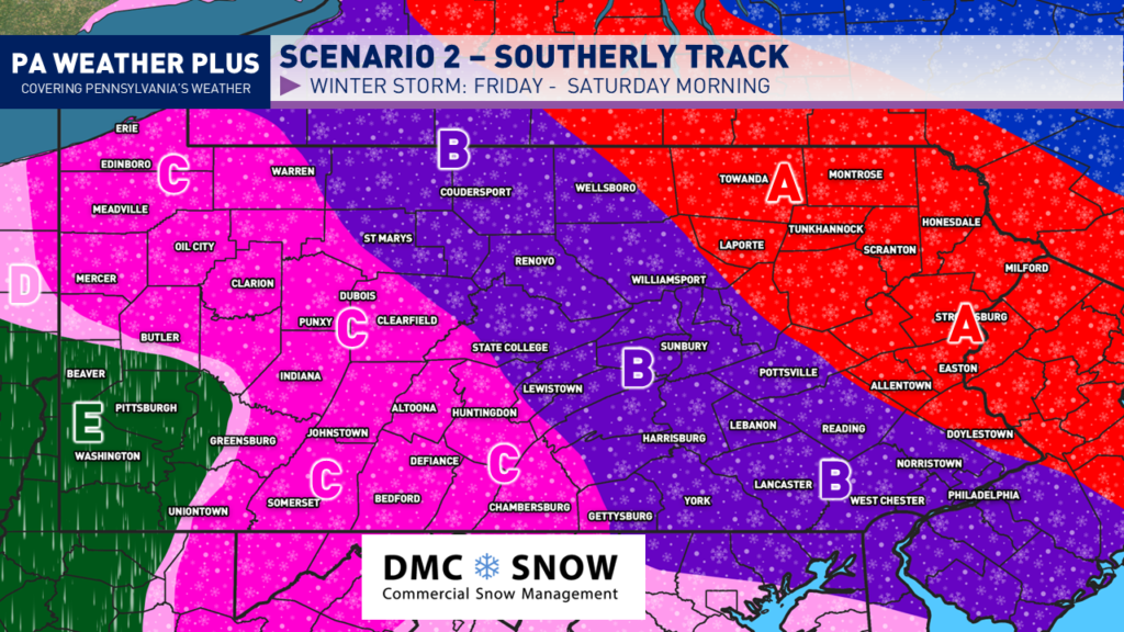
AREA: Significant snowfall amounts of 6″+. With this scenario, storm is expected to produce heavy to very heavy snowfall throughout the event. Snow could mix with brief sleet/freezing rain before coming to an end Saturday early morning. It would be a legitimate snowstorm.
AREA B: Moderate snowfall amounts of 3″+ with heavy mixed precipitation. Thump of heavy snow changing over to prolonged periods of sleet and then freezing rain. Up to 1″ of sleet not ruled out with less than 0.10″ of freezing rain accretion.
AREA C: Prolonged period of freezing rain. Initial thump of snow / sleet changing over to freezing rain throughout the duration of the event. Widespread areas would pick up at least 0.20 – 0.25″ of freezing rain with localized amounts up to 0.50″ not ruled out.
AREA D: Brief wintry mix expected before changing over to plain rain. Less than an inch of snow with up to an inch of snow / sleet would be expected.
No matter the scenario, the state is expected to see significant impacts, either in the form of ice or snow. In order for this event to not go as planned, we would need to see significant weakening on models to go from an amplified system to just a clipper system, which at the moment, the trends do not point in this direction. If you have travel plans Friday through early Saturday morning, it is crucial you stay tuned to updates over the next few days as this forecast evolves. Feel free to follow me on Facebook, X, and/or Instagram!
-Meteorologist Denys K