Good afternoon, folks! I sure hope everyone is taking advantage of the warmer conditions lately across the state. High temperatures have climbed into the 40s, 50s, and even a few 60s. This has expedited the snow melt, but luckily, it hasn’t been melting fast enough to cause flooding concerns. Given it is February, we all know the warmth is a false reality of spring. And in fact that is true- because the pattern is turning colder and more active again.
CLICK TO JUMP TO THE FOLLOWING:
METEOROLOGY SET-UP:
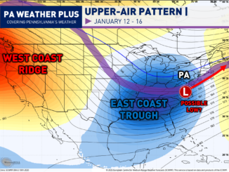
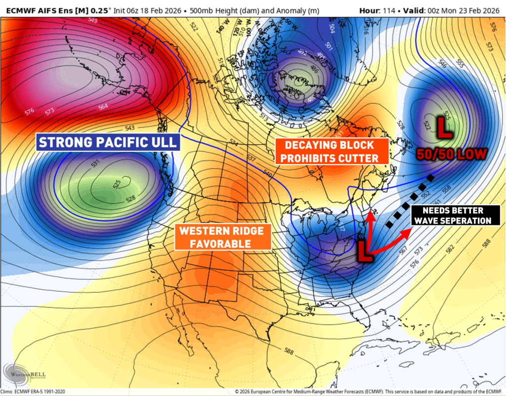
The 500mb level, around 18,000 feet high, strongly steers weather patterns and large-scale storm movement. It sits above terrain effects but stays connected enough to influence developing weather systems.
A strong Pacific upper-level low raises heights over Montana and Idaho and helps build a favorable ridge.
Friday’s storm setup encourages a 50/50 low and a weakening eastern Canada block, limiting a cutter track. Overall, this pattern supports the potential for a significant winter storm.
The main concern is atmospheric “traffic,” or how quickly weather waves move. A 50/50 low forms near 50° latitude and 50° longitude, which explains its name. A strong winter storm needs the eastern U.S. trough to separate from the 50/50 low. That separation allows the system to strengthen and organize.
This requires a slower atmospheric flow so both waves can pull apart. A fast, progressive pattern lowers the chances of that separation happening.
If separation fails, the storm stays weak and quickly exits out to sea. We remain four to five days out, so forecast changes are still likely. The current model spread ranges from a major storm to no impact at all.
If the separation does not occur, we would have a much weaker low-pressure system, and it would connect with the 50/50 low and quickly head out to sea. We are still 4 – 5 days away, so changes are definitely expected, which is why there remains a large spread of potential scenarios, ranging from a large hit to absolutely nothing at all.
WINTER STORM SCENARIOS:
These scenarios are not snowfall maps, but typically these impacts are classified as:
Minor: 1″+, Moderate: 3″+, Significant: 6″+, Major: 12″+
SCENARIO 1- CURRENTLY FAVORED (45%)
This scenario is currently the most favored, which will likely still bring in some snow to much of the state with a glancing blow to the east of Pennsylvania.
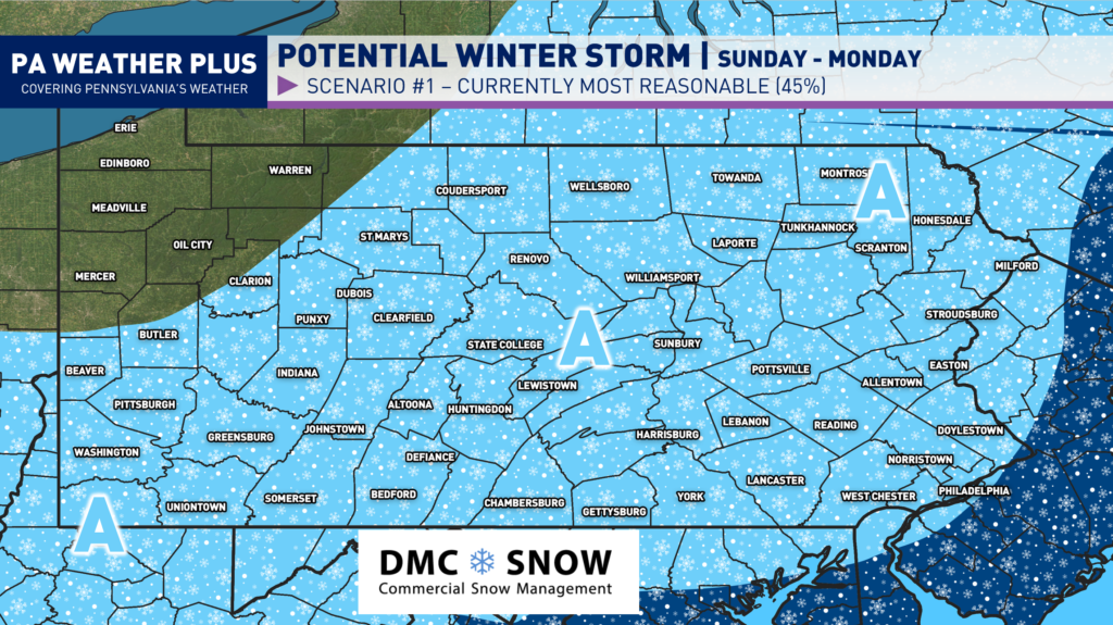
AREA A: With this scenario, we would expect minor snowfall impacts.
SCENARIO 2- SLIGHTLY MORE AMPED, LESS LIKELY (40%)
This scenario is not completely out of the realm, but it is possible if we see a more favorable setup for a growing low-pressure system. This would graze the southern and eastern areas of Pennsylvania with a decent snowfall event, with significant accumulations across far southeastern Pennsylvania.
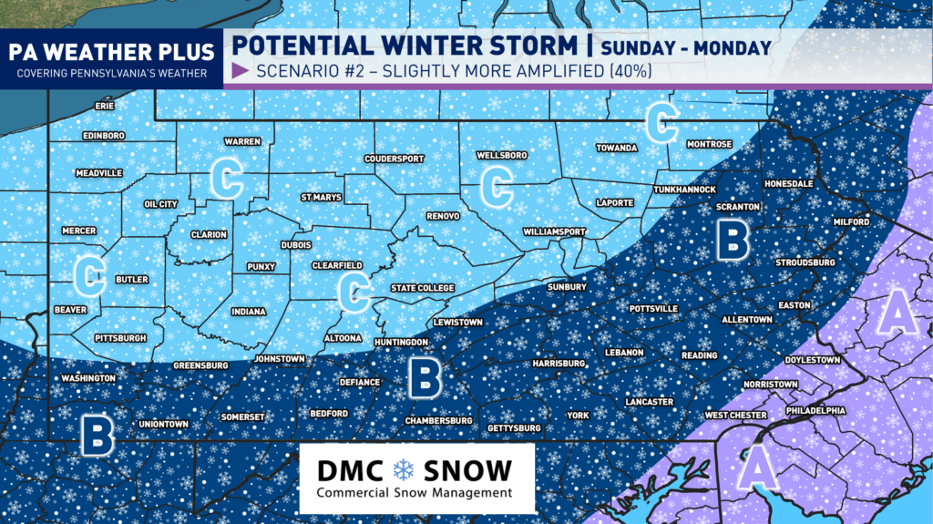
AREA A: In Scenario 2, we would expect significant snowfall impacts.
AREA B: In Scenario 2, we would expect moderate snowfall impacts.
AREA C: In Scenario 2, we would expect minor snowfall impacts.
SCENARIO 3- VERY AMPED, VERY UNLIKELY BUT TOO EARLY TO RULE OUT (15%)
This would be the high-end solution with a perfect setup for a classic East Coast snowstorm, bringing significant to major snowfall impacts into the Commonwealth. While it is still too early to rule out, the odds for this scenario are decreasing with every model run, due to the setup explained in the meteorology section of this blog post (less seperation between 50/50 low and EC Trough).
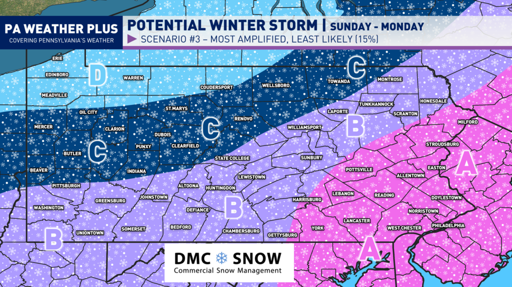
AREA A: With this scenario 3, we would expect major snowfall impacts.
AREA B: With this scenario 3, we would expect significant snowfall impacts.
AREA C: With this scenario 3, we would expect moderate snowfall impacts.
AREA D: With this scenario 3, we would expect minor snowfall impacts.
QUICK CONCLUSION:
All in all, the scenarios range from a “nothing burger” to a large winter storm, which is what you should expect given we are 4-5 days out from this potential storm system. Changes are to be expected, although I would say the odds for high-end events are decreasing. For the most up-to-date updates, make sure to follow on social media and stay tuned to trusted weather sources for this storm. Ignore any snowfall amounts you see posted on any weather page or app until confidence is growing on a particular scenario (typically, less than 3 days, you can begin to take amounts more seriously). Stay tuned for updates!
![]() Hoping for a big snowstorm? This one will have the potential to be a “big” one, which could be similar in impacts to the storm in late January, but odds are beginning to decrease.
Hoping for a big snowstorm? This one will have the potential to be a “big” one, which could be similar in impacts to the storm in late January, but odds are beginning to decrease.
![]() If you are a person who likes the heads-up days in advance, then stay tuned for updates.
If you are a person who likes the heads-up days in advance, then stay tuned for updates.
![]() If you would rather not know until the day before, then kindly scroll and leave your negative comments to yourself. You don’t have to tell me that it will change. It will change.
If you would rather not know until the day before, then kindly scroll and leave your negative comments to yourself. You don’t have to tell me that it will change. It will change.
-Denys