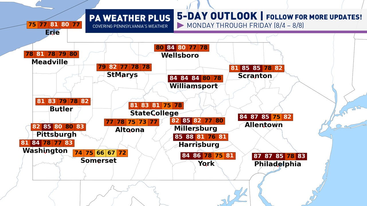
The continuation of our dry and calm weekend will linger into the early part of the workweek as high pressure moves across the region. Monday will be quite warmer compared to Saturday and Sunday, although it will still be not very humid, so it will not feel terribly excessive. A great afternoon for some pool weather! Tuesday will appear to be a near carbon copy of Monday, albeit with slightly more cloud cover. By Wednesday, our first rain chances will begin to arrive, primarily across south-central Pennsylvania and possibly lingering into southeastern Pennsylvania later in the day. These will be on the lighter intensity. This system will then begin to hang around, which means our humidity levels will begin to creep up. On Thursday, there could be a few pop-up showers and perhaps a storm, mainly in western/central Pennsylvania, with variable cloudiness. Friday will be a near carbon copy of Thursday, with intervals of sun and clouds with a chance for pop-up showers across western and central Pennsylvania as our weak disturbance gets stuck in the state.

MONDAY (8/4): High temperatures ranging from the upper-70s to upper-80s. Generally, mostly sunny skies are expected with a few afternoon clouds. Winds out of the east at 4 – 12 mph.
TUESDAY (7/22): High temperatures ranging from the upper-70s to upper-80s. High-level clouds begin to move in south-to-north throughout the day. Winds out of the south-southeast at 6 – 14 mph.
WEDNESDAY (7/23): High temperatures ranging from the upper-60s to mid-80s. Showers may be possible across portions of south-central and south-eastern Pennsylvania, with intervals of sun and clouds for others. Winds out of the southeast at 8 – 16 mph.
THURSDAY (7/24): High temperatures ranging from the upper-60s to low-80s. More clouds than sunshine with isolated showers possible primarily across western and central Pennsylvania. Winds out of the south-southeast at 7 – 15 mph.
FRIDAY (7/25): High temperatures ranging from the low-70s to low-80s. Intervals of sun and clouds. A few showers may be possible primarily across western and central Pennsylvania, although most areas will be mostly dry. Winds out of the southeast at 8 – 16 mph.

Most precipitation chances will be divided up the three days (Wednesday – Friday) in rather lighter periods.
That is all for this week’s forecast. As I get more consistent with doing these blog posts, I hope to add more details and more graphics to help you plan for your week. If you have any questions, please PM on Facebook or email [email protected] and I will be glad to help. For a localized 2-day forecast, go to https://paweatherplus.com/your-local-weather/
-Meteorologist Denys K.