Our dry and calm weekend will carry on into the start of the new workweek; however, showers and thunderstorms will be looming in the forecast as we progress through the week. Monday and Tuesday will appear to be the driest days state-wide, before shower and thunderstorm chances increase as we head into the Wednesday timeframe and beyond. Widespread severe weather and flash flooding does not appear to be a large concern at the moment, but this will continue to be tweaked throughout the week so it will be important to stay tuned to updates. Wednesday and Thursday do look to be the most active days as a cold front will sweep through the state, but depending on the speed of this front, it may or may not stall into the end of the week, which will determine the rain chances on Thursday and Friday. Overall, this week does not look to be overly terrible, but a bit wetter and hotter than last week!
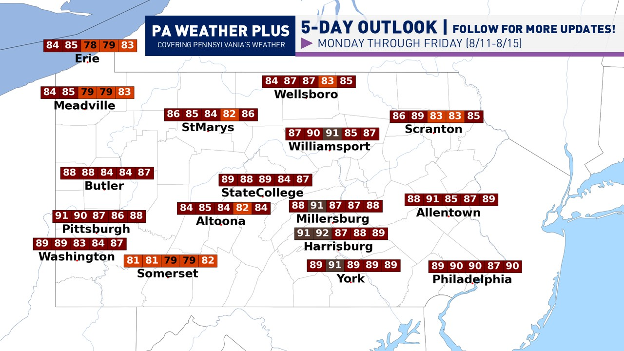
WEEKLY OUTLOOK:

MONDAY (8/11): High temperatures ranging from the mid-80s to low-90s. Expect mostly to partly sunny skies. Heat indices will range from the mid-80s to mid-90s, with the highest heat indices across western PA. Winds out of the south at 6 – 12 mph.
TUESDAY (8/12): High temperatures will range from the mid-80s to low-90s. Expect partly cloudy skies, with a low-end precipitation chance across south-central Pennsylvania and across the Laurel Highlands (less than 25% with most areas remaining dry). Heat indices will range from the upper-80s to mid-90s, highest across the southern and western tier. Winds out of the south at 8 – 15 mph.
WEDNESDAY (8/13): High temperatures will range from the upper-70s to low-90s. Expect mostly sunny to partly cloudy skies to start, although scattered showers and thunderstorms will begin to fire across the state (west-to-east) during the afternoon and evening hours (35-55% chance). A storm or two may produce gusty winds and perhaps an instance of flash flooding. Winds out of the west-southeast at 6 – 12 mph.
THURSDAY (8/14): High temperatures ranging from the upper-70s to upper-80s. Expect partly cloudy skies. Scattered showers and thunderstorms will begin to fire across the southern portions of the state during the afternoon and evening hours (35-55% chance). A storm or two may produce gusty winds and perhaps an instance of flash flooding. Winds out of the northwest at 8 – 15 mph.
FRIDAY (8/15): High temperatures will range from the low-80s to low-90s. Expect mostly to partly sunny skies. Depending on the speed of the front, if the front lags behind, a few additional showers and storms may fire across the far southern portions of PA. Winds 5 – 10 mph out of the east at 5 – 10 mph.
TOTAL PRECIPITATION:

A bit more precipitation is expected compared to last week, but overall, there is no strong signal for a drenching rainfall. These amounts may be lower and/or higher than forecasted, depending on where the heaviest storms develop during the latter half of the week. We are beginning to get a bit dry… so some rain is needed!
That is all for this week’s forecast. As I get more consistent with doing these blog posts, I hope to add more details and more graphics to help you plan for your week. If you have any questions, please PM on Facebook or email [email protected] and I will be glad to help. For a localized 2-day forecast, go to https://paweatherplus.com/your-local-weather/
-Meteorologist Denys K.