A cold front is expected to cross the state this afternoon and evening, bringing the risk for strong to severe thunderstorms. This cold front will bring ample ingredients, such as wind shear and instability, needed for the development of these stronger storms.
Severe weather or not, this rain will be much-needed for many locations across the state. While the spring and early summer months were wet with numerous flash floods, ever since a pattern flip in mid-July, it has been relentlessly dry and sunny, which is causing concern for drought across the state.
PENNSYLVANIA FUTURE RADAR TIMING:
Disclaimer: Keep in mind, these are simulated radar projections using high-res modeling and may not be exactly 1:1 to what occurs this afternoon and evening.
By lunch hour, Western Pennsylvania will be seeing mostly rain showers with a line of stronger showers and possible thunderstorms moving into central Pennsylvania. The ingredients for stronger thunderstorms will be mostly across central Pennsylvania, so this will be the line to watch for that potential. Below is the high-res model image for 12:00 PM EDT.

By the time we head into the mid-afternoon hours, the line of storms may continue to strengthen, bringing more impacts across central Pennsylvania. This may be the best timing for the strongest storms, so if you live across central Pennsylvania, this will be the time to watch for stronger storms. Below is the high-res model image for 3:00 PM EDT.

Heading into the late afternoon and evening hours, the majority of the storms will be across eastern Pennsylvania. Although with the loss of daylight and peak daytime heating, these storms may be on the weakening approach. A few additional showers and storms could be possible across western Pennsylvania, although likely sub-severe. Below is the high-res model image for 6:00 PM EDT.

Heading now after sunset, remaining showers and storms will be most prone across far eastern Pennsylvania. Although with the limited instability at this hour, most storms should remain sub-severe. Nevertheless, any storm can still produce gustier winds, heavy rainfall, and some lightning. Below is the high-res model image for 9:00 PM EDT.

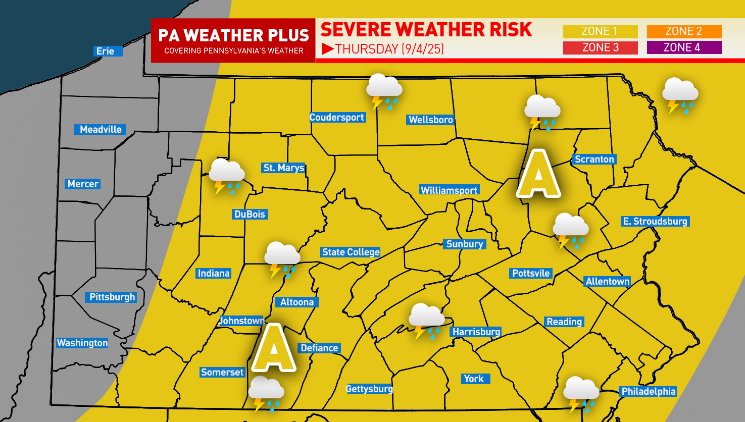
FINAL CALL PENNSYLVANIA SEVERE WEATHER OUTLOOK:

Area A: Isolated storms may produce 50–60 mph wind gusts & hail up to penny-sized.
Larger cities/towns at risk: • State College • Altoona • Johnstown • Somerset • Scranton • Harrisburg
What “isolated” means: Most spots miss out, but one or two strong storms are possible anywhere within the zone. In this zone, it is better to remain aware, especially if planning to be outdoors for prolonged periods of time.
PENNSYLVANIA RAINFALL THROUGH FRIDAY MORNING:

Overall, western Pennsylvania has trended drier while eastern Pennsylvania has trended wetter. These are the forecast rainfall amounts through Friday morning. Overall, most areas will see about 0.25 – 0.75″ of rainfall; however, if you get under a heavier storm, you could see up to an inch of rainfall.
FOR MORE UPDATES, FOLLOW US ON FACEBOOK!
Share below to spread this weather update to your family, friends, etc, to keep them weather aware!