July will end with a bang as a slow-moving cold front brings widespread showers and thunderstorms across Pennsylvania. While many are eagerly awaiting a cooldown from the recent heat and humidity, this transition won’t be easy. The slow movement of the front combined with high atmospheric moisture will set the stage for heavy rainfall, flash flooding, and even isolated strong storms. Read more information below on where the heaviest risk lies, the severe potential, and the rainfall amounts!
THE SETUP:

Here is a graphic showing the cold front that will be moving through. However, with a ridge building across the western Atlantic Ocean, this will act as a brief ‘stop sign’ and slow down the cold front. This front will then set up shop over the Commonwealth, bringing our heavy showers and slow-moving thunderstorms on Thursday.
FUTURE RADAR:
Keep in mind, this is a simulated future radar and may not exactly occur as shown. Take the future radar as potential guidance and when the best times of rain and storms may occur.

By the early morning hours, the majority of the rain should be across northern Pennsylvania. A few hit-and-miss showers cannot be ruled out elsewhere, but the majority of the risk will increase throughout the afternoon and evening hours.

By lunchtime, we will see more precipitation begin to fire up, with the heaviest still across western Pennsylvania. Those across central and eastern Pennsylvania may see a few storms begin to fire up with a few showers. As we head more into the afternoon, even more activity will begin to fire up.

By mid-afternoon, we will begin to see numerous showers and thunderstorms develop. Keep in mind, any thunderstorm will be slow-moving and have the potential to produce rainfall rates up to 2-3″ per hour, which will lead to very heavy rainfall and lead to flash flooding in as little as minutes.

By the late-afternoon and evening, numerous showers and thunderstorms will be across eastern Pennsylvania. Keep in mind, any thunderstorm will be slow-moving and have the potential to produce rainfall rates up to 2-3″ per hour, which will lead to very heavy rainfall and lead to flash flooding in as little as minutes.

Then, as we head later into the evening and overnight hours, heavy showers and thunderstorms will continue across eastern Pennsylvania. The flash flood risk may extend into the overnight hours, making for a dangerous situation to those who may be impacted and/or travelling. Remember to turn around, don’t drown! Any thunderstorm will be slow-moving and have the potential to produce rainfall rates up to 2-3″ per hour, which will lead to very heavy rainfall and lead to flash flooding in as little as minutes.
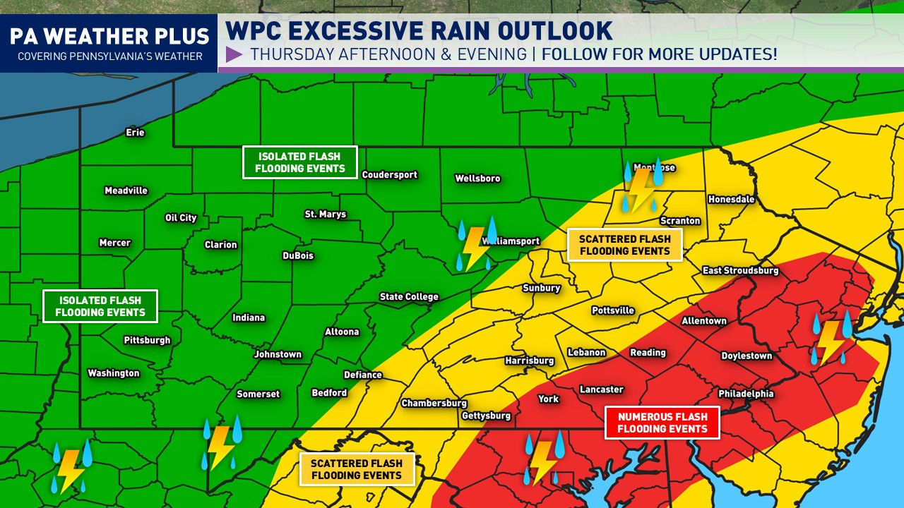
FLOOD OUTLOOK

The WPC has placed parts of the region under a flash flood risk (level 1/4 – green, level 2/4- yellow, moderate 3/4). NUMEROUS flash flood events are expected in the RED 3/4 risk. Any heavier storm may produce 2-3″+/hr rates, which will lead to flash flooding. SIGNIFICANT FLASH FLOODING IS EXPECTED IN THE MODERATE (3/4) RISK AREA. THESE RISKS ARE RARELY ISSUED FOR PENNSYLVANIA AND ONLY FOR HIGHER-END RAINFALL EVENTS. A few localized spots may see up to 4 – 7 inches of rain. Flash flooding may occur in as little as minutes in the heaviest thunderstorms. Remember to turn around, don’t drown, and heed all flash flood alerts issued tomorrow!
LARGER TOWNS / CITIES AT GREATEST RISK: Scranton, Harrisburg, Allentown, Reading, Lancaster, Philadelphia
EXPECTED RAINFALL AMOUNTS

Here is a look at the forecasted rainfall amounts and where I feel like the best risk will be for significant impacts. THESE TOTALS MAY BE UNDERDONE IN SPOTS… These are just ‘smoothed’ out generalized totals, with already amounts as high as 3 to 4 inches. Based on the latest model guidance and my intuition, I would not be surprised for localized spots to pick up 6″+, but that really cannot be determined until possibly 3-6 hours in advance. ANY STORM MAY BE ABLE TO PRODUCE FLASH FLOODING!
SEVERE WEATHER RISK

While severe weather will not be the greatest concern tomorrow, a few storms may be on the stronger side, especially well south of the cold front. This is where there will be the greatest destabilization with higher temperatures and humidity that will lead to the potential severe weather risk. Any strong storm will also be able to produce flash flooding and will likely do so.
ZONE 1 – *ISOLATED* Strong to severe thunderstorms are expected. The strongest storms may produce gusty to damaging wind gusts of 45 – 55 mph. A spin-up tornado or two cannot be ruled out. Non-severe thunderstorms may still produce heavy rainfall and frequent lightning. LARGER CITIES/TOWNS IN THIS RISK: Harrisburg, Allentown, Philadelphia
For a more detailed on the best timing for your exact location, check out https://paweatherplus.com/your-local-weather/! This is where you will get a generated forecast for your location with more precise percentages in terms of precipitation. Please stay safe tomorrow and stay tuned for additional updates.