The time is here. After tracking the winter storm all week with dramatic northward shifts, we are now within 24 hours of the beginning of one of the largest winter storms to impact the state in several winters. In fact, this is the first time since the Presidents’ Day Storm in 2003 that all 67 counties in Pennsylvania are under a Winter Storm Warning.
If you are here for the snowfall map only, press “FINAL CALL SNOWFALL AMOUNTS” to jump to the bottom of the article!
CLICK TO JUMP TO THE FOLLOWING:
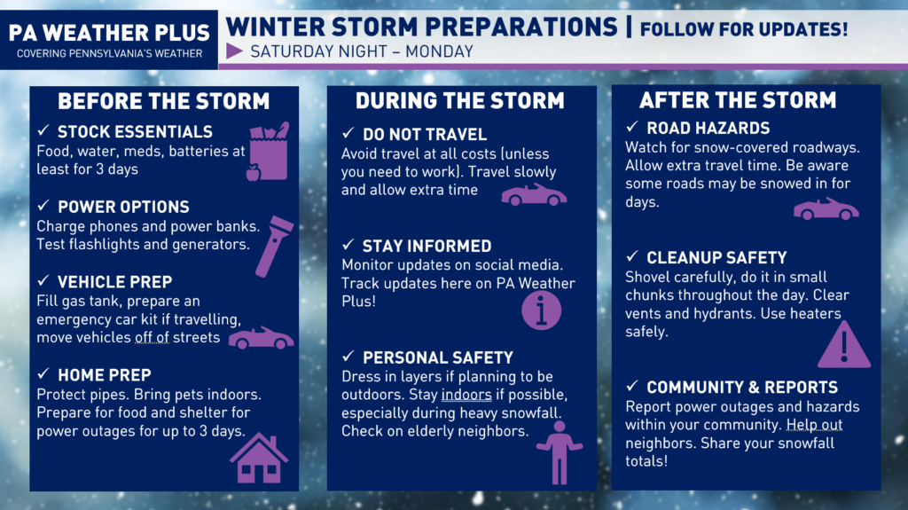
WHAT SHOULD I DO TO PREPARE?
Here are some winter storm preparation tips: Make sure you stock up on essentials like food, water, medications, and batteries, and charge your phones and power banks ahead of time. Fill your gas tank, prepare your vehicle, and avoid unnecessary travel during the storm if possible. If you are prone to power outages, make sure you have enough food and water to last at least 3 days! Stay informed by monitoring the latest forecasts and updates, use caution when shoveling snow and traveling on icy roads, and check on neighbors. Report any power outages or hazards in your community and continue to follow PA Weather Plus for updates.
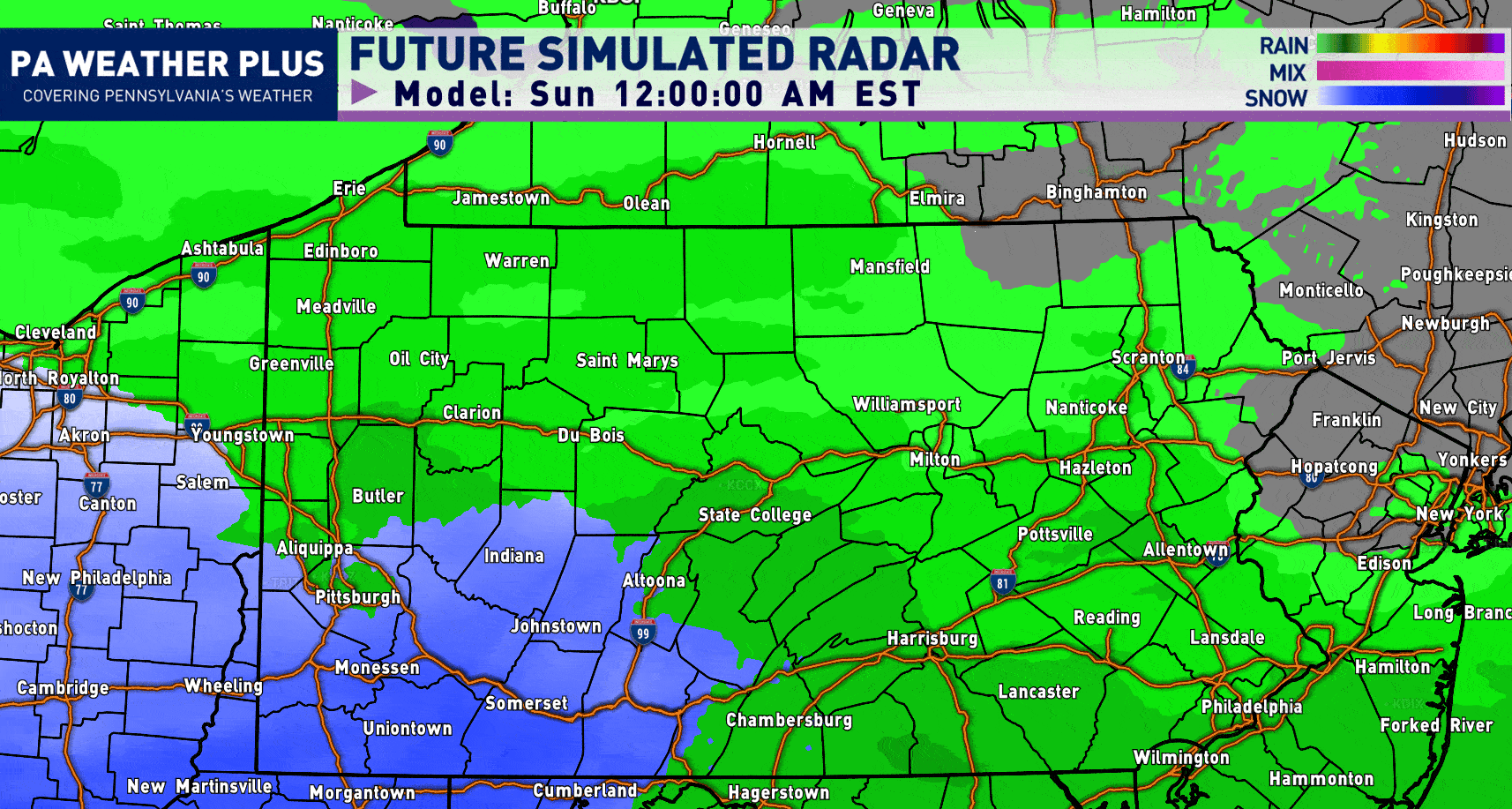
PENNSYLVANIA FUTURE RADAR SIMULATION:
Ignore the “rain” showing up ahead of the snow shield- that is an internal error on the software (it is snow “falling” but not reaching the ground due to initial dry air). The GIF below will play through in 2-hour intervals from 12:00 AM Sunday through 12:00 AM Monday.
Late Saturday Night – Sunday Morning: Light snow overspreads the state southwest-to-northeast.
Sunday Morning – Sunday Mid-Afternoon: Heaviest snowfall rates of 1-2″/hour. The mixing line begins to creep up in southeastern Pennsylvania.
Sunday Late Afternoon through the Early Overnight: Drier air begins to work in, although lighter snow continues across much of the state. Dry slotting occurs across central and eastern Pennsylvania.
Monday Morning (not pictured): Leftover snow showers and flurries possible.
I have a page on the website dedicated to giving you a more accurate timing forecast for your given location. Check it out here! Your Local Weather
WINTER WEATHER ROAD CONDITIONS:
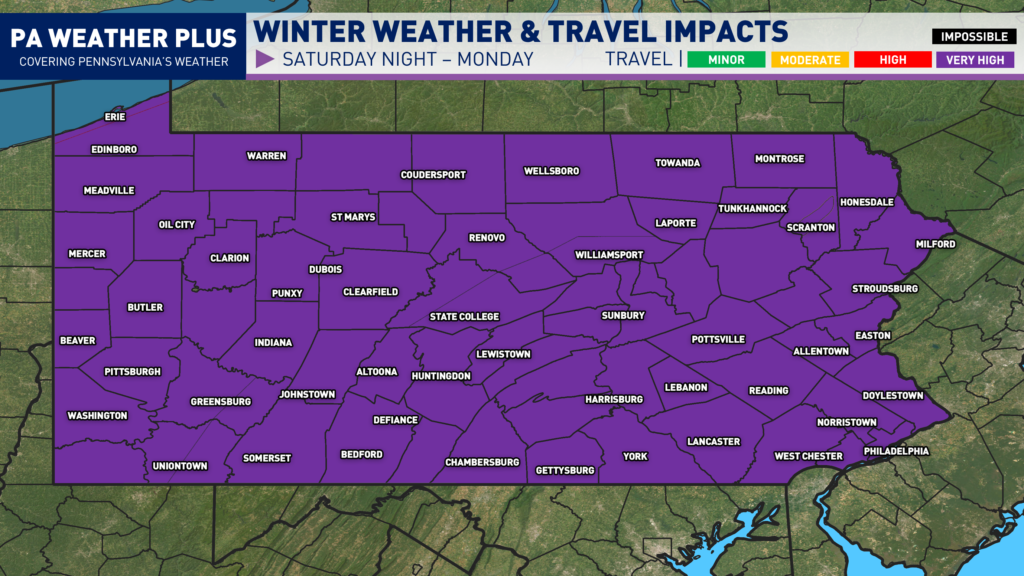
VERY HIGH: Widespread snow and/or ice will cover nearly all roadways, including major highways and interstates. Severe winter storm conditions will create extremely dangerous travel. Vehicles may become stranded, especially during the heaviest snow and/or ice. Travel will be impossible at times. Do not travel unless absolutely necessary. All Pennsylvania interstates are under a Tier-4 road restriction. All commercial vehicles are banned from travelling, beginning at Midnight on Sunday.
Public vehicles are not banned, but check out road closures on 511pa.com during the midst of the storm in case restrictions rise to the Tier-5 level (all non-emergency personnel vehicles banned).
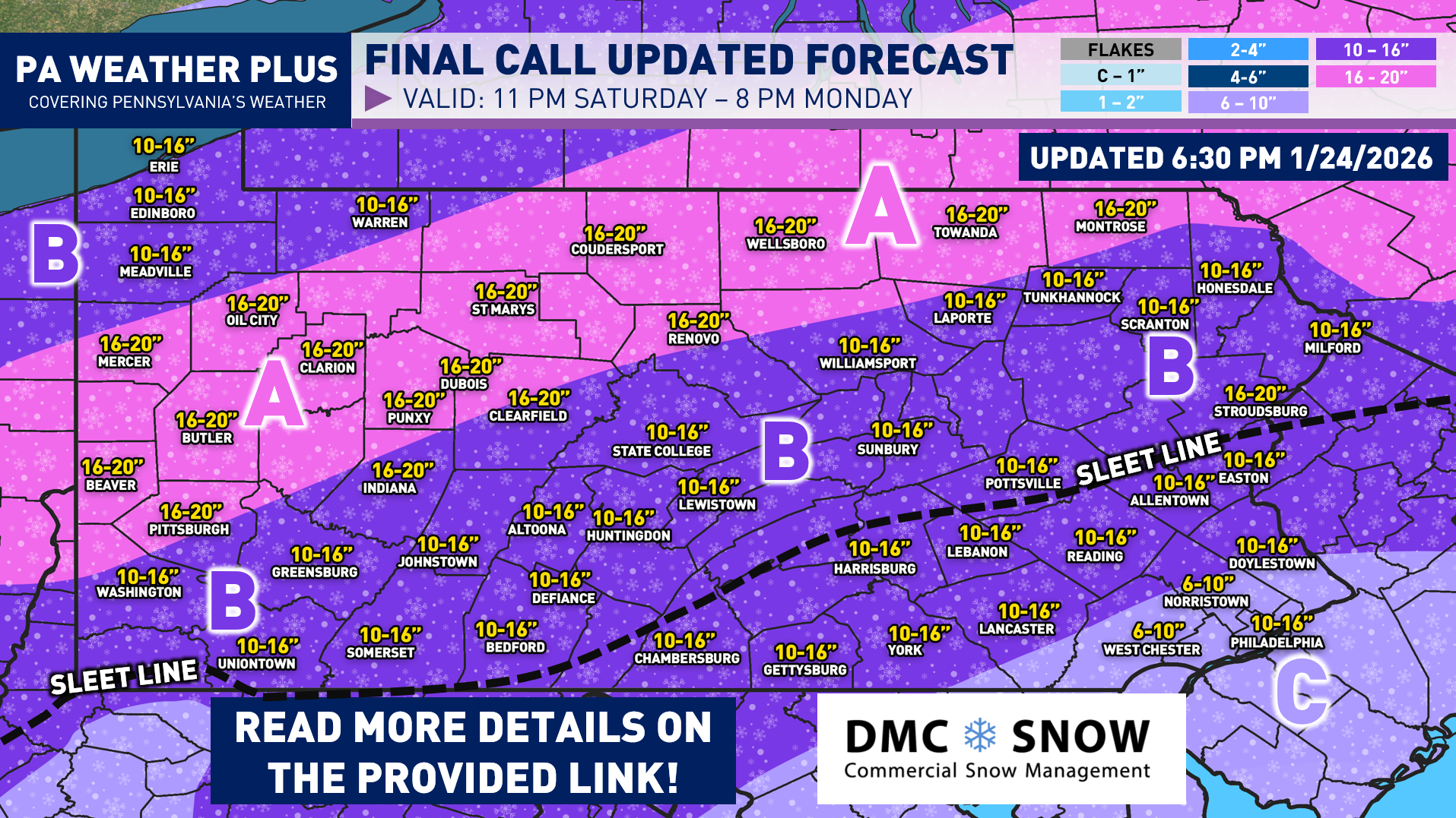
FINAL CALL SNOWFALL AMOUNTS:
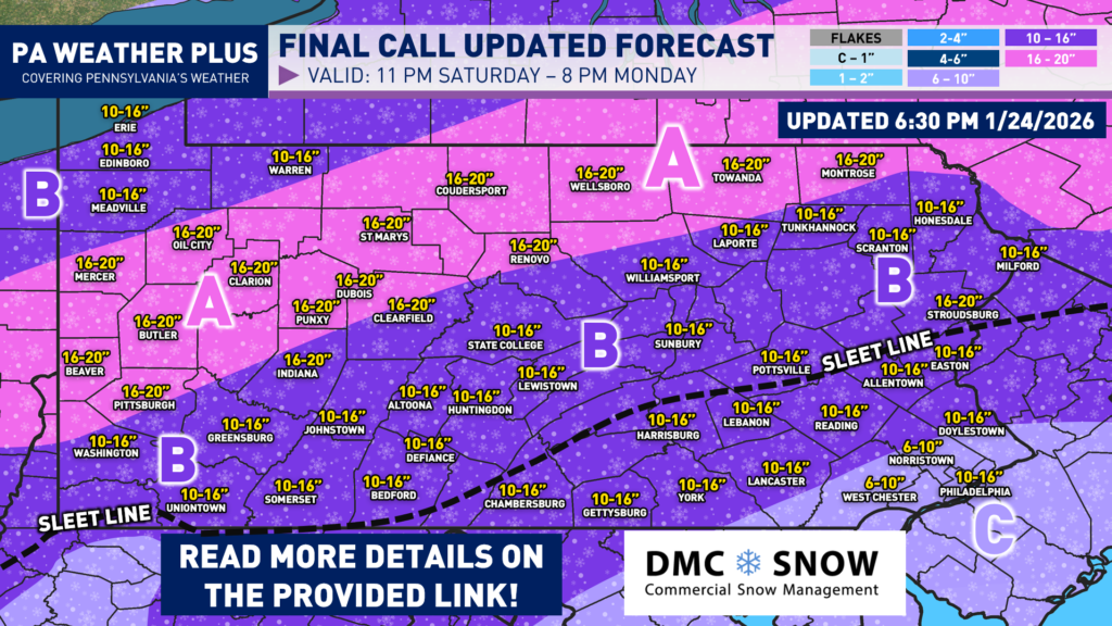
Even with the fluffier snow expected, I would expect isolated power outages to occur in isolated areas due to the weight of the snow on trees and branches. This will be increased in Areas C & D due to the heavy sleet potential. If you are prone to losing power, prepare for power outages and be prepared to be snowed in. It is recommended that you prepare enough non-perishable food and water for power outages to last for up to 3 days or longer. Arctic air will follow this storm system.
AREA A: Snowfall amounts of 16 to 20 inches. Roadway conditions will likely be impassable Sunday through early Monday morning with heavy snowfall expected. Schools and businesses will likely remain closed into Monday, Tuesday, and possibly Wednesday.
AREA B: Snowfall amounts of 10 to 16 inches. Roadway conditions will likely be impassable Sunday through early Monday morning with heavy snowfall expected. Sleet will likely mix in Sunday night into Monday morning (along and south of the dashed line). Schools and businesses will likely remain closed into Monday and Tuesday.
AREA C: Snow amounts of 6 to 10 inches. Sleet amounts up to 1 inch are possible, making for even worse travel conditions. Roadway conditions with snow and sleet combined will likely lead to very hazardous travel conditions Sunday through Monday morning. Schools and businesses will likely remain closed on Monday.
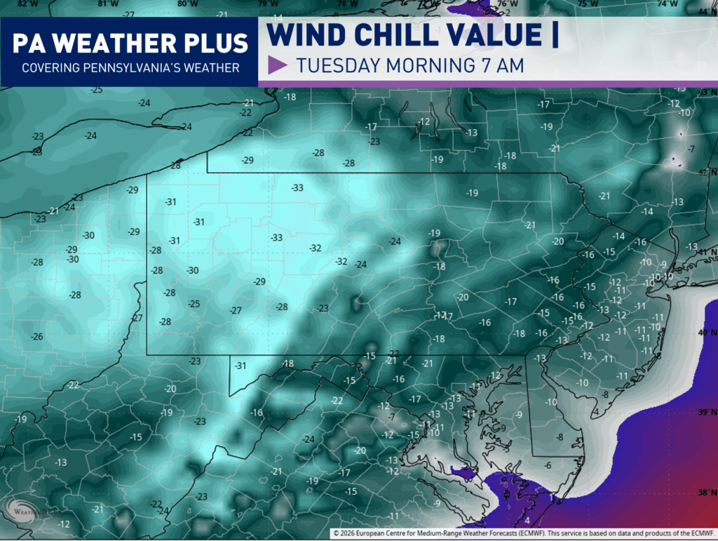
POST-STORM ARCTIC CHILL:
After the storm, current model projections bring in widespread wind chill values between -20 to -30 degrees Tuesday morning. Whatever falls on Sunday / Monday will stick around. The increased wind gusts and colder air will make post-storm cleanup efforts very difficult. Some roads may be snowed/iced in for several days. I expect many school/business closures on Monday, Tuesday, and possibly into Wednesday!
Thank you for reading! Please stay safe and warm throughout the storm tomorrow. Do not travel unless it is for work or emergency purposes. Cleanup will be slow on Monday and Tuesday so give yourself extra time and be patient. If you have any questions / concerns, please reach out and I will try to answer to you as honest and quickly as possible.
-Denys