Estimated reading time: 10 minutes
Time is flying by! We are already entering late November, which means before you know it, it will be December. December is the first month of meteorological winter. From a climatological perspective, December is the first month when large winter storms become more evident. Cold air outbreaks also start to occur. With the Christmas and holiday season around the corner, a little snow can add to the magic!
Disclaimer: Long-range forecasting is difficult. Larger atmospheric pattern changes could lead to the forecast swaying off track in either direction. This forecast was developed using the current observations, analogs, and guidance on Wednesday, November 19th.
For reference, I released a winter preview outlook for what typical weak La Nina’s bring across the country: https://paweatherplus.com/2025-2026-winter-forecast-preview/
Be winter-ready with DMC SNOW, an exclusive provider of commercial snow & ice management across Pennsylvania, New Jersey, and Delaware. From distribution centers and warehouses to office parks, shopping centers, and retail stores, we keep your property clear and business running all season long. Find more information here: https://dmcsnow.com/
JUMP TO THE FOLLOWING:
WHAT HISTORY TELLS US:
This upcoming December, we will be in the ENSO state of a weak La Niña. A La Nina occurs when the east-central Pacific Ocean waters are below average. The opposite is an El Niño (above average central Pacific Ocean water temperatures). Since 2000, several years featured a weak La Niña in December. These years were: 2024, 2022, 2017, 2016, 2008, 2005, and 2000. To predict this year’s December, it is helpful to examine what occurred in these years. This gives us insight into potential developments.
For those years listed above, the temperature anomalies were below average for much of the central and eastern United States. Pennsylvania averaged between 2 and 3 degrees below Fahrenheit.

The precipitation anomalies tell a different story. Much of the central and eastern United States observed below-average precipitation and was drier than average. The strongest signal for wetter conditions appears in the central Rockies. It is also present in the northern Plains and the interior Northeast. Pennsylvania averaged to be near to below average. Keep in mind, below-average precipitation does not necessarily mean less snowfall. Total precipitation accounts for the liquid equivalent of snow, sleet, and rain.

From historic weak La Nina winters, Pennsylvania tends to experience below-average temperatures and below-average precipitation.
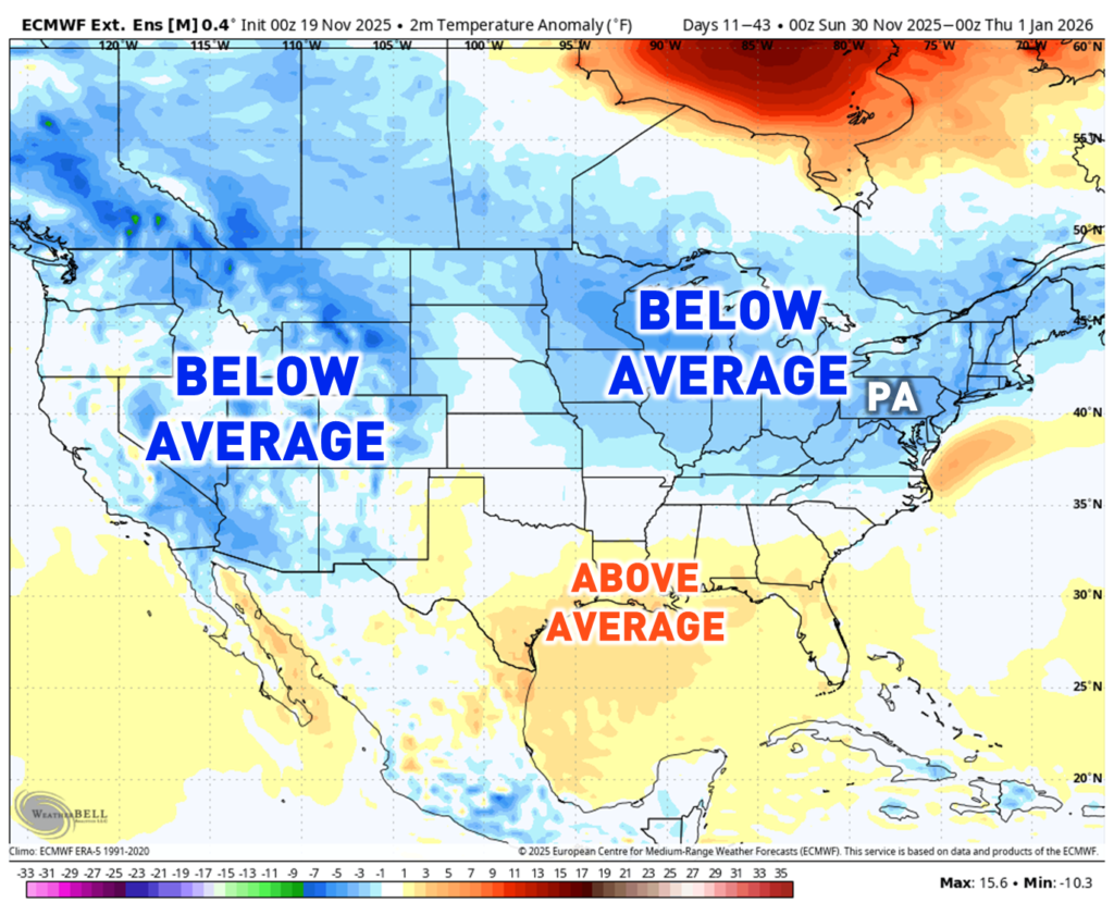
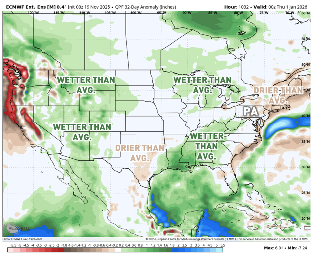
CURRENT LONG-TERM MODEL GUIDANCE:
The extended European Model Ensemble Suite is being shown. There are some differences across different portions of the United States. However, the story holds the same in Pennsylvania. Model guidance is backing the ideas for below-average temperatures and near to below-average precipitation across Pennsylvania. I noticed a key detail. There is a wetter-than-average signal across the south-central United States. This could indicate a potential active storm track out of the Gulf.
DECEMBER PROJECTED TELECONNECTIONS:
Teleconnections are different weather patterns across the globe, with those listed below primarily in the Northern Hemisphere. They are tracked in positive and negative phases, depending on the anomaly. These phases have large impacts on the pattern here in Pennsylvania and the United States.
NORTH ATLANTIC OSCILLATION (NAO): Leaning Negative/Neutral. This will lead to high-latitude blocking at times throughout the month of December. This will help to ‘lock in’ colder blasts of air into the eastern United States. If timed perfectly, it could increase the risk for a larger storm.
ARCTIC OSCILLATION (AO): Negative to Neutral: This will lead to blocking across the Arctic regions. This increases the risk for cold air blasts to infiltrate into the central and eastern United States.
PACIFIC NORTH AMERICAN OSCILLATION (PNA): Leaning Negative. This leads to more troughing across the western United States / North America. This usually leads to a less amplified pattern across the Eastern United States. It may even induce ridging across portions of the southeastern United States.
MADDEN JULIAN OSCILLATION (MJO) : PHASES 7 THROUGH 2. The MJO is different from the other teleconnections. It is numerically ordered as it tracks thunderstorm activity across the equator. This tracking occurs primarily from the Indian to eastern Pacific Ocean. It makes a full cycle every 30 – 90 days from Phase ‘1’ through Phase ‘8’. For us, the phases are favored to bring below-average temperatures to much of the eastern United States. Phases 8, 1, and 2 are favored cold. Phase 7 is a transition phase.

IS THE POLAR VORTEX COMING?
First of all, what is the polar vortex? The polar vortex is a large pool of extremely cold air that spins like a vortex. It sits high up in the atmosphere over the North and South Poles. For our case, we are looking at the North Pole. It is roughly 19 – 20 miles above the ground.
There has been a lot of hype regarding the polar vortex recently. This is because the polar vortex is currently experiencing a significant warming event with a possible wind reversal. A significant weakening of the polar vortex with a wind reversal raises a red flag. It could lead to a polar vortex disruption. Polar vortex disruptions help to spill colder air into the mid-latitudes.
Remember, the stratospheric polar vortex is not felt at the surface, it is miles up over the North Pole. However, it can impact and connect with the troposphere (which is the weather we feel at the surface) and can send intrusions of arctic air. Whether this actually occurs is up for debate, but it is helping to lean colder for the December temperature outlook. Beware of the hype you see online!

This is a better graphic from NOAA. It shows the difference between a stable polar vortex and one in a weakened state. The polar vortex is currently in the disrupted phase. Typically, it takes 20 to 30 days to feel the effect down at the surface. The disrupted polar vortex will play a significant role in the pattern by mid-December. It may help to push Arctic air into the United States. Pennsylvania could see impacts from this disruption, although there remains to be a lot of uncertainty.

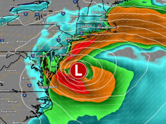
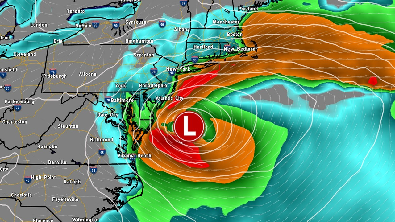
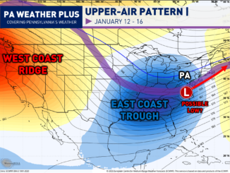
POTENTIAL STORM TRACKS:
This is where I am probably least confident in the forecast, so bear with me. Given the typical La Niña pattern, I believe we will see a lot of zonal west-to-east storm tracks. West-to-east tracking storms are normally less strong, due to less amplification. However, some subtle southeast ridging is expected. There is the potential for a stronger system or two to flavor into the mix. These stronger systems will likely include the potential for warmer air to infiltrate into southern Pennsylvania. There is also a better risk for wintry precipitation I-80 and northward. This includes typical “Cold Air Damming” zones.

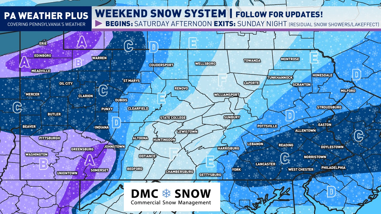
PENNSYLVANIA 2025 DECEMBER OUTLOOK:
TEMPERATURE FORECAST:

AREA A : Multiple sustained blasts of colder air are expected. Overall, December temperatures should average out 2 to 4 degrees below average. Watching the potential for one stronger Arctic blast mid-to-late month if we see impacts from the polar vortex disruption.
AREA B : A few sustained blasts of colder air are expected, although some mitigation is expected with some influence of the southeastern ridge. December temperatures should average out 1 to 2 degrees below average. Watching the potential for one stronger Arctic blast mid-to-late month if we see impacts from the polar vortex disruption.
PRECIPITATION FORECAST:

Reminder: Precipitation equals the total liquid equivalent of rain, snow, sleet, and hail.
AREA A: Above-average precipitation is likely with several lake-effect events. 125 to 150% of the average precipitation forecasted.
AREA B: Near to above average precipitation is expected with several lake-effect events streaming farther from Lake Erie. 100 to 125% of average precipitation forecasted.
AREA C: Toss-up. La Niña does not favor a lot of larger precipitation storms in December, but we could squeeze one or two in during periods of high-latitude blocking. 85 to 115% of average precipitation forecasted.
SNOWFALL FORECAST:

AREA A: Well above average snowfall is expected with the potential for one or two larger lake effect events within stronger blasts of cold air. 150 to 200% of the average snowfall forecasted.
AREA B: Above average snowfall is expected with lake effect and the potential for a few storms to track through. Areas farther north will be favored for higher snowfall due to colder air, especially with west-to-east sliding storms favored areas north of I-80. 125 to 150% of the average snowfall forecasted.
AREA C: Leaning above average for snowfall. With a few west-to-east tracking systems, colder air will be hanging around I-80 with the potential for increased Cold Air Dammning across eastern Pennsylvania. 100 to 125% of the average snowfall forecasted.
AREA D: Toss-up region. With some west-to-east tracking storms, we will likely see a few mixed precipitation events. If we see a colder period with a larger storm, less mixing could occur. 85 to 115% of average snowfall forecasted.
AREA E: Likely leaning below average snowfall-wise. There will be a blast of colder air. However, the front end of these systems will likely be favored for rain or mixing events. 65 to 85% of average snowfall forecasted. Note: One bust factor could occur if a larger storm couples in during a stronger cold period. This coupling would increase the snowfall potential.
Quick Summary:
- Likely trending colder with favorable pattern with background ENSO state of a weak La Nina.
- Generally west-to-east “flatter” storm pattern, not very favorable for larger coastal storms.
- Polar vortex disruptions may allow for a stronger cold air blast, preferably mid-month.
- Increased risk for heavy lake effect snowfall.
- Best chance for above average snowfall I-80 and northward, where there is less concern for mixing.
THANK YOU! Thank you for taking your time to read this! I personally don’t like making seasonal forecasts as they are hard to verify. Small changes in the pattern can throw off an entire long-range forecast. This is why I decided to do forecasts month by month throughout the winter. I aim to get a better and hopefully more accurate picture. We will see what this month brings to our weather. I will do a verification score with a January 2026 forecast later in the month. Stay tuned for forecast updates on social media!
150K Followers
-Meteorologist Denys K