

Estimated reading time: 5 minutes
The one million dollar question every single year: “Will I see a White Christmas?” It is one of the few days of the year when winter lovers and haters come together to enjoy a day of snow! I mean, who doesn’t want to wake up to a winter wonderland on Christmas while unwrapping presents? Unfortunately, the odds this year do not favor a White Christmas for much of Pennsylvania.
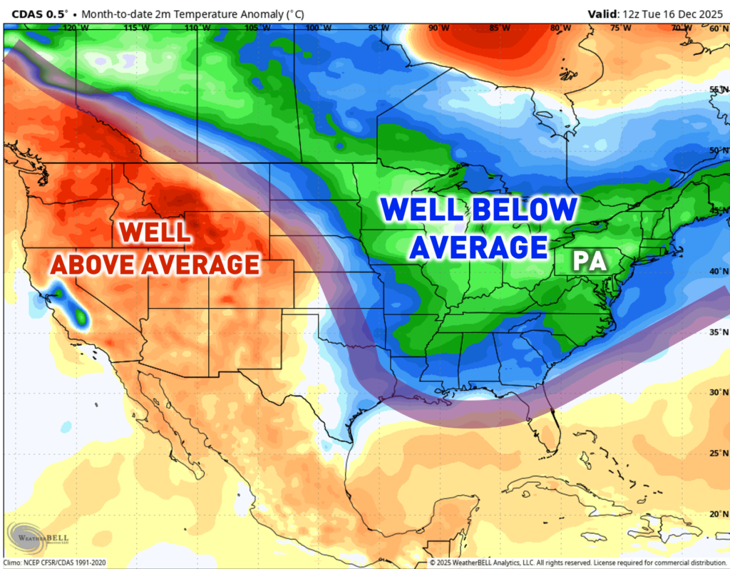
DECEMBER PATTERN SO FAR:
As forecasted in my December 2025 Outlook (read here), December was forecast to be pretty cold and snowy. As of December 16th, this has been well-forecasted (actually even colder and snowier than my forecast). This is because a ridge across the western United States has balanced out with an eastern United States trough. This has allowed for an active (albeit “weak”) storm pattern and prolonged blasts of cold, arctic air.
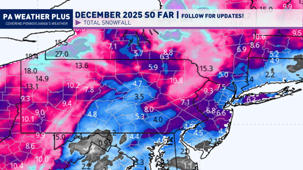
Not only has it been cold, but it has been quite snowy! Here are the *estimated* snowfall amounts to date this month. Much of western and eastern Pennsylvania has been lucky enough to get several systems. This has added up to over 6 inches, to as much as 2 feet of snow. Areas across central Pennsylvania have been on the unlucky side of the action, although still receiving light to moderate snowfall amounts.
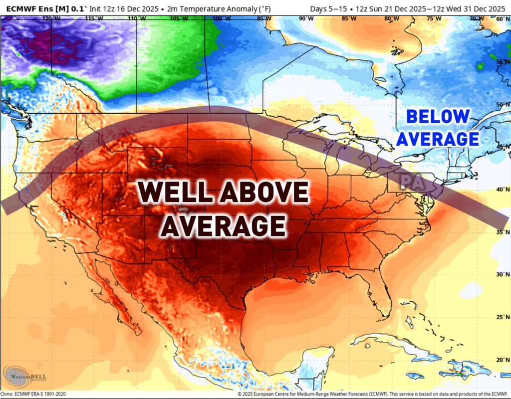
EXPECTED PATTERN CHANGE:
As we head into the final part of December, a massive pattern shift is expected. The ridge across the western United States will move eastward. It will set up across the central United States. Instead of the jet stream well south of Pennsylvania, it will likely cut right through the state. This will allow the Northeast to escape the bulk of the thaw. With the jet stream through Pennsylvania, this will set us up for a potential active storm (albeit “weak”) track, beginning around Christmas and through the New Year. Whether you see snow or rain will be very dependent on the temperature gradient around each passing storm.
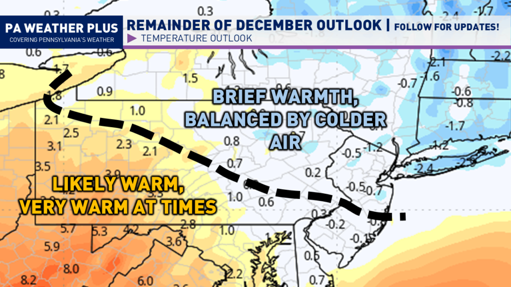
Taking a closer look, you can see how Pennsylvania will be divided almost in half diagonally. Much of southwestern and western Pennsylvania is likely to bask in warmth, at times very warm, through the end of December. As you head north and east, blasts of colder air will still be common, although they will be broken up with periods of short-term warm days. This will have a significant impact on the White Christmas Forecast!
WHITE CHRISTMAS OUTLOOK:
According to the National Weather Service, the definition of a White Christmas is for at least 1″ of snow to be observed at 7 AM on Christmas morning. Given the upcoming pattern and potential storm tracks, here is what I expect as of the forecast created on Tuesday, December 16th.
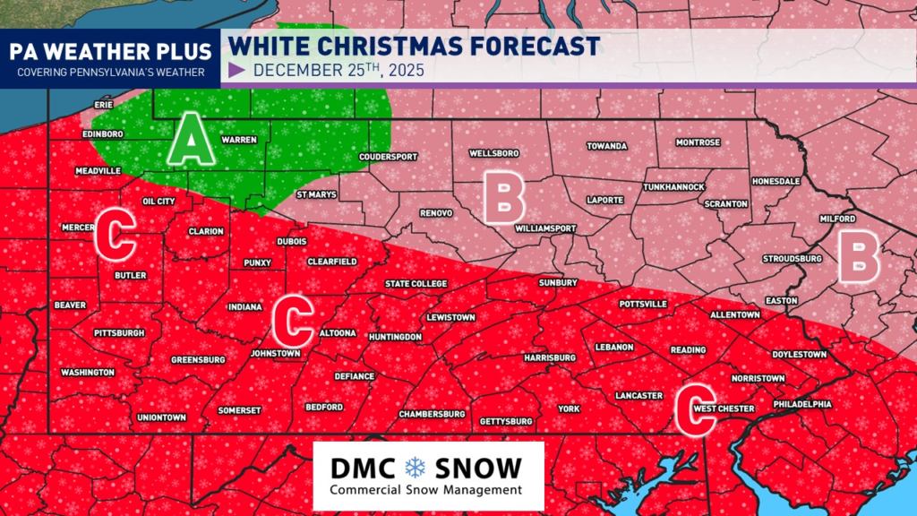
AREA A: With a deep snowpack and potentially more lake-effect snow this weekend, combined with near-average temperatures through late December, it is very likely that at least 1 inch of snow lingers on the ground for Christmas morning. This snowpack could be reinforced by the system on the 23rd – 25th, assuming it will be cold enough to snow.
AREA B: Very unlikely, but not *completely* ruled out. I am watching for a potential northwest-to-southeast sliding system that could bring accumulating snow sometime between December 23rd and 25th. If this occurs before Christmas and it is cold enough, the White Christmas chance will increase. If the storm system does not happen or it tracks too far north and brings rain instead of snow, a White Christmas will not occur. This region has a 15-20% probability of a White Christmas, so a Christmas miracle is needed!
AREA C: A White Christmas is not expected. Unless we see a significant pattern shift (which is growing unlikely) the remaining snow pack is expected to melt, and I am expecting the December 23rd – 25th system to track too far north, allowing for precipitation to fall as likely rain versus snow, cancelling the odds for a White Christmas. It will take a Christmas miracle for one to occur!
I guess you can call me the “Grinch” for this forecast, and I apologize. At the end of the day, I am just here as a messenger! For the pattern beyond late December, I will begin to put together the January 2026 outlook over the upcoming days and will hopefully release it in the final days of December. But for an early sneak peek, it does not look as cold (at least relative to average) as December has been so far. Despite the weather, I wish you all a wonderful holiday and a joyous Christmas season!
Stay tuned for updates!
150K Followers
-Meteorologist Denys K
