Round one of two CMEs that arrived on Tuesday evening produced a spectacular G4 Solar Storm, with Northern Lights seen by the naked eye across Pennsylvania (for those who got lucky with clear skies). Last evening was just an appetizer as the main and strongest CME is slated to arrive Wednesday afternoon and evening. The Space Weather Prediction Center has issued a rare G4 Severe Solar Storm Watch for November 12th evening – early morning November 13th. Read below for all of the details and the viewing conditions for Pennsylvania and the Northeast! The letter categories are defined in PENNSYLVANIA PRELIMINARY VIEWING FORECAST.
JUMP TO THE FOLLOWING:
DISCLAIMER STATEMENT
Solar weather is difficult to predict, so be prepared to set up for disappointment. It is possible the CME arrives earlier than projected, or later than projected, or never arrives at all! You should view the Northern Lights away from any light pollution. Use long-exposure cameras and night mode to best pick up the colors. During stronger substorms, you will be able to see all of the colors, but best away from cities and light pollution!
**Traveling long distances is not recommended (high risk, although high reward). **
SEVERE SOLAR STORM OUTLOOK
Here is a United States graphic showing where the Northern Lights could be visible Wednesday evening through Thursday morning. Much of the United States is included in the potential, if G4 solar storm conditions occur. The Northern Lights will be visible to cameras across the far southern United States.

DISCLAIMER MUST READ: Solar weather is difficult to predict so be prepared to set up for disappointment. It is possible the CME will arrive earlier than projected or later than projected or never arrive at all! The best place to view the Northern Lights is away from any light pollution. Long-exposure cameras and night mode will best pick up the colors. During stronger substorms, you will be able to see all of the colors. It’s best to view them away from cities and light pollution!
NORTHEAST CLOUD FORECAST TIMELINE
After sunset on Wednesday, clouds are likely across much of Pennsylvania and the Northeast. Northwesterly flow will allow for clouds to develop from the Great Lakes. For the best clear skies earlier, you will have to dip south. The best chance to view Northern Lights early in the night will be to head south, not north.

By the evening and early overnight hours, the clouds will continue to hold in most places. With downsloping flow off the mountains, those on the eastern side of the cloud extent will begin to slowly erode. Much of the interior regions will continue to be stuck under heavy cloud cover.

For the remainder of the night, the eastern cloud extent will continue to slowly get more erode. However, the interior regions that were under clouds will continue to stay under the clouds. Not a good sign if you want to view the Northern Lights from the Great Lakes or the interior Northeast!

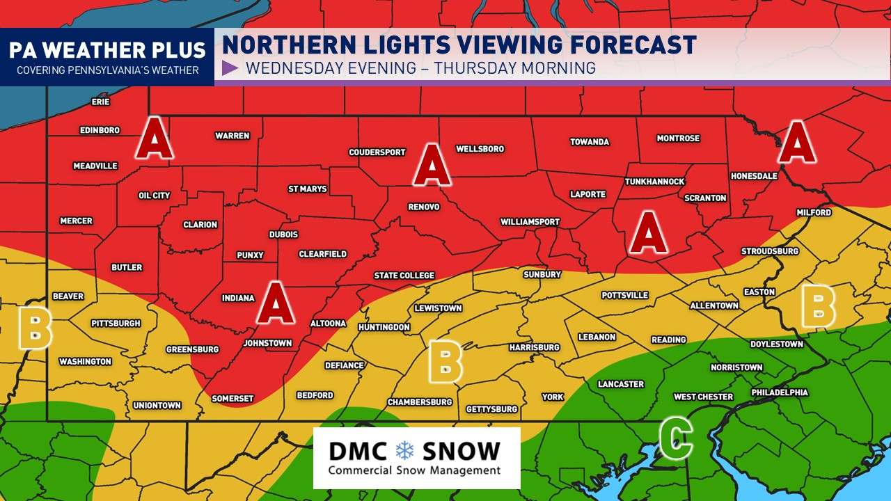
PENNSYLVANIA PRELIMINARY VIEWING FORECAST
NOTE: This viewing forecast is solely based on cloud cover and precipitation. To be able to see the auroras, you will need a good view of the northern horizon, away from heavy light pollution. **YOU WILL NOT SEE AURORA IN HIGH-LIGHT POLLUTION REGIONS.** Smartphones & digital cameras will best pick up on the Northern Lights. Your eyes will need to adjust to the dark for at least 30 minutes as well.

AREA A: Thick cloud cover and/or precipitation will hinder viewing conditions for the majority of the night. It is highly unlikely that cloud cover forecasts will improve before the solar storm event. An isolated break or two of clouds may be possible later into the night the farther you are away from Lake Erie and closer to Area B.
AREA B: Areas of clouds expected, with some thinning possible in the middle to latter parts of the night. Clouds are forecasted to thin out southeast-to-northwest. Overall, poor to fair viewing conditions are expected. It will be risky for viewing and the farther south & east you drive, the better chances for clearer skies.
AREA C: Little to no cloud cover expected. Spectacular viewing conditions. Although this area does include the city of Philadelphia, you will have to head away from city lights for the best viewing conditions.
BEST TIMING: DUSK – 4 AM (localized sub-storms may increase viewing; these are unable to be forecasted in advance)
Feel free to share with friends and family! I will have more updates throughout the remainder of the afternoon and evening regarding this potential Northern Lights event. It is always an exciting time!