When meteorologists say, “if you hate the weather, wait 5 minutes, and it will change”, this quote will be taken literally tomorrow. This is because a strong cold front is expected to cross the state. Ahead of the cold front, expect humid and warm conditions as temperatures will surge into the 40s and 50s with southerly flow. Behind the front, we will see westerly flow as temperatures drop into the 20s and 30s, allowing for snow to return. Get ready to ride a “weather rollercoaster!”
JUMP TO THE FOLLOWING:
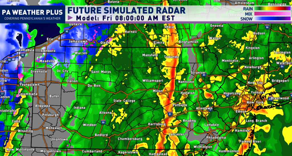
FUTURE RADAR TIMING:
During the early Friday morning hours, the squall line will be moving through western Pennsylvania. Much of central and eastern Pennsylvania will be soaked in the steady rainfall.
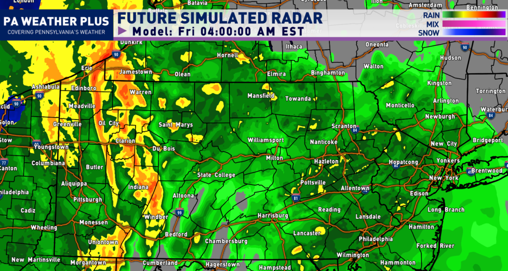
Heading into the morning commute, the squall line will begin to take shape west of the I-81 corridor. This will begin to strengthen, with wind gusts of 40 – 50 MPH and heavy downpours. This squall line is currently not expected to turn severe.
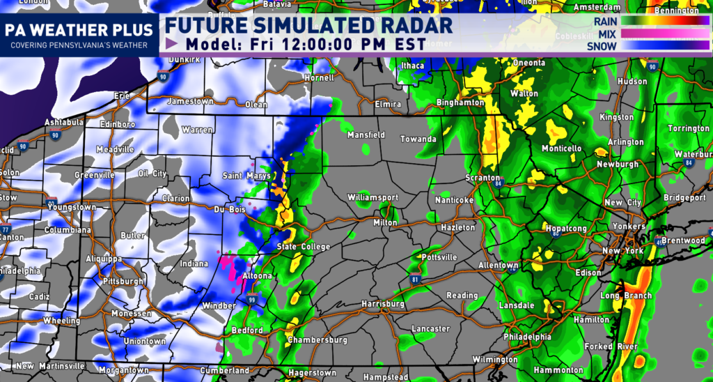
By lunch hour, the squall will have passed well to our east with cold air beginning to filter on the backside. Snow showers and snow squalls will begin to impact much of western Pennsylvania as temperatures will begin to drop below freezing.
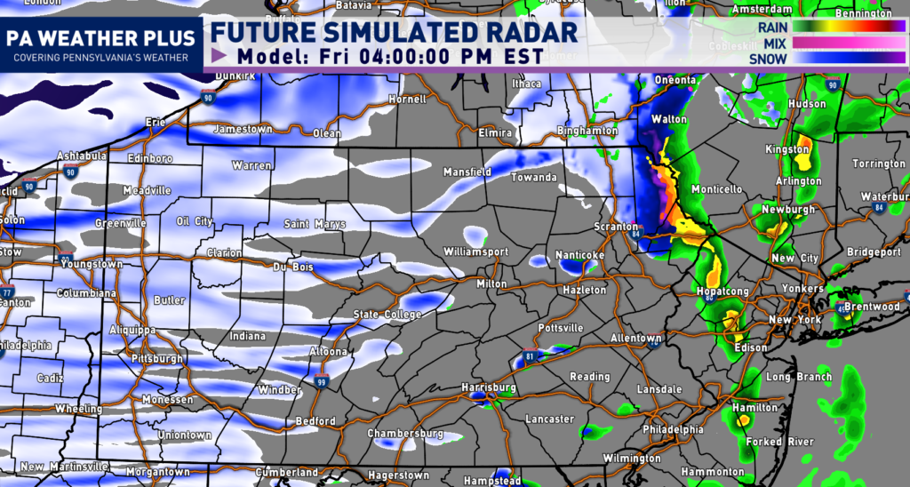
By the middle to latter parts of the afternoon, much of western and central Pennsylvania will feel the impacts of the snow showers and snow squalls. A few of these snow showers could move into eastern Pennsylvania. Snow squalls may produce dangerous driving conditions with lowered visibility and brief heavy snowfall rates, leading to coatings on all roadways.
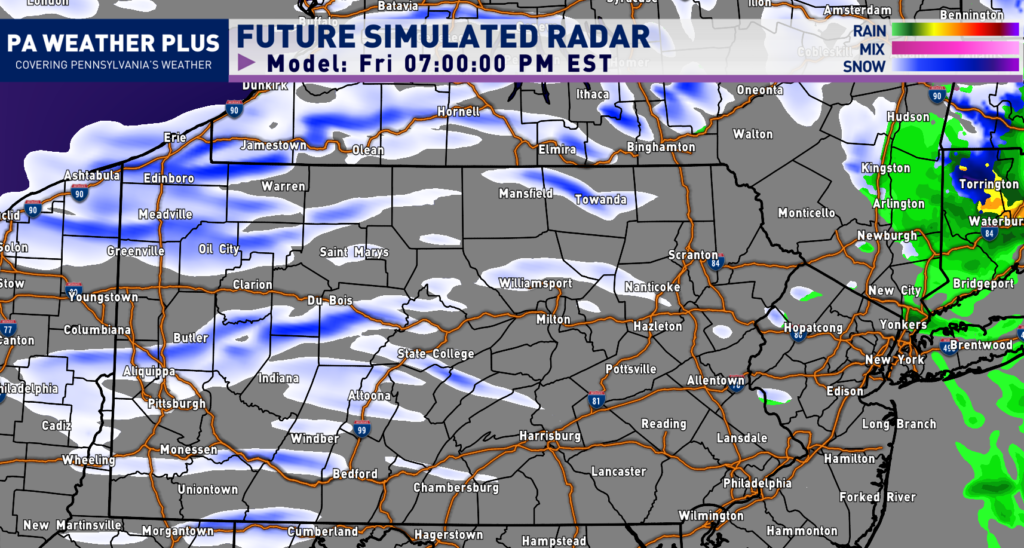
Snow showers and squalls will continue into much of western Pennsylvania into Friday evening, with additional lake-effect snow expected across the northwestern portions of the state. With much colder temperatures, expect snow-covered roadways under any heavier snow shower or snow squall.
DROPPING TEMPERATURES:
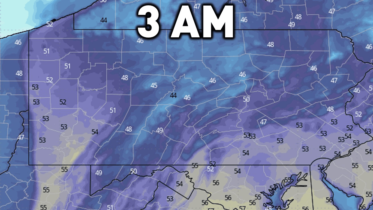
Here is a GIF showing the falling temperatures from the morning hours through the afternoon. Please let the animation of the temperatures with the time on top play through.
SNOW SQUALL SAFETY:
What is a snow squall? A snow squall is an intense, short-lived heavy burst of snowfall accompanied by gusty winds. Think of them as thunderstorms without the rain. Some intense snow squalls may have lightning! Squalls this afternoon may produce a quick half inch to an inch of snowfall in as little as 30 minutes.
Why should you care? Snow squalls are VERY dangerous when it comes to travel, especially on interstates. Snow squalls have had a history of producing multi-car pileups on interstates in past years across the state.
Within a snow squall, be on alert for RAPIDLY deteriorating conditions in as little as MINUTES. Even if road conditions are wet prior to the squall, a flash freeze may occur and make for very slick conditions. Snow squalls may lead to chain-reaction accidents and very hazardous travel.
What should you do if you are caught in a snow squall? Get off the highway. Consider an alternate route or delaying your travel. Reduce your speed and turn on your headlights. If you are caught in a multi-vehicle pileup, DO NOT stand outside of your vehicle or on the roadway.
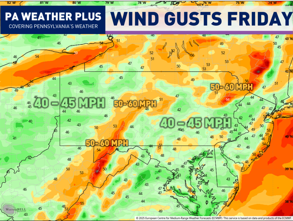
MAXIMUM WIND GUST FORECAST:
Wind gusts will be strong with the squall line that passes through, but they will be strong *behind* the cold front. The mass of arctic air rushing in will also cause for high wind gusts throughout the day on Friday. Expect widespread wind gusts of 40 – 45 MPH with the higher elevations of central and northeastern Pennsylvania gusting upwards of 50 – 60 MPH.
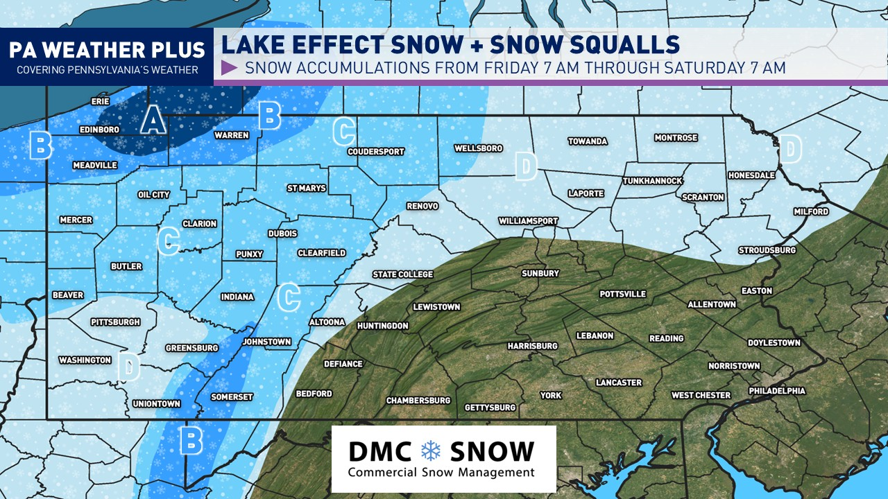
FORECASTED SNOWFALL AMOUNTS:

AREA A: 4 to 8 inches of snow expected with isolated higher amounts. Expect heavy snow squalls and lake effect bands at times Friday afternoon through the overnight hours, causing treacherous travel.
AREA B: 2 to 4 inches of snow expected. Expect times of heavy snow squalls on Friday afternoon and through the overnight hours. Watch for snow-covered roadways. Before travelling, check the road and weather conditions.
AREA C: 1 to isolated amounts of 2 inches of snow expected. Watch for briefly snow-covered roadways. Before travelling, check the road and weather conditions.
AREA D: Less than an inch of snow expected. Although higher accumulations are not expected here, be on the lookout for heavy snow showers and squalls reducing visibility and causing brief hazardous road conditions.
Get ready for the weather rollercoaster tomorrow! From morning humidity and rumbles of thunder to afternoon snow showers and snow squalls. Take it easy if you are planning to travel. As always, if you have any questions, feel free to reach out or message me on Facebook.
-Meteorologist Denys K.