I have been hearing for years, “When is the big one coming”? Well, folks, this pattern is what you have been waiting for years or decades. The biggest major winter storm forecast of my lifetime (I am 23 years old) is approaching us this weekend, bringing major impacts to much of Pennsylvania. Hurricane hunters have flown into the storm system over the Pacific overnight, gathering great data to ingest into model guidance. This has led to a large shift toward a more northerly and amplified storm system.
Blog post regarding this storm from Tuesday Morning: https://paweatherplus.com/growing-potential-for-mid-atlantic-major-winter-storm/
JUMP TO THE FOLLOWING:
OVERALL METEOROLOGICAL PATTERN:
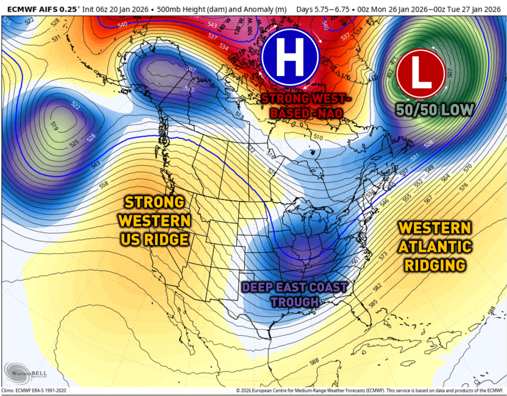
The overall pattern from a meteorology perspective is the pattern you look for ahead of intense winter storms. All of the ingredients that meteorologists look for at 500 MB are lining up. A 50/50 low combined with a strong west-based negative NAO block. Additionally, a strong western ridge will allow for the East Coast trough to dig into the southeastern United States. Western Atlantic ridging will allow for the pattern to slow down, and we get a low-pressure system to develop on the East Coast.
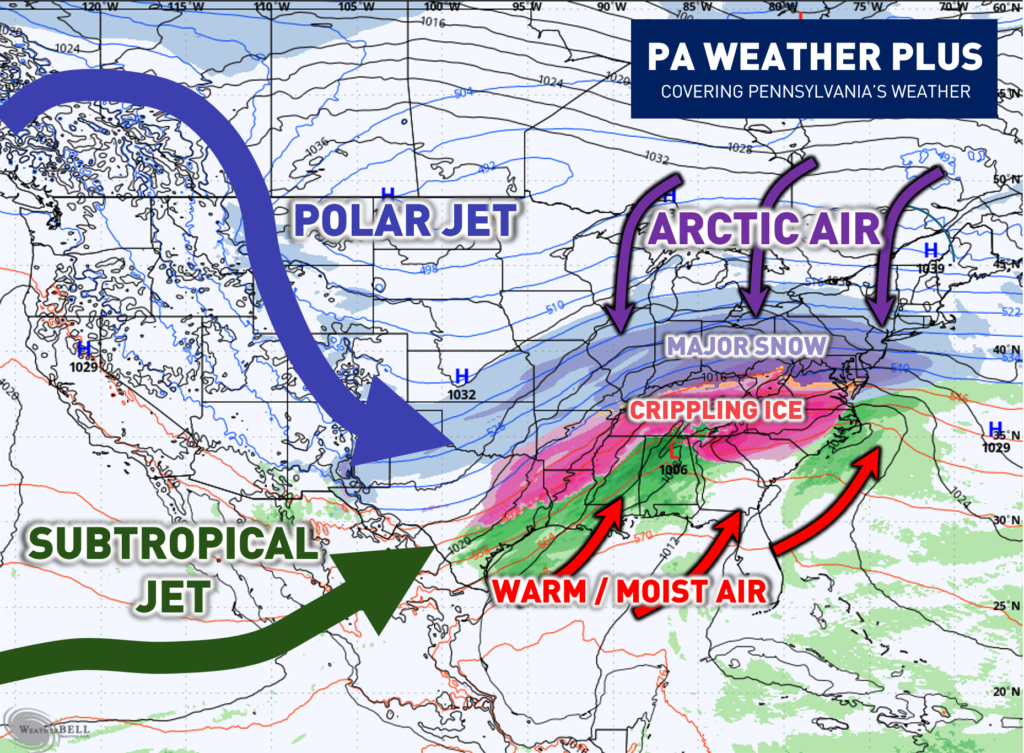
With all of the ingredients coming together, this is what will possibly look at the surface. You have your polar jet stream phasing in with the subtropical jet stream, allowing for colder air to phase in with a warm/moist airmass. Arctic Air will be filtering on the East Coast, allowing for major snow and crippling ice storms across much of the country from Texas through the East Coast. For us here in Pennsylvania, we will need to watch how the storm gains latitude throughout the weekend.
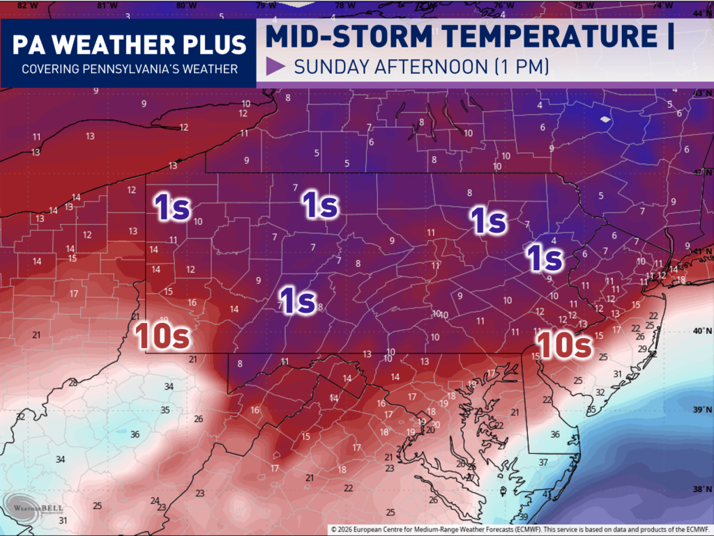
MID-STORM TEMPERATURES:
The bad aspect of this storm will be the temperatures. Temperatures during the “worst” part of the storm are currently projected to be in the single digits to lower-teens. Any pre-salting and pretreatment will likely not work at all, and all roadways and interstates will need to be assumed snow-covered. I would not be surprised by very heavy travel restrictions incoming with this storm.
EARLY TIMING OUTLOOK:
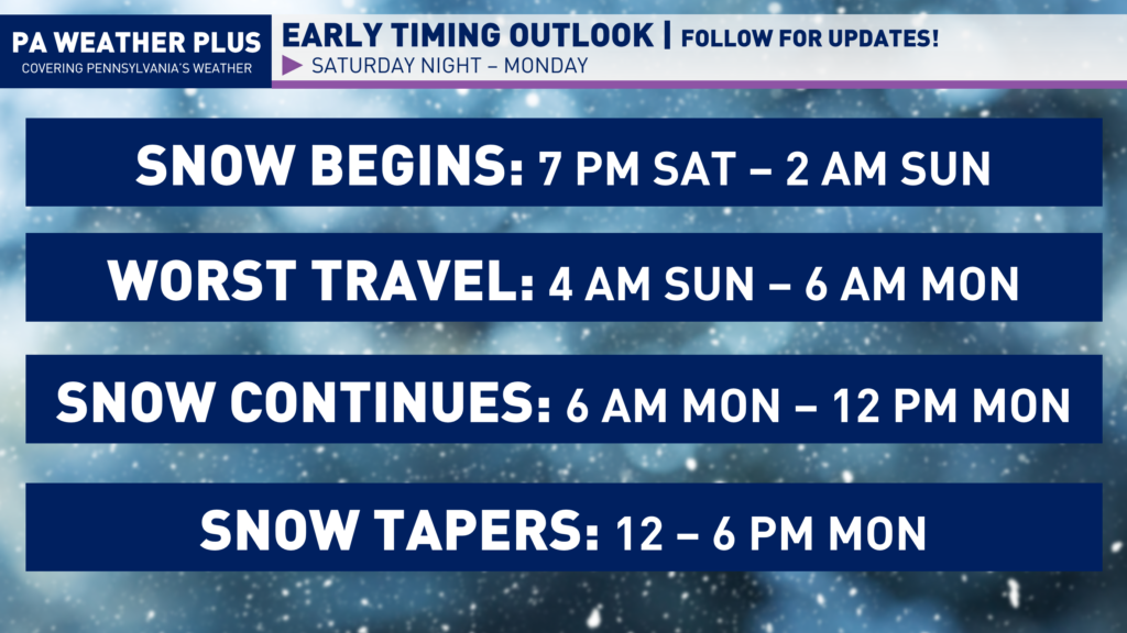
Snow will be moving into Pennsylvania southwest-to-northeast Saturday evening through early Sunday morning. Once the storm begins, the conditions will worsen quickly. All day on Sunday will likely have very hazardous to at times impossible travel conditions with bands of heavy snowfall. The snow looks to continue into Monday morning before tapering off Monday afternoon. If you have travel plans Saturday night through Monday morning, it is now time to think of backup plans or likely consider rescheduling. This timing graphic will work out with all scenarios.
WINTER STORM SCENARIOS:
“GENERAL” SNOWFALL CATEGORIES: MODERATE: 3″+, SIGNIFICANT: 6″+, MAJOR: 12″+, CRIPPLING: 18″+
NOTE: These are not “snowfall” maps exactly, but these categories are used to better explain the potential scenarios. I would ignore snowfall amounts on any weather app until Thursday.
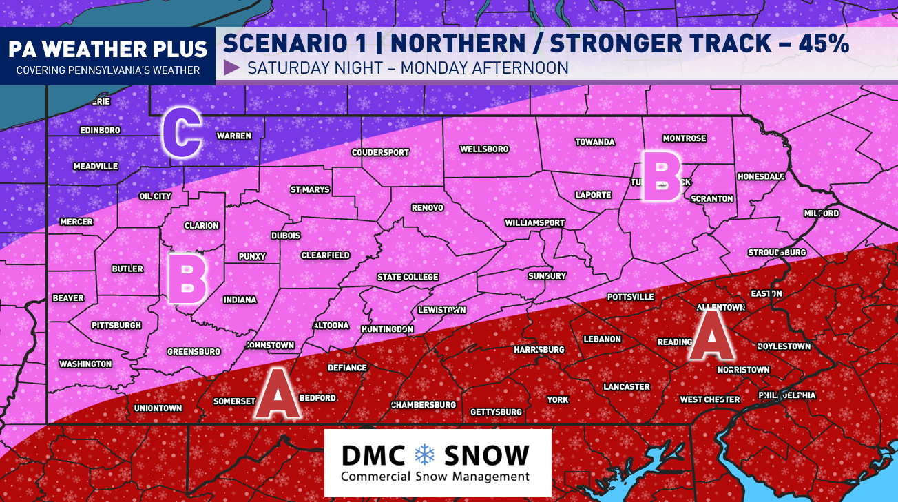
SCENARIO 1- MOST LIKELY (45%)
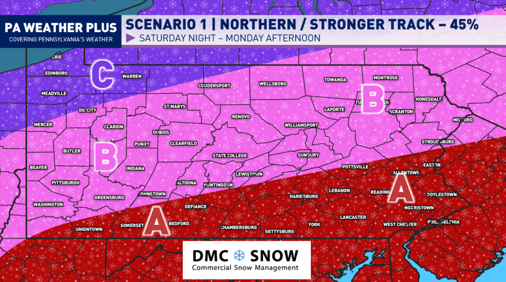
This is now the most likely scenario with the recent model guidance, ensembles, and pattern recognition. The most likely scenario will bring very significant to crippling impacts across the state, with the heaviest of the snow focused in southern Pennsylvania.
AREA A: Crippling snowfall amounts are likely with this scenario. With coastal low development, some areas may receive blizzard conditions with increasing wind gusts as a coastal low develops. A long-term duration snowfall event of 24+ hours. Power outages may occur with heavy snowfall and increasing wind gusts.
AREA B: Major snowfall amounts are likely with this scenario. Localized banding within the storm will allow for spots to receive crippling snowfall amounts. A long-term duration snowfall event of 24+ hours.
AREA C: Significant snowfall amounts are likely with this scenario. Localized banding within the storm will allow for spots to receive major snowfall amounts. A medium-to-long term duration snowfall event of 12+ hours.
SCENARIO 2- SOUTHERN SOLUTION (30%)
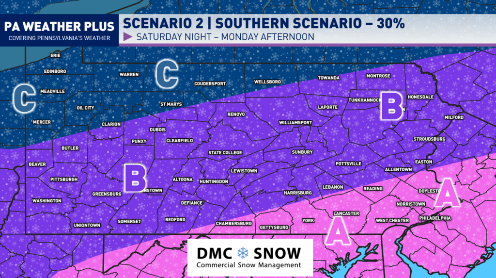
This solution will occur if we see a southerly trend with a strong Arctic high-pressure system. This will shift the worst of the snowfall amounts to the southern regions of Pennsylvania. Nevertheless, it would still bring significant impacts to the region.
AREA A: Major snowfall amounts are likely with this scenario. A long-term duration snowfall event of 24+ hours. Power outages may occur with heavy snowfall and increasing wind gusts.
AREA B: Significant snowfall amounts are likely with this scenario. Localized banding within the storm will allow for spots to receive major snowfall amounts. A long-term duration snowfall event of 12+ hours.
AREA C: Moderate snowfall amounts are likely with this scenario. A shorter-term duration event of 6 – 12 hours.
SCENARIO 3- NORTHERN SOLUTION (25%)
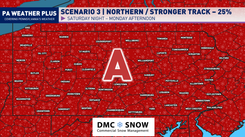
This scenario will occur with a much more northern and amplified storm track. This would rival some of the top storms you have experienced in your lifetime with widespread crippling snowfall amounts, higher wind gusts, and cold temperatures.
AREA A: Crippling snowfall amounts are likely with this scenario. With coastal low development, some areas may receive blizzard conditions with increasing wind gusts. A long-term duration snowfall event of 24+ hours. Power outages may occur with heavy snowfall and increasing wind gusts.
WHAT SHOULD YOU DO NOW?
![]() If you’re a snow-lover hoping for the “big one,” excitement is building as guidance continues to show high-end potential with this system.
If you’re a snow-lover hoping for the “big one,” excitement is building as guidance continues to show high-end potential with this system.
![]() For those who appreciate early heads-up messaging, stay tuned for continued updates. If you have travel plans from Saturday night through Monday, I strongly recommend considering a backup plan or rescheduling if possible.
For those who appreciate early heads-up messaging, stay tuned for continued updates. If you have travel plans from Saturday night through Monday, I strongly recommend considering a backup plan or rescheduling if possible.
![]() If you prefer to wait until the day before to follow the forecast, feel free to scroll on. While changes are still possible, we are increasingly honing in on a higher-end scenario at this time.
If you prefer to wait until the day before to follow the forecast, feel free to scroll on. While changes are still possible, we are increasingly honing in on a higher-end scenario at this time.
I will be on top of it the rest of the week- stay tuned for updates! I will have more updates on the Facebook page!
-Meteorologist Denys K.