The lake effect snow machine has not turned off yet for the winter season! As long as Lake Erie remains unfrozen, blasts of Arctic air will continue to produce lake effect snowstorms throughout the rest of the season. Back in September, I noted this upcoming winter to be particularly active for lake effect, and that is still holding true!
You are able to jump to the snowfall forecast below.
JUMP TO THE FOLLOWING:
METEOROLOGICAL PERSPECTIVE:
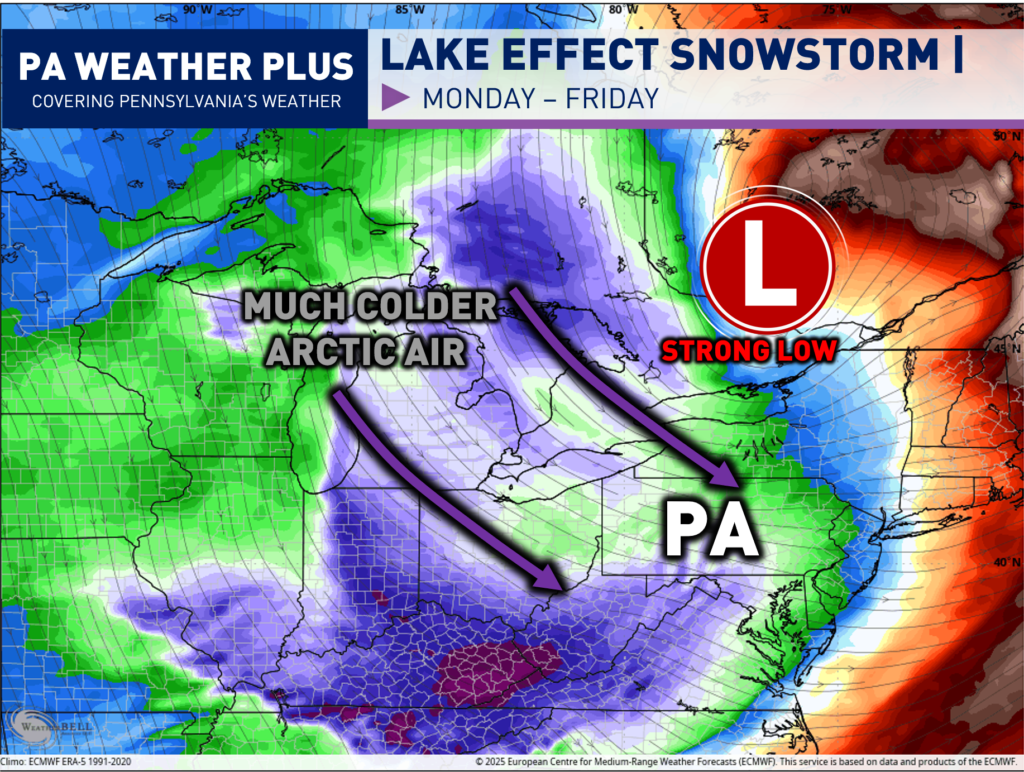
A strong low-pressure system will be moving off to our north and east later on Monday. Behind the low pressure system, *much* colder air will filter in out of the northwest. Temperatures will be as much as 25 to 35 degrees colder across western Pennsylvania, comparing Sunday evening to Monday evening. With the cold air with strong northwesterly flow, this sets up the perfect conditions for a long-term lake effect snowstorm. Multiple weaker systems will be moving in from the northwest throughout the week, which will help to kickstart the machine multiple times throughout the week!
SIMULATED RADAR GIF:
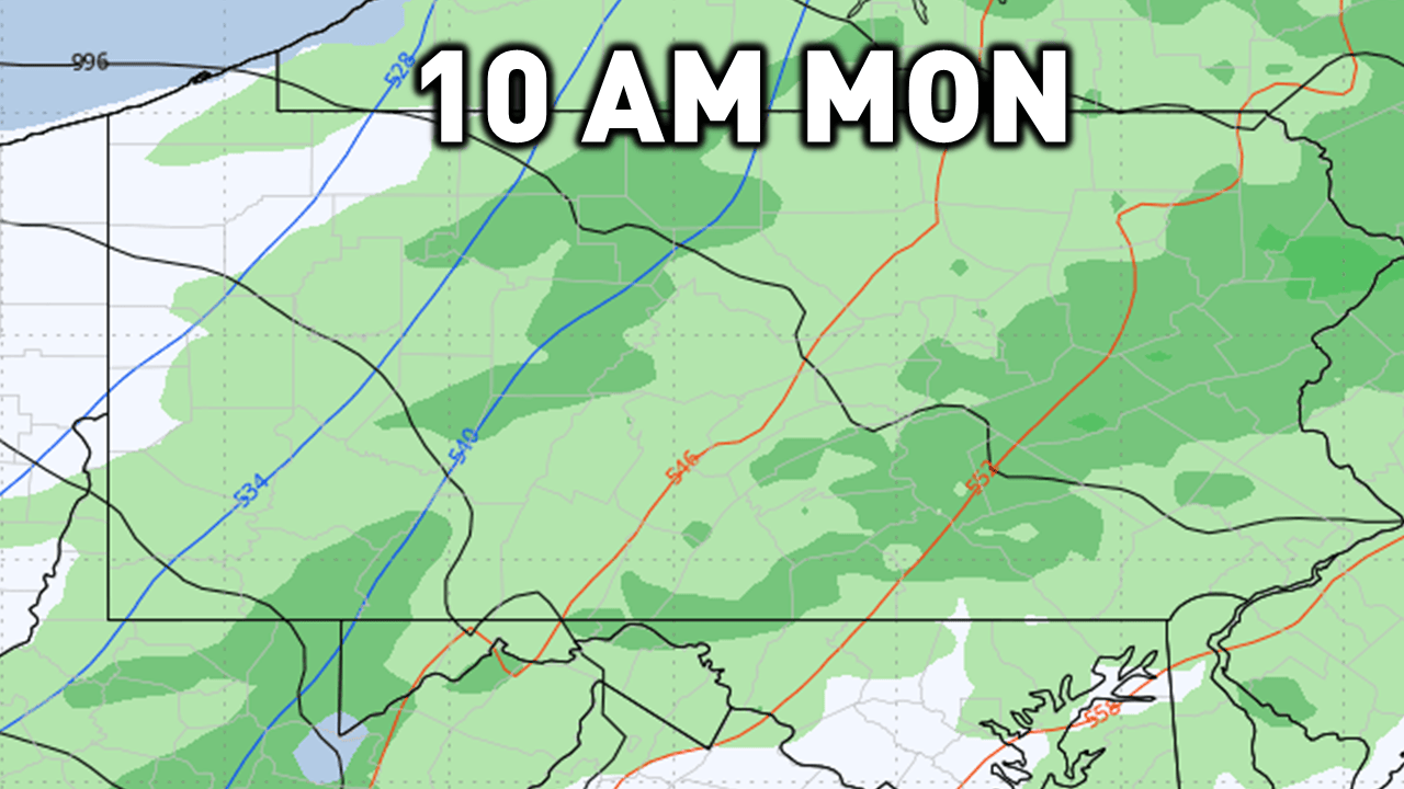
Here is a GIF simulating the future radar from Monday morning through Wednesday morning. Rain will change over to lake effect snow showers on Monday afternoon. The worst of the lake effect snowfall will occur Monday night into Tuesday morning. It will then lighten up Tuesday afternoon before another steadier round arrives Tuesday night into Wednesday morning / afternoon. Additional rounds of lake effect snow are expected Wednesday afternoon through Friday morning. This blog is specific through Wednesday morning.
I have a page on the website dedicated to giving you a more accurate timing forecast for your given location. Check it out here! Your Local Weather
WINTER WEATHER ALERTS:
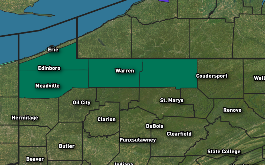
As of Sunday evening, a Lake Effect Snow Warning is in effect for Crawford, McKean, Southern Erie, and Warren counties, where heavy lake-effect snow is expected to create hazardous travel conditions and rapidly changing visibility. Check back on weather.gov for an updated list of National Weather Service alerts.
Whiteout conditions are possible and could make travel treacherous and potentially life-threatening. Blowing snow may significantly reduce visibility at times, and hazardous conditions could impact the Monday evening and Tuesday morning commutes. In addition, strong winds may lead to isolated tree damage and power disruptions.
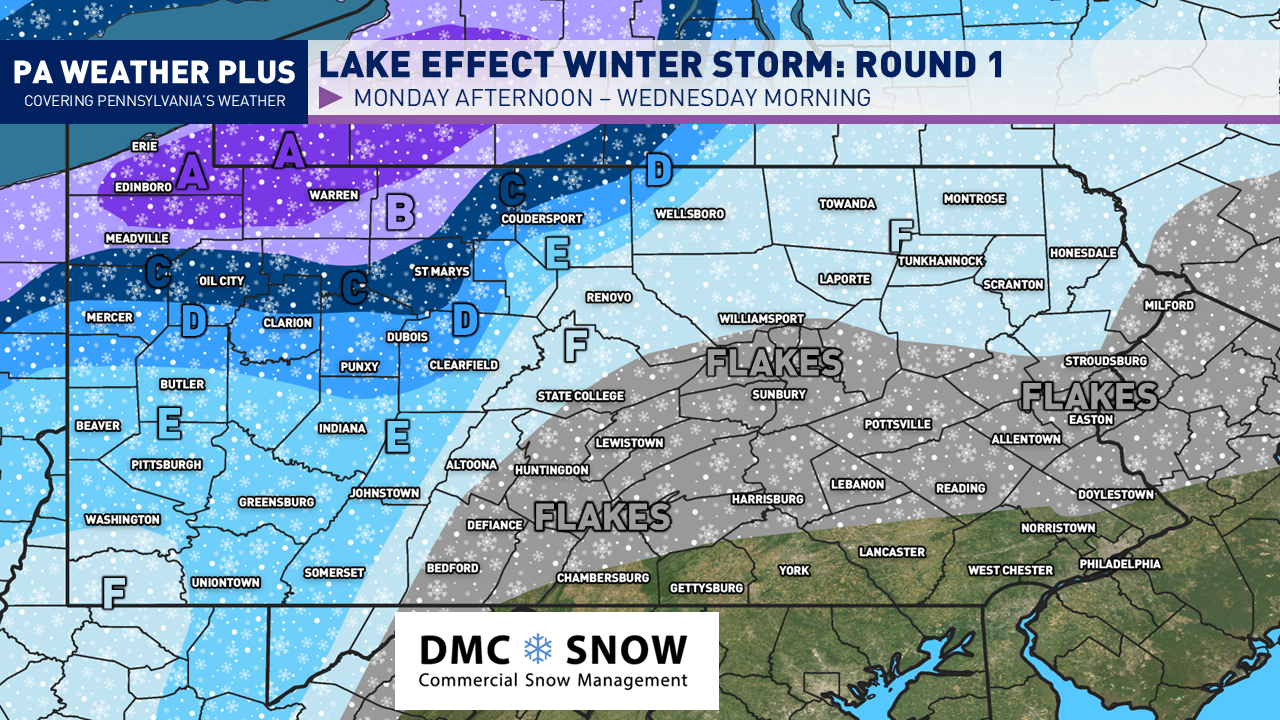
SNOWFALL FORECAST MONDAY – WEDNESDAY MORNING:

AREA A: 10 to 14 inches of snow expected with locally higher amounts. Expect treacherous travel conditions with snowfall rates exceeding 1″/hr in the heaviest snowfall bands. Travel may become impossible at times. Snow and reduced visibility will significantly impact travel on I-79 and I-90.
AREA B: 6 to 10 inches of snow expected with locally higher amounts. Expect treacherous travel conditions with snowfall rates exceeding 1″/hr in the heaviest snowfall bands. Travel may become impossible at times. Snow and reduced visibility will significantly impact travel on I-79.
AREA C: 4 to 6 inches of snow expected with locally higher amounts. Expect slow travel with brief moderate to heavy snowfall rates in localized banding. Travel may become hazardous at times. Snow and reduced visibility will significantly impact travel on I-79 and I-80.
AREA D: 2 to 4 inches of snow expected. Expect slow travel with brief moderate to heavy snowfall rates in localized banding. Travel may become hazardous at times.
AREA E: 1 to 2 inches of snow expected. Snow showers are expected to be generally light to moderate, but squalls may briefly reach heavy intensity. Expect slow travel with reduced visibility during snow squall activity.
AREA F: Coating to 1 inch of snow expected. Snow showers are expected to be generally light to moderate, but squalls may briefly reach heavy intensity. Expect slow travel with reduced visibility during snow squall activity.
Be prepared for a long week of continued lake effect snow activity. Additional snow accumulations will be expected Wednesday morning through Friday morning as a few more weak disturbances move through, kicking “on” the lake effect snow machine.
-Meteorologist Denys K.
Blog Updated: 12/28/2025 at 6:16 PM