Estimated reading time: 5 minutes
This Saturday evening we are sitting in the ‘warm sector’ of the low pressure system. This means temperatures have warmed up into the 50s and 60s for many this afternoon with mostly cloudy skies and a few rain showers. This all changes tonight as a strong cold front sweeps through the state, ushering another blast of winter air. As the snow begins, when you combine a winter airmass with warm Great Lake waters, that is the perfect recipe for lake effect snowfall. We are in for another round, beginning late Sunday afternoon and lasting through Monday morning. Some areas will receive decent snowfall accumulations.
IMPRESSIVE SNOW BAND
This will be quite the lake effect snow band! The beginning of the band will start up on the north side of Lake Superior, which will then stretch through Lake Huron and eventually through Lake Erie. With multiple lake connections, this will be a very dynamic snow band and possible produce heavy snowfall accumulations across portions of Pennsylvania. Snow showers from this band could stretch into portions of south-central and southeastern Pennsylvania!

FUTURE SIMULATED RADAR
Once the cold front passes through Sunday morning, the lake effect machine will turn on by Sunday afternoon. Expect snow bands and squalls to begin to develop throughout the state. Some impacts may begin to occur, especially across northwestern Pennsylvania where temperatures will be the coldest.

By the evening hours, the lake effect bands will continue across northwestern and portions of central Pennsylvania. Notice how there is very little movement in the band across northwestern Pennsylvania. It is possible this band of snow produces moderate to heavy snowfall rates, with travel conditions rapidly worsening toward and after sunset.

By the overnight hours, one lake effect band will steal the show, moving from northwestern Pennsylvania down into south-central Pennsylvania past Harrisburg and Lancaster. This will be one large band of snow that will extend from Lake Superior, extending 700+ miles! The reason this band of snow has the potential to be significant is due to the fact it will be connecting across Lake Huron and Lake Erie, adding to its fuel and moisture source. Heavy rates across portions of northwestern Pennsylvania may exceed 1″/hr at time.

By Monday morning, there is still very little movement in the band. Those that sit in the band, especially north of I-80, could receive significant snowfall accumulations. We have pretty great dynamics at play with a multiple lake connection. This corridor of significant snowfall will be small, with some areas going from little to significant snowfall in as little as 5 – 15 miles. The Monday morning commute could be rough for those areas that sit in the band through the overnight.

By Monday morning, the lake effect band will still sit across portions of northwestern Pennsylvania. While the majority of the impacts will begin to taper, some snow will likely linger into Monday early afternoon. By the mid-to-late afternoon hours, we should see all of the snow bands taper away wit

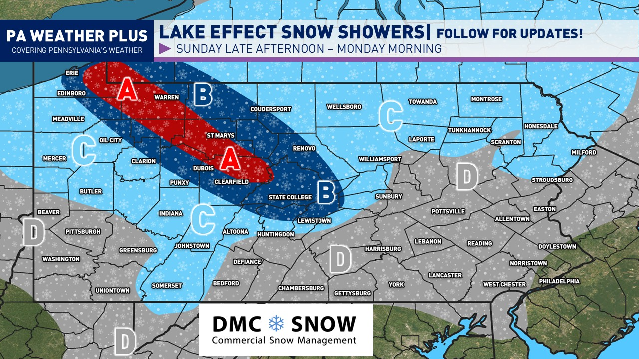
SNOWFALL IMPACTS MAP

AREA A: Most likely region for the intense lake effect snow band to stall from Sunday late afternoon through Monday morning. Snowfall rates may exceed 1″/hr at times. The potential snowfall range is large, which is dependent on where the snow band sets up and lingers. Expect 3 to 9 inches of snowfall. Higher amounts of 9 to 12 inches cannot be ruled out in isolated spots, especially in locally higher terrain. Travel will likely be treacherous Sunday night through Monday morning.
AREA B: This region will likely be outside of the intense lake effect snow band, although the band may pivot through this area at times, adding to snowfall accumulations. Expect 1 to 3 inches of snowfall. Isolated higher amounts are possible, especially if the band shifts outside of ‘Area A’ for extended periods of time. Travel conditions will likely be slick Sunday night through Monday morning.
AREA C: Generic lake effect snow showers and outside bands outside of the ‘main band’ are possible. Up to an inch of snowfall is possible. Some roadways may become slick Sunday night through Monday morning.
AREA D: A few lake effect snow showers and snow pellets possible Sunday afternoon through Monday morning. Snowfall accumulations are generally not expected, although a quick dusting is possible once temperatures cool off late Sunday night in any heavier snow shower. Issues are generally not expected outside isolated spots.
This is a very dynamic setup with some changes possible, depending on the placement of the lake effect snow band. Stay tuned for updates!
-Meteorologist Denys K.