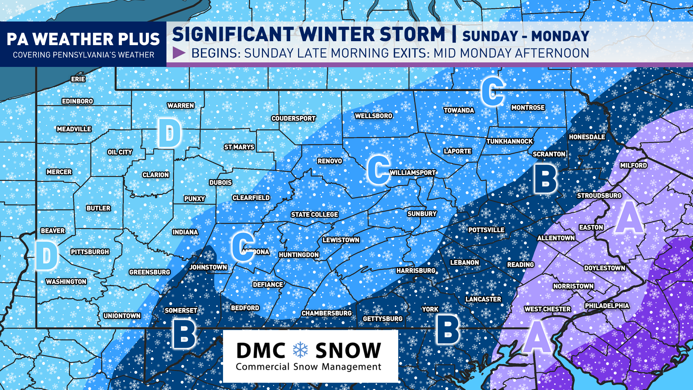
We have another significant winter storm on our doorstep, which will bring impacts to much of the state beginning Sunday afternoon and lingering through the first half of Monday. Back on Wednesday, I released potential scenarios with this setup. At the end, it appears Scenario #3 will be the closest to verification, as we’ve seen a significant uptrend toward a strong coastal low-pressure system, wrapping moderate to heavy snowfall into much of Pennsylvania. Up to a foot of snow will be possible across eastern Pennsylvania, with less snowfall the farther west you are located. No matter how much you get, everyone will see some sort of impact
If you are here for the snowfall map only, press “FIRST CALL SNOWFALL AMOUNTS” to jump to the bottom of the article!
CLICK TO JUMP TO THE FOLLOWING:
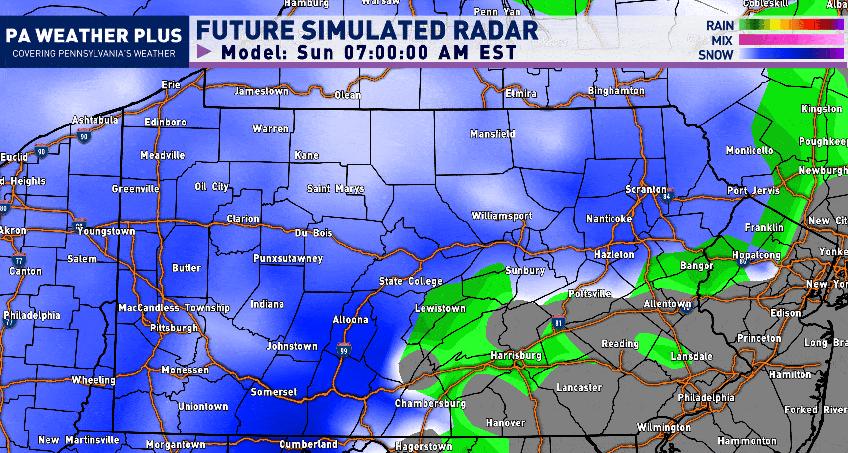
FUTURE RADAR SIMULATION:
Snowfall Begins: Sunday Morning through Sunday Early Afternoon. Snowfall rates may be light enough not to cause problems. Temperatures to begin will be between 33 – 37 degrees.
Worst Period of Snow: Sunday Late Afternoon through Monday Early Morning. Expect steady snowfall rates with falling temperatures and increasing wind gusts. It is highly recommended you stay off of roadways during this time period, especially across central and eastern Pennsylvania. This will be the worst period of this significant winter storm.
Snow Begins to Taper: Monday Late Morning through Monday Late Afternoon: Snow will begin to taper off west-to-east throughout the state. Ignore the rain at the end; this is an error in the simulation software (showing up as “dry air” as rain). Temperatures will begin to warm up as well, helping with snow clean-up efforts. Expect roads to remain snow-covered throughout the day as cleanup may take a while.
I have a page on the website dedicated to giving you a more accurate timing forecast for your given location (available 48 hours out in advance). Check it out here! Your Local Weather
WINTER WEATHER TRAVEL IMPACTS:
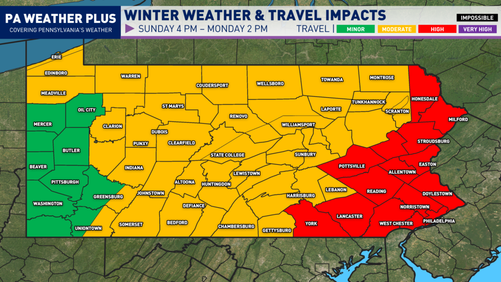
HIGH: Snow and/or ice will impact most roadways, including many highways and interstates. Hazardous driving conditions will increase the risk of accidents. Avoid non-essential travel.
MODERATE: Snow and/or ice will affect scattered roadways and some highways. While conditions remain less severe, accidents can still occur. Use caution, reduce speeds, and allow extra travel time.
MINOR: Isolated roadways may become snow- or ice-covered. Impacts remain limited, but slick spots can develop. Stay alert, slow down, and drive with caution.
FIRST CALL SNOWFALL FORECAST:
AREA A: Significant winter storm conditions. Heavy snowfall expected, with snowfall rates up to 1″ per hour. 8 to 12 inches of snow. Wind gusts of 35 to 45 MPH may lead to blowing and drifting, causing significant snow drifts. Isolated power outages may result. Expect school/business closures on Monday and possibly into Tuesday.
AREA B: Moderate to heavy snowfall expected, with snowfall rates up to 0.5″ per hour. 5 to 8 inches of snow. Wind gusts of 25 to 35 MPH may lead to some blowing and drifting. A power outage or two may result, but unlikely. Expect school/business closures on Monday.
AREA C: Moderate snowfall expected. 3 to 5 inches of snow. Wind gusts of 25 to 30 MPH may lead to some minor blowing and drifting. Expect school/business delays on Monday.
AREA D: Light snowfall expected. 1 to 3 inches of snow. Some school/business delays are possible on Monday morning.
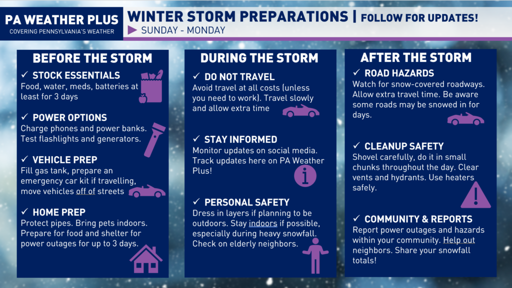
WHAT SHOULD I DO TO PREPARE?
Here are some winter storm preparation tips: Make sure you stock up on essentials like food, water, medications, and batteries, and charge your phones and power banks ahead of time. Fill your gas tank, prepare your vehicle, and avoid unnecessary travel during the storm if possible. If you are prone to power outages (mostly applies to Area A), make sure you have enough food and water to last at least 3 days! Stay informed by monitoring the latest forecasts and updates, use caution when shoveling snow and traveling on icy roads, and check on neighbors. Report any power outages or hazards in your community and continue to follow PA Weather Plus for updates.
Thank you for taking the time to read through the blog post. Updates will be posted on my Facebook, Instagram, and X social media pages. A final forecast/blog post will be released by 6 PM Saturday afternoon. Stay tuned for updates and feel free to reach out with any questions/concerns. I will try to answer as many questions as I am able.
CLICK HERE TO FOLLOW ON FACEBOOK!
-Denys