

We have a major winter storm on our doorstep with the first flakes set to fall in as little as 12 hours. What appeared to be a miss to the east, we have seen a significant shift westward and amplified for the last 48 hours and here is where we land. A Major East Coast winter storm is expected, with the worst of the impacts in Pennsylvania holding to far eastern regions. Nevertheless, *EVERYONE* will see some sort of snowfall impacts Sunday morning through Monday evening.
If you are here for the snowfall map only, press “MAJOR SNOWSTORM SNOWFALL FORECAST” to jump to the bottom of the article!
CLICK TO JUMP TO THE FOLLOWING:
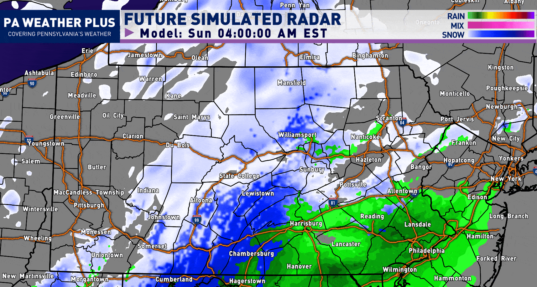
FUTURE RADAR SIMULATION:
Snowfall Begins: Sunday Morning through Sunday Early Afternoon. Snowfall rates may be light enough not to cause problems. Temperatures to begin will be between 33 – 37 degrees.
Worst Period of Snow: Sunday Late Afternoon through Monday Early Morning. Expect steady snowfall rates with falling temperatures and increasing wind gusts. It is highly recommended you stay off of roadways during this time period, especially across central and eastern Pennsylvania. This will be the worst period of this significant winter storm. Snowfall rates of 1 to 3 inches an hour will be expected across much of eastern Pennsylvania.
Snow Begins to Taper: Monday Late Morning through Monday Late Afternoon: Snow will begin to taper off west-to-east throughout the state. Temperatures will begin to warm up as well, helping with snow clean-up efforts. Expect roads to remain snow-covered throughout the day as cleanup may take a while, especially in areas that see 12 inches or more of snow with very strong winds.
Feel free to let the GIF play out. The timing is in the banner:
I have a page on the website dedicated to giving you a more accurate timing forecast for your given location (available 48 hours out in advance). Check it out here! Your Local Weather
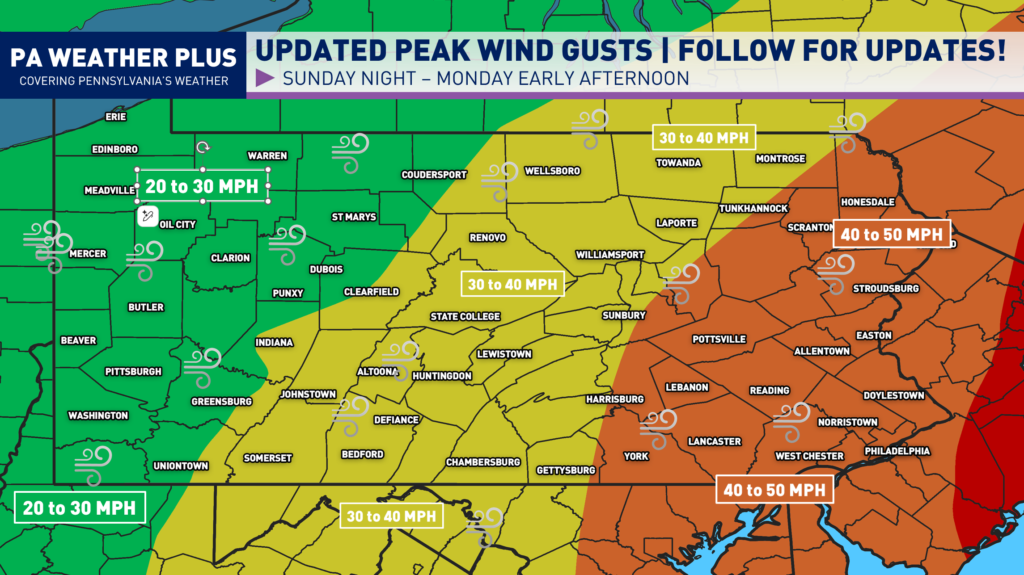
PEAK WIND GUSTS:
Due to the rapid strengthening of the low pressure system offshore, we will see stronger wind gusts across much of the state, focused across eastern Pennsylvania. Gusty winds will lead to isolated power outages in the 30 – 40 MPH zone, and scattered to perhaps numerous in the 40 – 50 MPH zone. The snow will initially be wet and heavy, which will stick to trees and powerlines. Once the winds begin to pick up late Sunday night, we may see powerlines and trees begin to come down, mostly across eastern Pennsylvania. If you are prone to losing power, please make sure you are prepared and follow safety tips down below.
WINTER WEATHER TRAVEL IMPACTS:
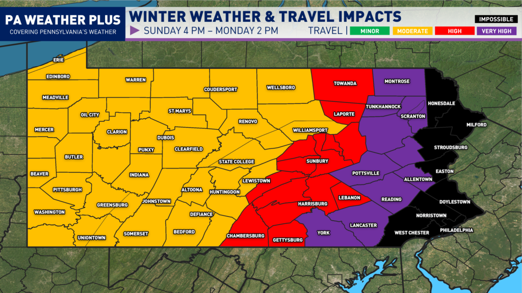
IMPOSSIBLE: Very heavy snowfall will nearly make all roadways impassable, including major highways and interstates. Travel will be impossible for most vehicles, with a high likelihood of stranded motorists, jackknifed trucks, and emergency response delays. Do not travel under any circumstances unless it is life-threatening. Watch for falling trees and power lines on roads due to strong winds and heavy snowfall.
VERY HIGH: Widespread snow and/or ice will cover nearly all roadways, including major highways and interstates. Severe winter storm conditions will create extremely dangerous travel. Vehicles may become stranded, especially during the heaviest snow and/or ice. Travel will be impossible at times. Do not travel unless absolutely necessary.
HIGH: Snow and/or ice will impact most roadways, including many highways and interstates. Hazardous driving conditions will increase the risk of accidents. Avoid non-essential travel.
MODERATE: Snow and/or ice will affect scattered roadways and some highways. While conditions remain less severe, accidents can still occur. Use caution, reduce speeds, and allow extra travel time.
MAJOR SNOWSTORM SNOWFALL FORECAST:
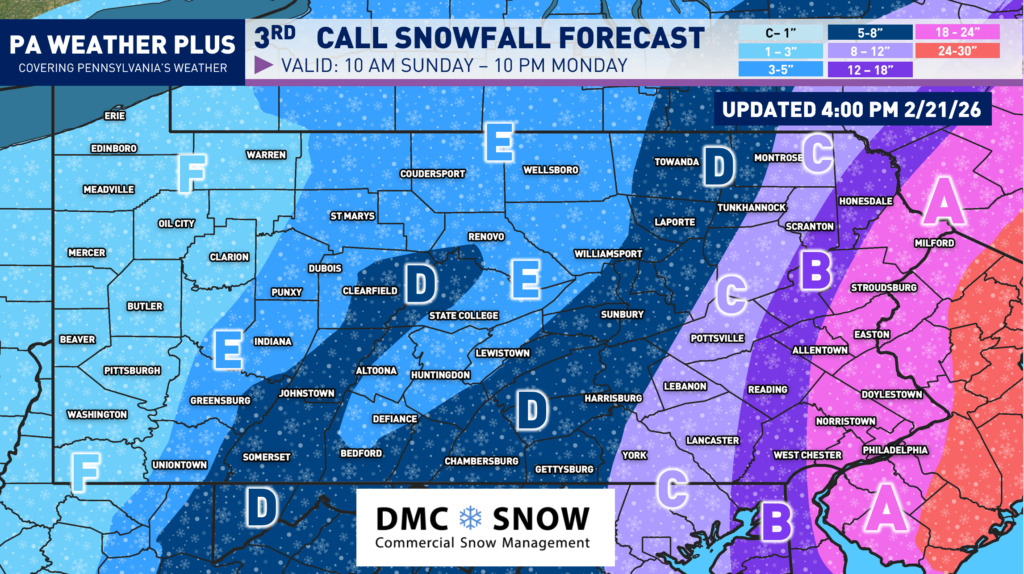
MAJOR SNOWSTORM:
AREA A: Major winter storm conditions. Very heavy snowfall expected, with snowfall rates up to 1-3″ per hour. 18 to 24 inches of snow, isolated regions may see up to 28 inches. Wind gusts of 40 to 50 MPH may lead to blowing and drifting, causing significant snow drifts. Scattered to numerous power outages may result. Expect school/business closures on Monday and possibly into Tuesday.
AREA B: Major winter storm conditions. Heavy snowfall expected, with snowfall rates up to 1-3″ per hour. 12 to 18 inches of snow. Wind gusts of 40 to 45 MPH may lead to blowing and drifting, causing significant snow drifts. Scattered power outages may result. Expect school/business closures on Monday and possibly into Tuesday.
SIGNIFICANT SNOWSTORM:
AREA C: Significant winter storm conditions. Heavy snowfall expected, with snowfall rates up to 1″ per hour. 8 to 12 inches of snow. Wind gusts of 35 to 45 MPH may lead to blowing and drifting. Isolated power outages may result. Expect school/business closures on Monday and possibly into Tuesday.
AREA D: Moderate to heavy snowfall expected, with snowfall rates up to 0.5″ per hour. 5 to 8 inches of snow. Wind gusts of 25 to 35 MPH may lead to some blowing and drifting. A power outage or two may result, but unlikely. Expect school/business closures on Monday.
LIGHT / MODERATE SNOWSTORM:
AREA E: Moderate snowfall expected. 3 to 5 inches of snow. Wind gusts of 25 to 30 MPH may lead to some minor blowing and drifting. Expect school/business delays on Monday.
AREA F: Light snowfall expected. 1 to 3 inches of snow. Some school/business delays are possible on Monday morning.
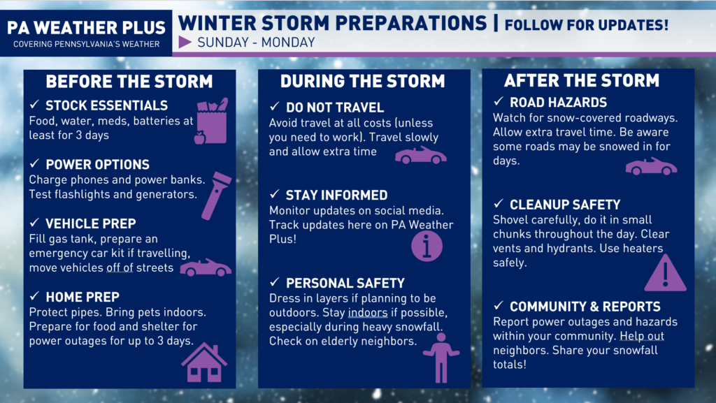
HOW DO I PREPARE FOR A WINTER STORM?
Here are some winter storm preparation tips: Make sure you stock up on essentials like food, water, medications, and batteries, and charge your phones and power banks ahead of time. Fill your gas tank, prepare your vehicle, and avoid unnecessary travel during the storm if possible. If you are prone to power outages (mostly applies to Area A – D), make sure you have enough food and water to last at least 3 days! Stay informed by monitoring the latest forecasts and updates, use caution when shoveling snow and traveling on icy roads, and check on neighbors. Report any power outages or hazards in your community and continue to follow PA Weather Plus for updates.
Thank you for taking the time to read through the blog post. Updates will be posted on my Facebook, Instagram, and X social media pages. This will be the final blog post for this storm. If necessary, a snowfall update may be released 7 AM on Sunday. Stay tuned for updates, and feel free to reach out with any questions/concerns. I will try to answer as many questions as I am able.
CLICK HERE TO FOLLOW ON FACEBOOK!
-Denys
