Estimated reading time: 6 minutes
If you have felt that northwestern Pennsylvania has been stealing the snow as of late, you’re not wrong! The pattern has been favorable for lake effect winter storms, while the rest of the state receives the short end of the stick with remnant snow showers and squalls. First the first time this season, a more widespread snow system is forecasted to impact the state. As we prepare for this upcoming snow event, there has been a lot of hype regarding this storm system, so let’s dig into all of the details and the first call snowfall amounts!
LITTLE BIT OF METEOROLOGY:
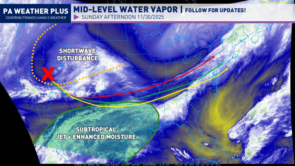
We can learn a lot by looking at our current mid-level water vapor satellite imagery across the United States. Our shortwave associated with the incoming snow system is beginning to move into the Rockies, and is expected to eject eastward over the next 24 hours. I have outlined 3 potential scenarios that are still to come. The red scenario is a more amplified track, where it would bring a warmer system and move the mixing line more northward. The green arrow, which is the scenario I am favoring, will bring snow to much of Pennsylvania with mixing expected across south-central and southeastern Pennsylvania. A more southern / weaker solution, or the yellow arrow, is becoming less favorable, although if verified, this would bring the heaviest snow farther south and less mixing would occur in southeastern Pennsylvania.
Additionally, we have a stronger subtropical jet that will help bring enhanced moisture into the system as the shortwave dives southward, tapping into this moisture source. This will help pull in extra moisture, giving us a greater amount of precipitation. This is the reason we could see areas of significant snowfall amounts despite it being a fast-tracked system.
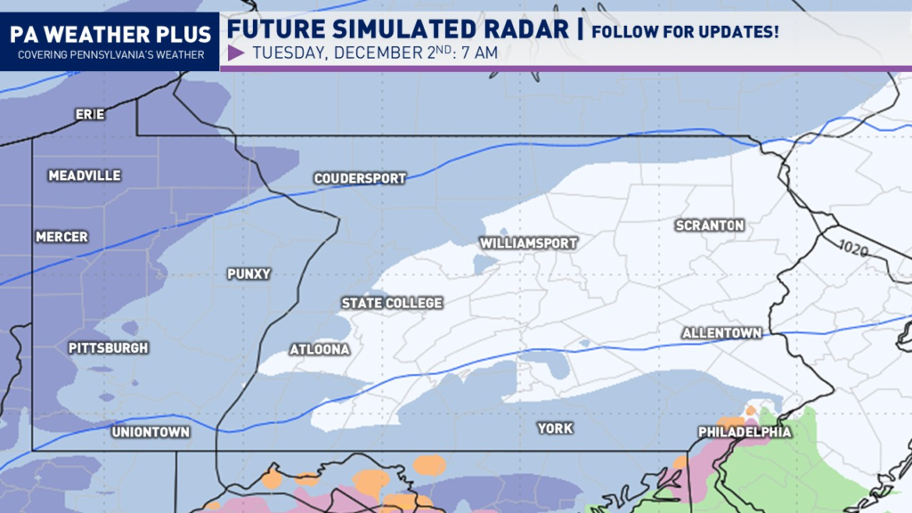
SIMULATED FUTURE RADAR:
In general, snow should only last between 8 – 14 hours at any given point. This system is in fast, and it is out fast! The fast track of the system will limit the higher-end snowfall amounts as we have no atmospheric blocking. If we had atmospheric blocking, this would have been a more significant winter storm, but we got lucky (or unlucky) this time around.
Snow will begin to overspread portions of the state by early Tuesday morning, with the steadiest snow occurring across western Pennsylvania. Some wintry mix will be possible in Philadelphia.
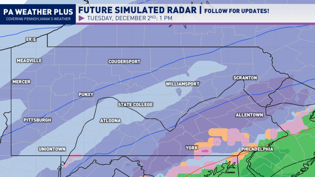
By the late morning and through the early afternoon is when the bulk of the storm will occur. The steadiest snow will occur across much of south-central through northeastern Pennsylvania. Snowfall rates of 0.50 – 0.75″ per hour will lead to reduced visibility and snow-covered roadways.
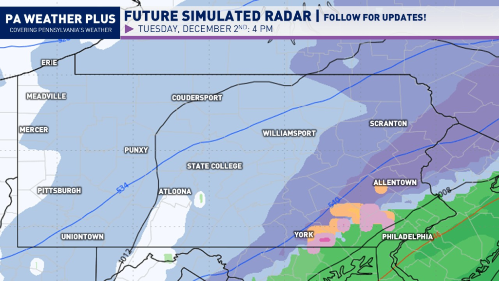
By the late afternoon and toward sunset, snow will continue to fall across much of eastern Pennsylvania, with snow showers beginning to wrap up across western and central Pennsylvania. There will still be snow-covered roadways due to decreasing sunlight and falling temperatures.
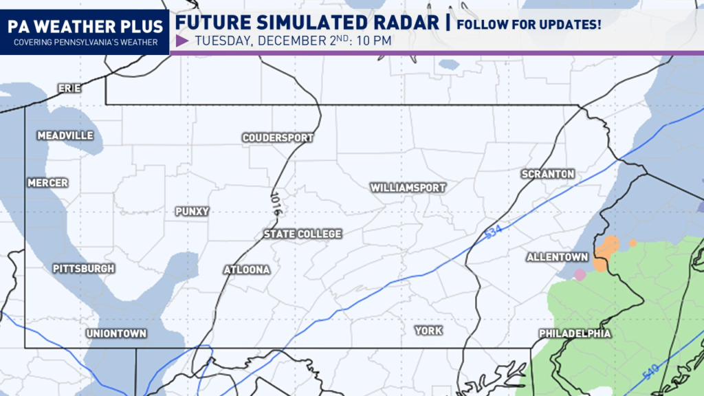
By the evening hours, much of the precipitation will have now exited with a few lake effect snow showers possible across far western Pennsylvania and perhaps some lingering minor action in far eastern PA.
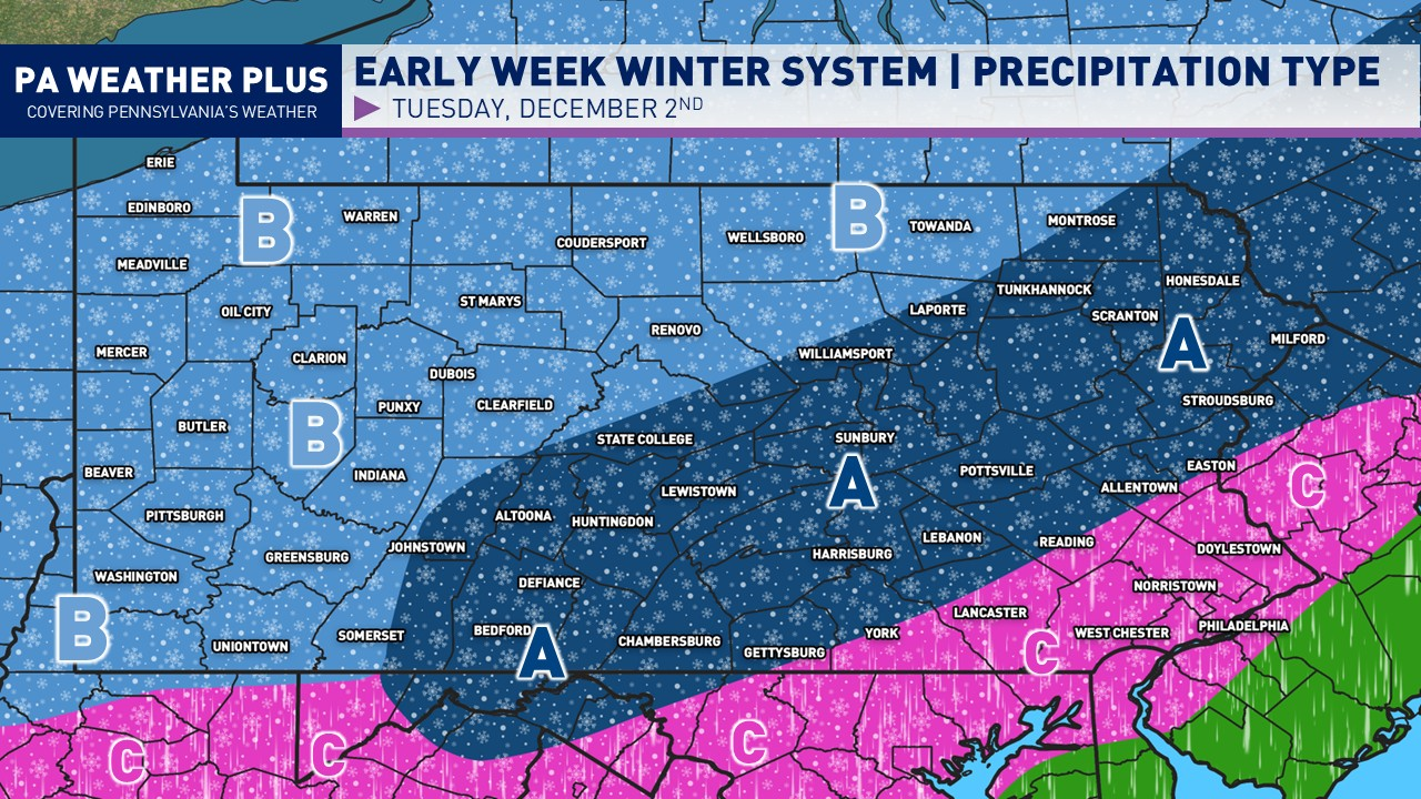
PRECIPITATION TYPE & INTENSITY:
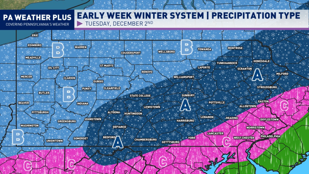
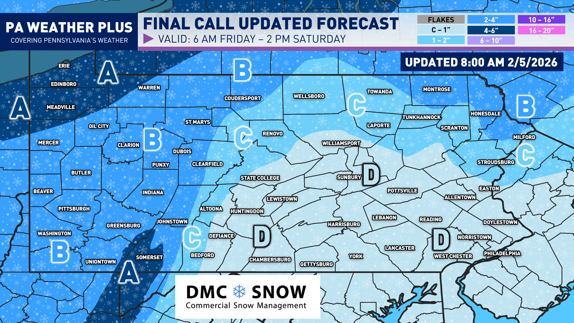
AREA A: This region will likely see the steadiest, and at times moderate to heavy snowfall, late Tuesday morning and through the afternoon. Mixing is not expected, although a few sleet pellets may mix in for those closer to Area C.
AREA B: This region will likely see all snow and it may be steady at times, but overall will be light in intensity.
AREA C: This region will begin as a thump of snow and possibly sleet, before changing over to rain by late Tuesday morning and into the early afternoon hours. A brief period of freezing rain / drizzle also cannot be ruled out before surface temperatures warm above freezing. The closer you are to Area A, the longer you will take to changeover.
FIRST CALL SNOWFALL FORECAST:
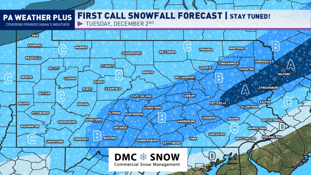
AREA A: Significant amounts of 5 to 8 inches of snow expected. Expect potentially moderate to heavy snowfall rates. Snow-covered roads are likely with business and school disruptions expected. I would highly recommend remaining off of roadways. Some towns/cities in this zone: Stroudsburg and Milford.
AREA B: Moderate snowfall amounts of 3 to 5 inches of snow expected. Expect potentially moderate to heavy snowfall rates, although shorter in duration compared to Area A. Snow-covered roads are likely with business and school disruptions expected. I would highly recommend remaining off of roadways. Some towns/cities in this zone: Scranton, State College, Harrisburg, Allentown, and Easton.
AREA C: Light snowfall amounts of 1 to 3 inches of snow expected. Overall, light snowfall rates are expected, but may become briefly moderate at times during the peak event. Snow-covered roads are possible with some business and school disruptions, primarily in the highest elevations. Interstates and well-treated roadways should be okay, but if you are planning to travel, please take it slow and use caution! Some towns/cities in this zone: Erie, Pittsburgh, Butler, Uniontown, and Lancaster.
AREA D: Very light snowfall amounts of less than an inch of snow expected. Minimal travel disruptions may occur during the morning commute. Some towns/cities in this zone: Philadelphia.
With it being the first widespread snow event for Pennsylvania, it is highly recommended that you stay tuned to updates! Remember to disregard the hype you see online, as pages will post the snowiest model runs every 6 hours to try to scare you. I try to bring all of the facts, and I am leaning toward a weaker solution. While weak, this will still bring travel impacts with snow-covered roadways. Stay tuned for updates!
-Meteorologist Denys K.