Estimated reading time: 6 minutes
As advertised for the last few days, the first accumulating snowfall event of the season is on our doorstep here in Pennsylvania! It is not often we see our first widespread light snowfall event of the season this early, but an anomalously cold air mass sweeping through the eastern United States will bring this potential. In fact, snow showers may be observed as far south as the northern elevations of Alabama and Georgia! It will also be cold, with wind chill values in the teens by Tuesday morning. Read below!
JUMP TO THE FOLLOWING:
FUTURE RADAR TIMING
Disclaimer: Keep in mind, these are simulated radar projections. They use high-res modeling. They may not be exactly 1:1 to what occurs from through Tuesday, especially with the mesoscale factor of lake effect snowfall. NOTE: For a more definitive timing for your location, check out the Your Local Weather page!
As our cold front sweeps eastward tonight, snow showers will be possible across western Pennsylvania. With warm ground temperatures, if any snow begins to stick across western Pennsylvania it will be defined mostly to elevated and grassy surfaces.

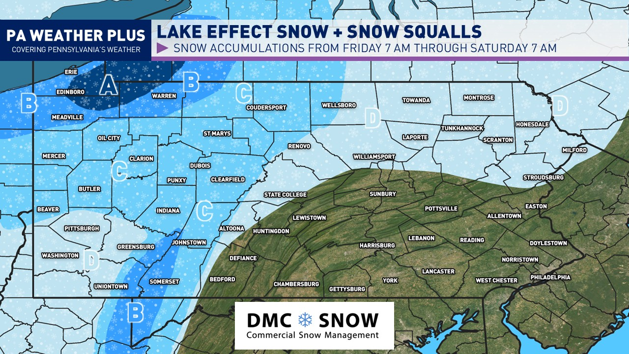
Throughout much of Monday morning and afternoon, expect a break in activity with a few snow showers / flurries. Snow showers will begin to ramp up as we see another disturbance move through, activating the lake effect snowstorm. Snow bands will begin to develop across western and northwestern Pennsylvania later Monday afternoon and lafter sunset.

Heavy lake effect bands will continue into late Monday evening and early overnight. Some of these lake effect bands closer to Lake Erie may produce snowfall rates upwards of 1″/hr. With surface temperatures in the 20s by now, accumulations will occur on roadways. Travel may become slick in spots.

The Tuesday morning commute will likely be the treacherous across northwestern Pennsylvania. Heavy lake effect snow bands will move through much of northwest PA. Some of these lake effect bands closer to Lake Erie may produce snowfall rates upwards of 1-1.5″/hr. During lake effect snow, the weather can vary from bands of locally heavy snow to dry weather just a few miles away. Visibilities can also vary greatly. Be prepared for rapid changes in weather, visibility, and road conditions.

Lake effect snow showers and snow squalls will continue into late Tuesday morning across much of western Pennsylvania. With cold temperatures, additional snowfall accumulations will continue, and even on some roadways. It will be a good idea to remain cautious, especially if you are planning to travel into northwestern Pennsylvania or in the higher elevations!

CURRENT WINTER WEATHER ALERTS
As of 6:00 PM 11/9/2025. Check weather.gov for an updated warning map!

Lake Effect Snow Warning: Erie, Crawford, Venango, Mercer, Westmoreland, Fayette, Indiana, and Cambria Counties.
Winter Weather Advisory: Warren and Erie Counties
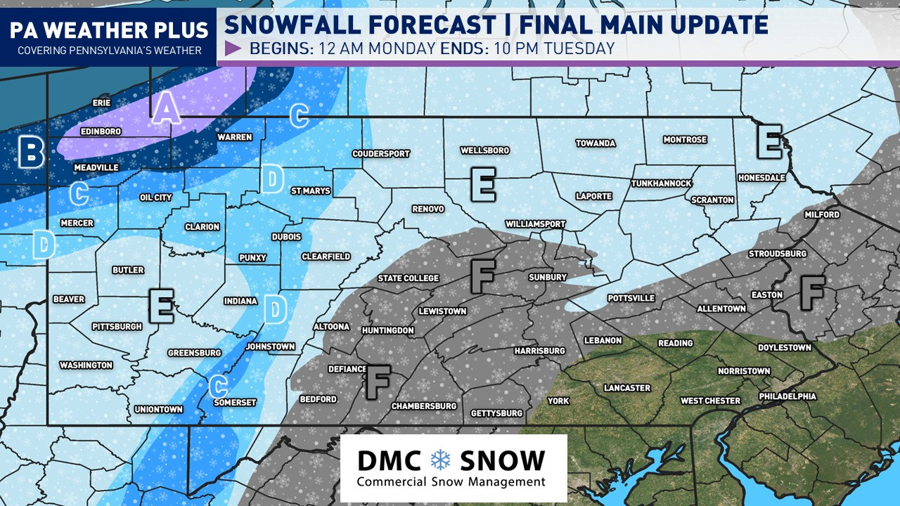
FINAL CALL PENNSYLVANIA SNOW FORECAST

These are total snowfall accumulations through 10 PM Tuesday, and it will fall in multiple rounds. The complete total may not reflect the total measured at 10 PM on Tuesday given melting and compaction. Lake effect areas may see locally more and/or less snowfall, which will be dependent on when and where the heaviest lake effect bands setup. The heaviest lake effect snow bands may produce snowfall rates upwards of 1-1.5″ per hour.
DEFINED IMPACTS BY LETTER:
AREA A – Total snowfall accumulations of 8 to 12 inches. Treacherous travel conditions are expected late Monday evening through Tuesday morning, when the heaviest snow bands will occur. Remain cautious during other time periods. Includes Edinboro.
AREA B – Total snowfall accumulations of 5 to 8 inches. Treacherous travel conditions are expected late Monday evening through Tuesday morning, when the heaviest snow bands will occur. Remain cautious during other time periods. Includes Erie and Meadville.
AREA C – Total snowfall accumulations of 3 to 5 inches. Slick travel conditions are expected late Monday evening through Tuesday morning, when the heaviest snow bands will occur. Remain cautious during other time periods. Includes Warren.
AREA D – Total snowfall accumulations of 1 to 3 inches. Areas of slick travel conditions are expected late Monday evening through Tuesday morning, when the heaviest snow bands will occur and in elevations greater than 1800ft. Remain cautious during other time periods. Includes Clarion, DuBois, Johnstown, Somerset, St Mary’s.
AREA E – Total snowfall accumulations of up to 1 inch or less. Slick travel is generally not expected, although heavier snow showers may produce a few slick roadways Monday night into Tuesday morning. Includes Pittsburgh, Butler, Washington, Scranton, Wellsboro.
AREA F – Snowfall accumulations generally not expected, with the first flakes of the season probable. If an unexpected heavier snow shower moves into this region Monday night and/or Tuesday morning, a quick 0.1″ or so may be possible on grassy surfaces.
As always, it is good to remain weather-aware and plan your travels safely! The first snow of the season is rated the most dangerous for drivers as it may come as a surprise and many local areas are still becoming prepared for the winter season. Take it slow and easy. If conditions are treacherous, especially across northwestern Pennsylvania, it will be good to stay home until the snow eases.
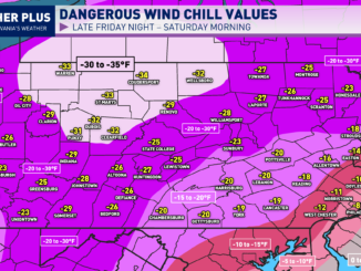
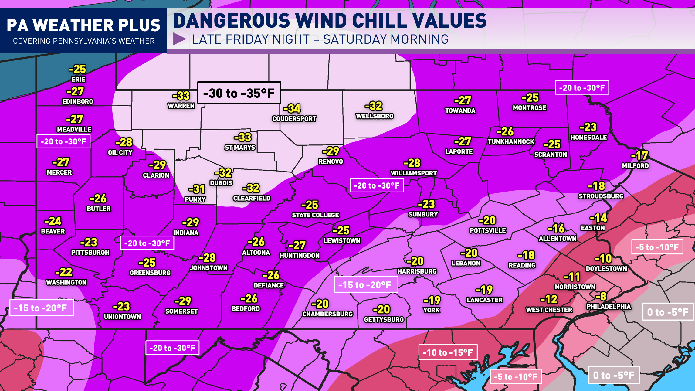
FRIGID TUESDAY MORNING WIND CHILLS
It will be a good idea to bundle up Tuesday morning, with or without snow! With temperatures dropping into the 20s for many locations, the gusty winds will make it feel as much as 10 to 25 degrees colder than the air temperature. Widespread wind chill values will be between 10 to 20 degrees across the state with single-digit wind chills possible in the Laurel Highlands above 2000 feet. A few places in West Virginia could see sub-zero wind chill values. Grab your winter coats and hats/gloves out of your closet today!

Share below to spread this weather update to your family, friends, etc, to keep them weather aware! I will have more updates regarding this event Monday morning and evening with additional real-time updates Tuesday morning.
-Meteorologist Denys Khrulov