Estimated reading time: 5 minutes
The first snowfall of the season is on the way! After months of showers and thunderstorms, the first coating of snow is always a joy! With the Christmas season upon us, the best time of the year to get snow is coming up! By late February and March, the snow will become an eyesore and we will all be ready for the summer warm-up. But for now, let’s take the time to enjoy this upcoming first event of the season!
JUMP TO THE FOLLOWING
ATMOSPHERIC SETUP
Why are meteorologists like me and others confident in the first snow of the season several days in advance? We can blame the East Coast trough that will move through late this weekend and into early next week. This has been well-predicted for several days now, and the signal is growing stronger. Taking a look, the 500 MB height, which varies (higher 500 MB height = warmer pattern, lower 500 MB height = colder pattern) day-to-day, will be as much as 400 – 500 meters below the normal for early November. When we have a signal this strong, we are looking at a rather cold shot of air for this time of year.

In fact, it will be very impressive. The *ENTIRE* East Coast will see surface temperatures 15 to 25 degrees BELOW average for early November. This will bring widespread high temperatures into the 30s for much of Pennsylvania. The colder air will reach into the southern US. Some models bring snow all the way down to portions of northern Alabama and Georgia!

EARLY TIMELINE
The cold front will crash through the state late Sunday afternoon and evening. The coldest air will take awhile to filter in, and we will begin to see snow showers take over much of western Pennsylvania by Monday afternoon. This will be aided by multiple disturbances riding along the trough and additional moisture from Lake Erie.

By Tuesday morning and the afternoon, the coldest air of the system will wrap through Pennsylvania. This will turn on the lake effect snow machine with possible moderate to heavy snowfall rates across northwestern Pennsylvania. Snow showers and snow squalls may be able to reach into much of central Pennsylvania.

The exact timing of the event will be better fine-tuned over the next few days. This is just the general quick synopsis. Lake effect snow showers may linger as late as Wednesday morning. Milder air will return to the region by Wednesday afternoon, shutting off the lake effect snow machine.
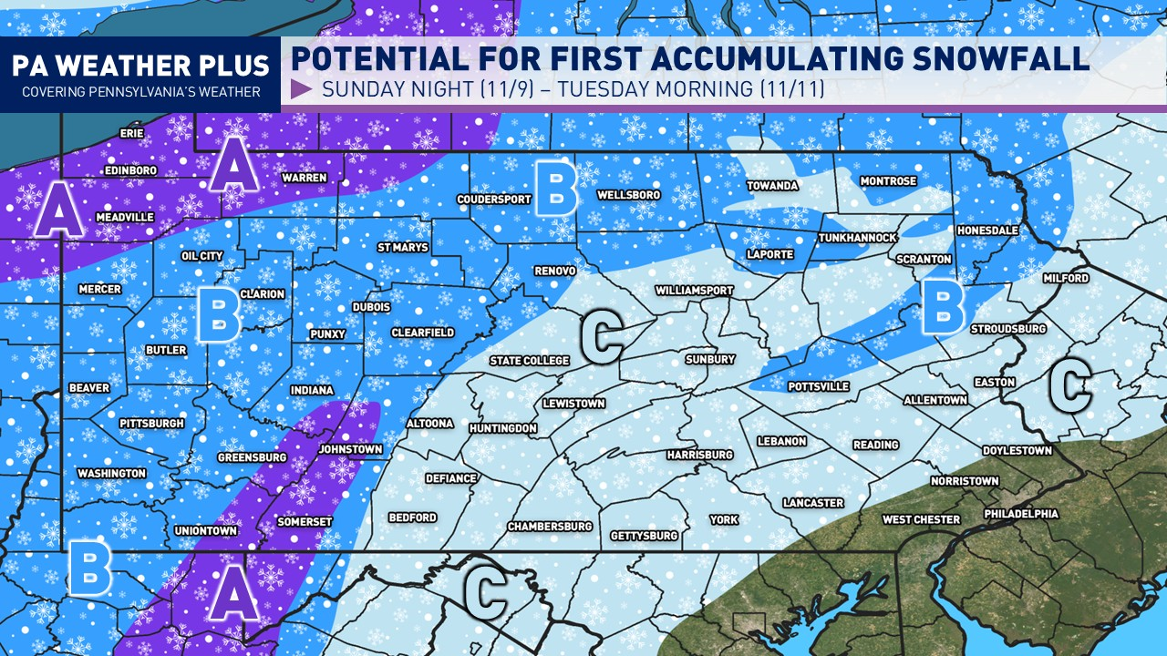
FIRST LOOK AT PENNSYLVANIA SNOW IMPACTS

With a few days to go, I will not release a snowfall map until Saturday afternoon at the earliest. This is meant to be a generic outline in which looking at areas may see accumulations versus just snow showers.
AREA A: Periods of lake effect (and mountain-induced snowfall) are expected through early portions of next week. Moderate snowfall accumulations possible. It will be a good idea to bring out your snow shovels and snow blowers to be prepared ahead of the possible snowfall accumulation.
AREA B: Periods of snow showers and snow squalls will be expected through early portions of next week. Light snowfall accumulations possible, mainly to just elevated and grassy surfaces. Some areas above 1700 FT within these zones may see moderate snowfall accumulations, but this will be better fine tuned closer to early next week.
AREA C: The first snow showers and squalls of the season are looking probable. No snowfall accumulations are anticipated at the time. Check back for updates throughout the weekend.
FOR MORE UPDATES, FOLLOW US ON FACEBOOK!
Share below to spread this weather update to your family, friends, etc, to keep them weather aware! I will have more updates and snowfall maps throughout the weekend.
-Meteorologist Denys Khrulov
Check out our other articles below: