The beginning of January has been a rather dud for winter weather fans across Pennsylvania. After a cold and snowy December, we have entered the stage of winter, coining it as “January thaw”. The January thaw will not last forever, as much as I know some of you would like for it to continue. I am tracking changes in the pattern as we head into the middle and latter part of the month and watching for a potential coastal storm next week!
JUMP TO THE FOLLOWING:
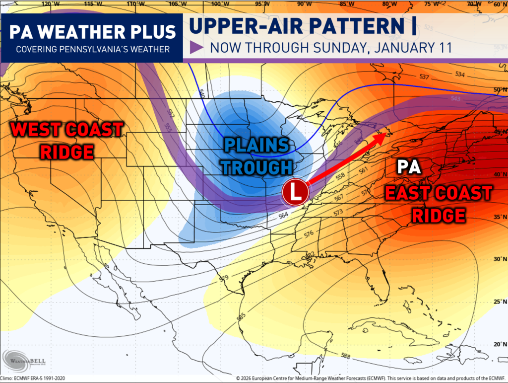
PATTERN THROUGH JANUARY 11:
Ridges on both U.S. coasts will dominate the pattern through the weekend, while a central U.S. trough remains in place.” Here in Pennsylvania, while we are under the ridge, we will continue to see above-average temperatures and predominantly rain.
One or two low-pressure systems will form along the Plains trough, producing periods of rain and possibly snow across Iowa, Wisconsin, Missouri, and Illinois. Here in Pennsylvania, we will see periods of rain on Friday and Saturday until the cold front with the trough pushes through, drying as out.
PATTERN SECOND WEEK OF JANUARY:
After the trough swings through, we will open up the second week of January with another pattern. The bulk of the trough will now be expected to linger across the eastern United States, including here in Pennsylvania. Given the trough position, it puts a favorable location for a potential low-pressure system to develop sometime next week off the East Coast.
UPPER-AIR PATTERN:
Now, before we get too excited, I am not expecting this to be a large winter storm. For one, this flow is rather “fast” without any strong blocking to the north. So if a storm develops (which I am leaning toward), it will appear to be a quick-mover. Although the exact strength will vary, a strong low pressure will bring more precipitation and vice-versa.
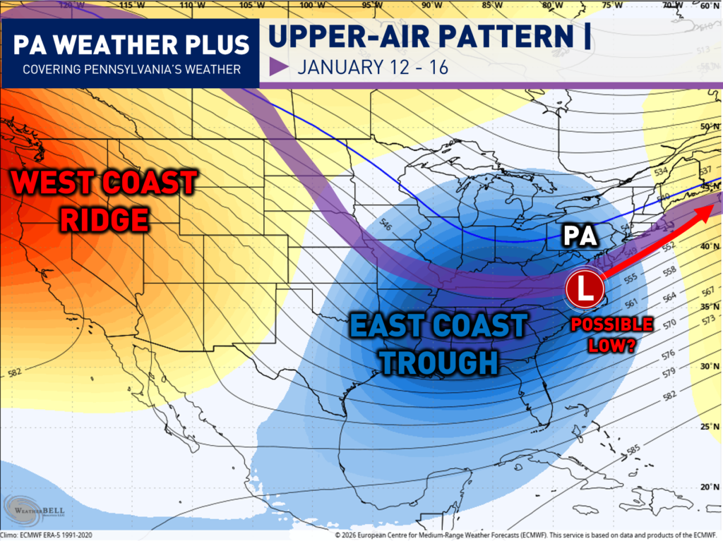
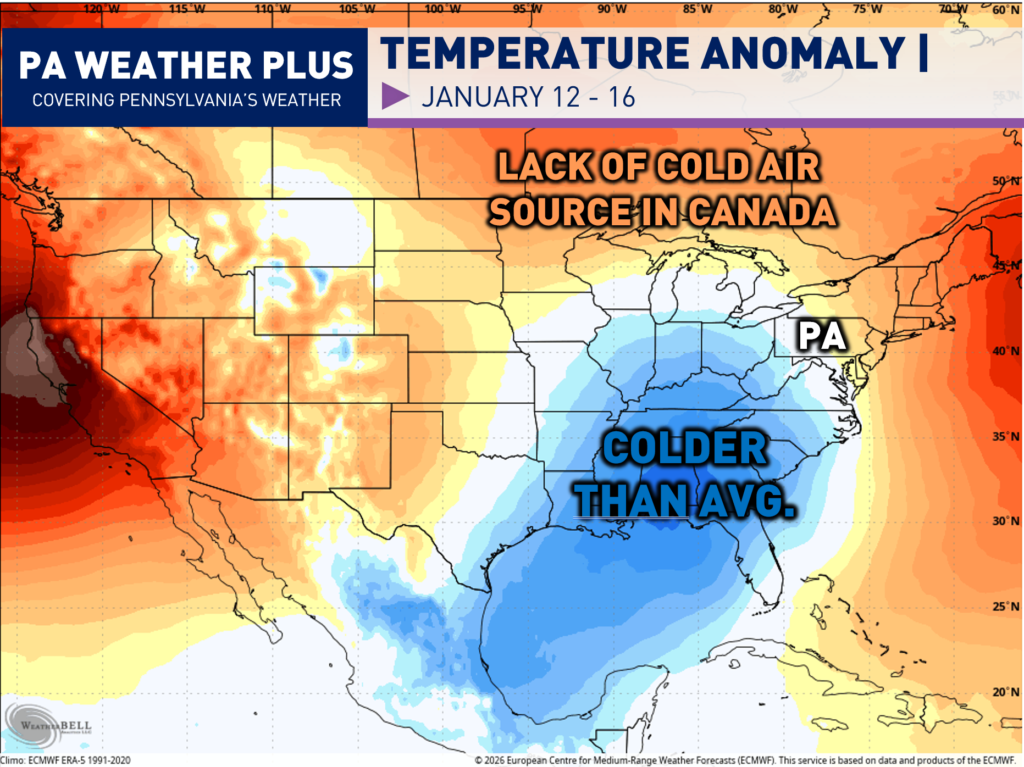
Now, secondly, there is a lack of a “true” source of cold air. These are temperature anomalies a few thousand feet off the surface (850MB). While much of the southeast and eastern United States is looking to be below average, this is not true cold air. Our source of cold air usually originates from Canada, and if a storm develops, it will be ingesting not-as-cold air.
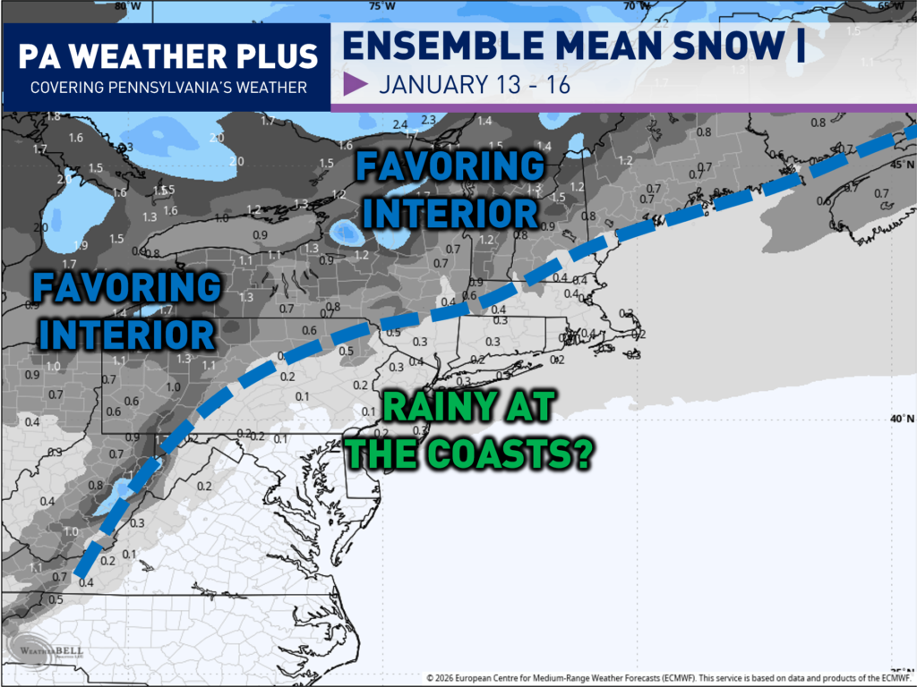
SNOW OR RAIN?
Therefore, the latest signal favors the far interior over the coasts *if* we can get a storm to develop. The lack of true blocking and cold air will not be favorable for a storm if you are south and east of the blue-dotted line. This includes much of central and eastern Pennsylvania, also with the I-95 corridor. The only expectation is that if we get a rather strong low to develop to generate its own colder air through dynamic cooling, but I am not favoring this scenario.
If a low-pressure system develops next week (looking favorable given the upper-air setup), I am expecting mostly a rain / wet interior snow event. If you were hoping for a large snowstorm, I wish I had better news, but unless we see significant changes in the sources of cold air, I do not foresee this changing.
MID – LATE JANUARY PATTERN:
I promised to do monthly outlooks throughout the winter & beyond, but I really ran out of time given the active end of December. And truthfully, while the pattern for January looked to be uncertain, I am finally beginning to gain confidence, given how the first week is beginning to pan out.
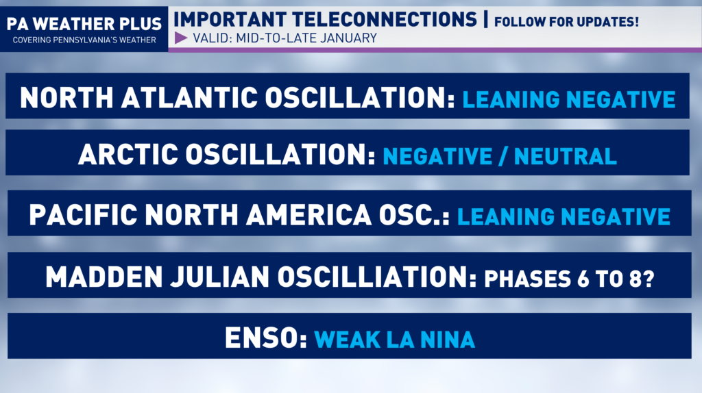
NORTH ATLANTIC OSCILLATION (NAO): Leaning Negative. This will lead to high-latitude blocking at times into mid to late January. This will help to ‘lock in’ colder blasts of air into the eastern United States. If timed perfectly, it could increase the risk for a larger storm.
ARCTIC OSCILLATION (AO): Negative to At Times Neutral: This will lead to blocking across the Arctic regions. This increases the risk for cold air blasts to infiltrate into the central and eastern United States.
PACIFIC NORTH AMERICAN OSCILLATION (PNA): Leaning Negative. This leads to more troughing across the western United States / North America. This usually leads to a less amplified pattern across the Eastern United States. It may even induce ridging across portions of the southeastern United States.
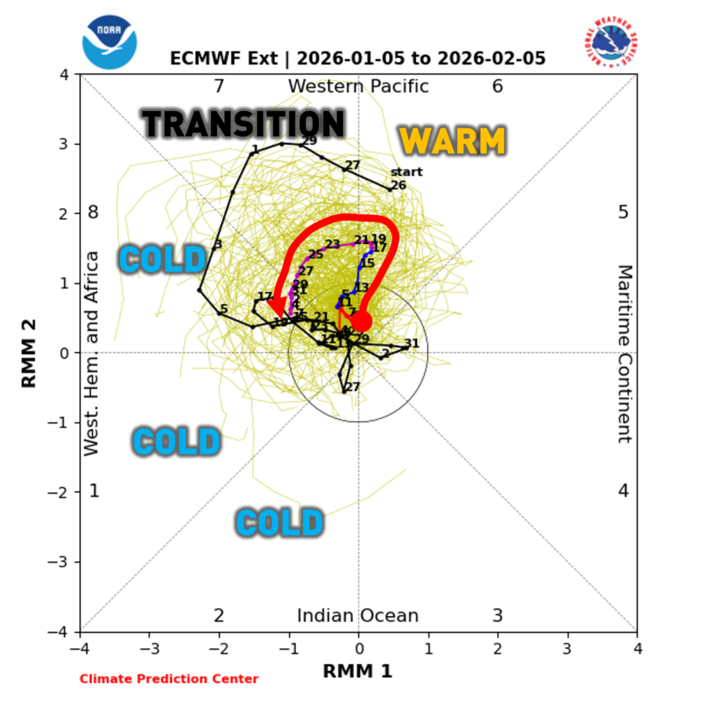
MADDEN JULIAN OSCILLATION (MJO) : PHASES 7 THROUGH 2. The MJO is different from the other teleconnections. It is numerically ordered as it tracks thunderstorm activity across the equator. This tracking occurs primarily from the Indian to eastern Pacific Ocean. It makes a full cycle every 30 – 90 days from Phase ‘1’ through Phase ‘8’. For us, the phases are favored to bring below-average temperatures to much of the eastern United States. Phases 8, 1, and 2 are favored cold. Phase 7 is a transition phase.
After a month of inactivity from the MJO, it is expected to “wake up” with increased upward motion and convection (thunderstorms) in Phase 6. These will propagate eastward, which will allow the MJO to head into the more active and colder phases for the East Coast into the latter half of January.
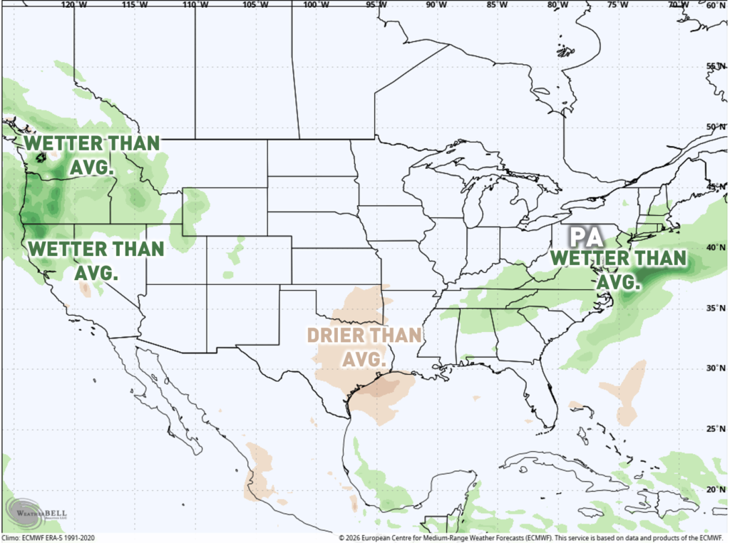
EXPECTED TEMPERATURES / PRECIPITATION MID-LATE JANUARY:
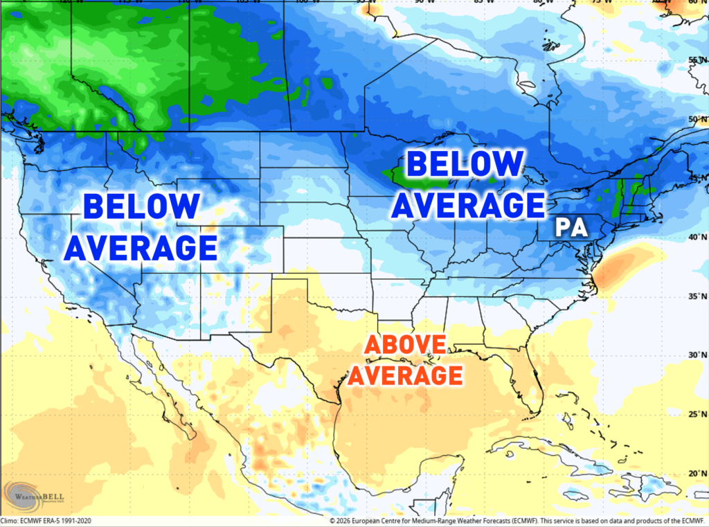
As we head into mid-to-late January, given the teleconnections and projected pattern, much of the Northeast, including here in Pennsylvania, should transition back to a colder-than-average pattern. Whether we see snow or precipitation overlap with the cold is still uncertain. It is hard to get larger precipitation winter events during a La Niña winter with a weaker sub-tropical jetstream. The ensemble guidance is hinting toward wetter-than-average conditions through the Mid-Atlantic and portions of the Northeast, so this could highlight the potential for an increased snow risk.
PENNSYLVANIA EXTENDED OUTLOOK:
| TIME PERIODS | TEMPERATURE | PRECIPITATION | SNOWFALL |
| JANUARY 7 – 11 | WELL ABOVE AVERAGE | ABOVE AVERAGE | LIKELY NO SNOW EVENTS. |
| JANUARY 12 – 16 | SLIGHTLY ABOVE AVERAGE | NEAR / BELOW AVERAGE | WATCHING COASTAL, INLAND FAVORED. |
| JANUARY 17 – 21 | SLIGHTLY BELOW AVERAGE | NEAR AVERAGE | CLIPPERS / LAKE EFFECT |
| JANUARY 22 – 26 | BELOW AVERAGE | NEAR AVERAGE | CLIPPERS / MINOR (OR MODERATE) EVENT |
| JANUARY 27 – 30 | BELOW AVERAGE | LEANING ABOVE AVERAGE | WATCHING NEXT RISK FOR LARGER STORM |
THANK YOU! Thank you for taking the time to read this! I personally don’t like making seasonal forecasts as they are hard to verify. Small changes in the pattern can throw off an entire long-range forecast. Stay tuned for forecast updates on social media! If you are not following on Facebook, feel free to drop a follow here! FOLLOW PA WEATHER PLUS ON FACEBOOK