The coldest air of the season is on the way to Pennsylvania this weekend as a strong blast of arctic air arrives out of northern Canada. An arctic front will sweep through the state Friday night into Saturday morning, increasing the wind gusts and significantly lowering the temperatures. Due to the higher wind gusts, isolated or scattered power outages may be possible. This is something to take seriously in case of emergencies such as power outages or a car breakdown as the cold could easily make your situation life-threatening. Please take proper precautions this weekend and stay warm!
PENNSYLVANIA WIND CHILL ALERTS:
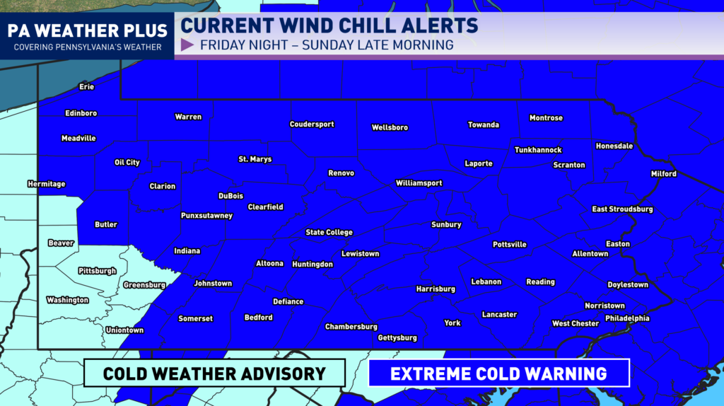
Pennsylvania Extreme Cold Warnings: Frostbite may occur in as little as 15 – 30 minutes or in some instances less to exposed skin.
Counties in effect: Adams, Armstrong, Bedford, Berks, Blair, Bradford, Butler, Cambria, Cameron, Carbon, Centre, Chester, Clarion, Clearfield, Clinton, Columbia, Crawford, Cumberland, Dauphin, Delaware, Elk, Franklin, Fulton, Huntingdon, Indiana, Juniata, Lackawanna, Lancaster, Lebanon, Lehigh, Luzerne, McKean, Mercer, Mifflin, Monroe, Montour, Northampton, Northumberland, Perry, Philadelphia, Pike, Potter, Schuylkill, Snyder, Somerset, Sullivan, Susquehanna, Tioga, Union, Venango, Warren, Westmoreland, Wyoming, and York Counties
Pennsylvania Cold Weather Advisories: Frostbite may occur in as little as 25 – 45 minutes or in some instances less to exposed skin.
Countes in effect: Allegheny, Beaver, Fayette, Greene, Washington, and Westmoreland Counties.
PENNSYLVANIA WIND CHILL FORECASTS:
WIND CHILL LATE FRIDAY NIGHT – SATURDAY MORNING:
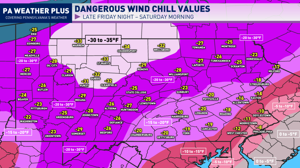
Little improvement is expected Saturday afternoon, with widespread wind chill values of -10 to -25 across the state during the “warmest” part of the day. Actual air temperatures will be in the single digits for most locations, perhaps a few low-tens.
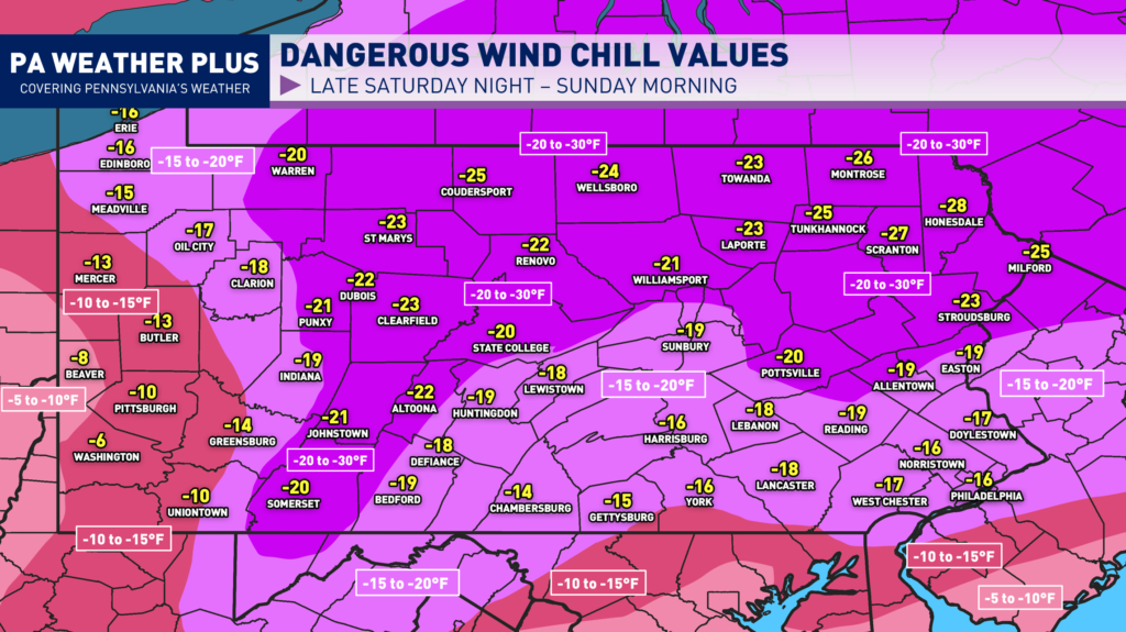
WIND CHILL LATE SATURDAY NIGHT – SUNDAY MORNING:
When wind chill values drop this low, the cold air can affect your body much faster. Strong winds pull heat away from exposed skin, which greatly increases the risk of frostbite and hypothermia. Even temperatures that don’t seem extreme can become dangerous when combined with wind, so it’s important to take precautions anytime wind chills fall near or below zero.
If you are planning to be outdoors Friday night through Saturday and even into Sunday take precautions. Make sure to dress in multiple loose-fitting layers to trap heat and stay dry. Start with a moisture-wicking base layer, add an insulating middle layer like fleece or wool, and finish with a windproof and waterproof outer shell. Cover exposed skin as much as possible. Do this by wearing a hat, gloves, a scarf, and insulated, waterproof boots with thick socks. Hands, ears, nose, and cheeks are usually the first areas to develop frostbite.
I have a page on the website dedicated to giving you a more accurate timing forecast for your given location and an air temperature hour-by-hour forecast. Check it out here! Your Local Weather
PENNSYLVANIA HIGH WIND GUSTS / POWER OUTAGES:
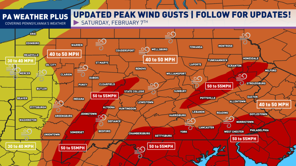
RED ZONE: Peak wind gusts 50 – 55 MPH. A few gusts up to 60 MPH are not ruled out. Damaging wind gusts could blow down trees and power lines. This may result in scattered power outages. High winds may make travel difficult, especially in high-profile vehicles. Non-secured objects and trash cans will be blown away.
ORANGE ZONE: Peak wind gusts 40 – 50 MPH. A few gusts over 50 MPH are not ruled out. Higher wind gusts may result in a few downed trees and power lines. This may result in isolated to scattered power outages. Non-secured objects may be blown around.
YELLOW ZONE: Peak wind gusts 30 – 40 MPH. A few gusts over 40 MPH are not ruled out. Issues are generally not expected, although brief higher gusts may down a tree or two. Power outages are not expected but may occur in an isolated instance.
DANGEROUS COLD PRECAUTION TIPS:
Take extra precautions during this period of extreme cold and strong winds, as higher gusts may cause scattered power outages. Limit your time outdoors and wear multiple warm layers, including a hat, gloves, and insulated footwear, to reduce the risk of frostbite and hypothermia. Charge your phones, portable batteries, and any essential medical devices before the worst conditions arrive. Keep flashlights, extra blankets, bottled water, and non-perishable food easily accessible in case the power goes out.
Never use generators, grills, or propane heaters indoors. Do not run vehicles inside garages because they produce dangerous carbon monoxide. Secure loose outdoor objects so the wind cannot blow them around. Check on older neighbors, young children, and pets who are more vulnerable to the cold. If you lose power, close off unused rooms and keep doors and windows shut to conserve as much indoor heat as possible. In the worst case scenario, make sure you are able to locate a warming center in your community and/or a hotel with heat and power.
Stay tuned and stay safe! For more updates, don’t forget to follow PA Weather Plus on Facebook!-Denys