Estimated reading time: 5 minutes
We start out the weekend on the beautiful and calm side with high pressure in control. This will all come crashing to an end by Sunday afternoon and evening. A strong cold front will move into the Ohio Valley and Great Lakes region. It will bring gusty winds and potentially a few heavier downpours. These heavier downpours will make their way into eastern Pennsylvania by the morning commute on Monday.
FEEL FREE TO JUMP TO THE FOLLOWING:
OVERALL ATMOSPHERIC SETUP:
We have two pieces of energy on the board that will be developing across the western United States. The northern piece will dive south. Meanwhile, the southern piece will move north. This movement will allow for a ‘storm phase’ to occur. As the phase occurs across the mid Ohio Valley, a stronger low pressure system and cold front will develop. This will head in our direction, bringing in low-end impacts Sunday and Sunday night. If this were winter, a significant winter storm would impact areas of Illinois, Indiana, and Michigan!


FUTURE SIMULATED RADAR:
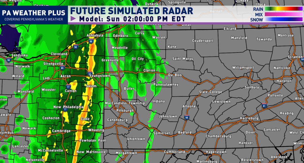
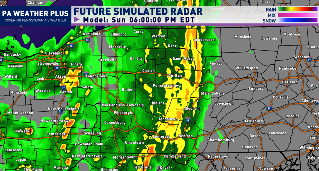
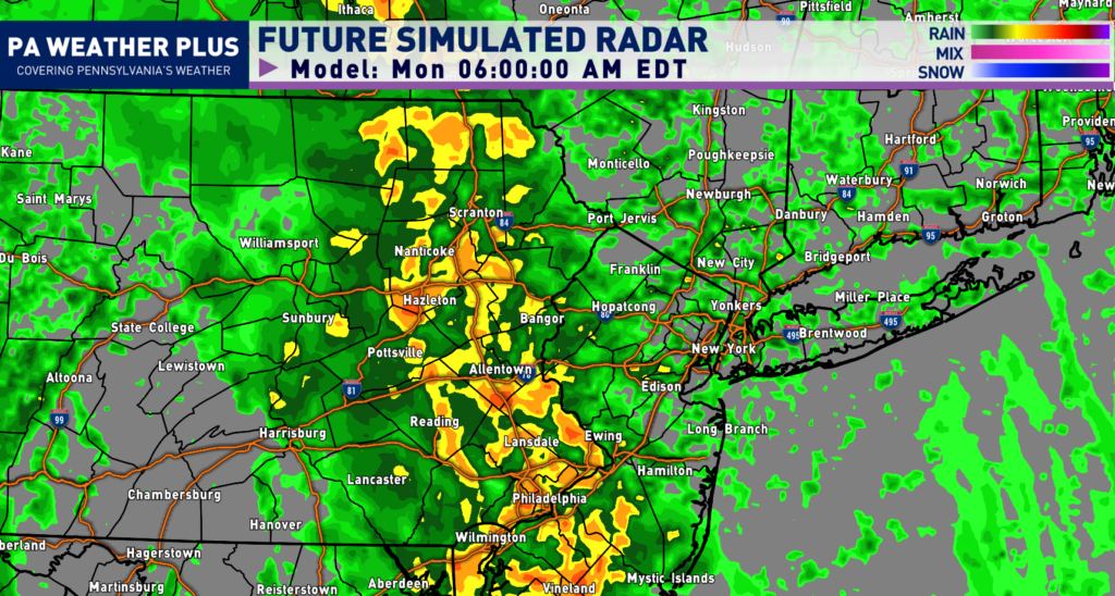
Disclaimer: Keep in mind, these are simulated radar projections. They use high-res modeling. They may not be exactly 1:1 to what occurs from Sunday through Monday night.
The majority of the morning is slated to be dry. Showers and rumbles of thunder will start moving toward western Pennsylvania. This will happen by early Sunday afternoon. These should generally be moving west-to-east.
By the mid-afternoon hours, the line will be moving through much of western Pennsylvania. Some of these downpours can be locally on the heavier side. However, the fast movement should prevent the risk of flooding.

Toward the evening and sunset hour, the line will now be moving in central Pennsylvania. Remnant showers are expected to hang around western Pennsylvania. These showers will continue to move eastward throughout the night as our low pressure system moves eastward.
By Monday morning, the cold front will be making its way into eastern Pennsylvania. Expect heavier downpours for the morning commute in cities such as Scranton, Allentown, and Philadelphia.
For a more definitive timing for your location, check out the Your Local Weather page!
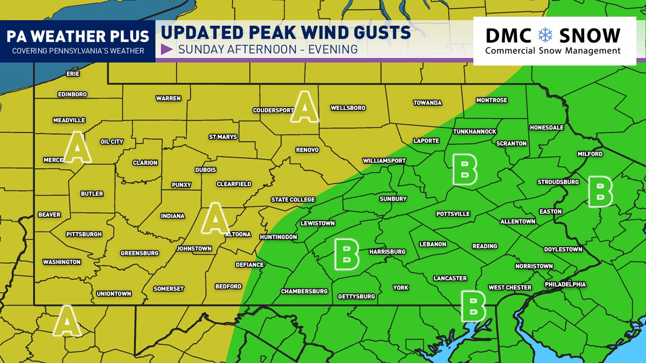
HIGHEST WIND GUST FORECAST:
Sunday will be a windy day, regardless of the expected rain showers and rumbles of thunder. The strengthening low pressure system and cold front will tighten the ‘pressure gradient’ on the surface. This will allow for these stronger wind gusts. With leafed trees, higher wind gusts pose for isolated power outages. We saw this issue occur across portions of Northeastern Pennsylvania on Wednesday with greater than 30 MPH wind gusts. If you live in an area prone to power outages, be cautious. Pay attention to the wind gusts on Sunday afternoon and evening!

AREA A: Wind gusts up to 30 – 40 mph. Isolated wind gusts upward to 45 mph. Isolated downed trees and isolated power outages are expected. If you are in an area prone to power outages, be aware.
AREA B: Wind gusts up to 20 – 30 mph. Isolated wind gusts up to 40 mph. Downed trees and power outages are generally not expected.
PENNSYLVANIA RAINFALL FORECAST:

These are the rainfall projections through Monday afternoon. The majority of the rain for western and central Pennsylvania will come late Sunday through Monday morning. For eastern Pennsylvania, the majority of the rain will come Sunday night through Monday afternoon. The heaviest rainfall amounts will be across western Pennsylvania. A second rainfall maxima across northeastern Pennsylvania as we see a re-development of the low pressure system. Cities like Erie and Pittsburgh will see upwards of an inch of rainfall or more. The same story holds for Scranton and nearby towns/cities.
REMEMBER: For a more in-depth forecast based on your location, please visit https://paweatherplus.com/your-local-weather/. This page was created with NWS/NOAA data and will give you a more in-depth forecast!
Key Takeaways
- This weekend starts calm but a strong cold front will bring gusty winds and downpours by Sunday evening.
- A low pressure system will develop as two energy pieces move across the western U.S., impacting areas by Sunday night.
- Expect rain starting Sunday afternoon in western Pennsylvania, with heavier downpours moving eastward by Monday morning commute.
- Wind gusts may reach 30-45 mph in some areas, risking downed trees and isolated power outages.
- Heaviest rainfall will hit western Pennsylvania, with some cities receiving over an inch by Monday afternoon.
FOR MORE UPDATES, FOLLOW US ON FACEBOOK!
Share below to spread this weather update to your family, friends, etc, to keep them weather aware!
-Meteorologist Denys Khrulov