Estimated reading time: 5 minutes
Not much has changed from this last night’s second call forecast. A snow event is heading for many of us here in Pennsylvania, starting this afternoon. Those who have missed out over the last few weeks will make up for the snow deficit, including areas of southwestern and southeastern Pennsylvania. The trend has been for higher amounts with a more amplified system. Let’s dig into the details for the winter storm!
The snowfall map is within the ‘final call’ portion of the blog toward the very bottom.
If you missed the second call forecast, check it out here: https://paweatherplus.com/pennsylvania-weekend-winter-system-second-call-forecast
CLICK TO THE FOLLOWING:
METEOROLOGICAL SETUP:
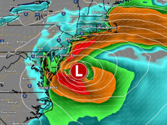
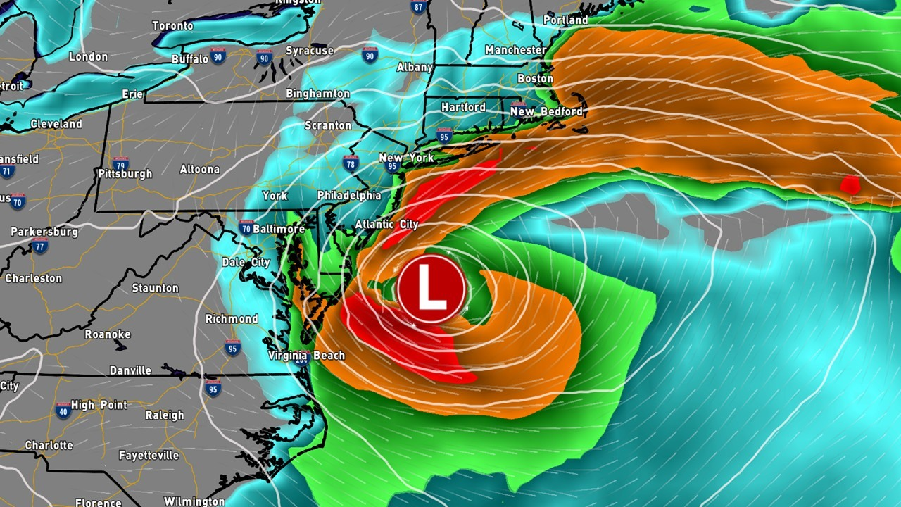
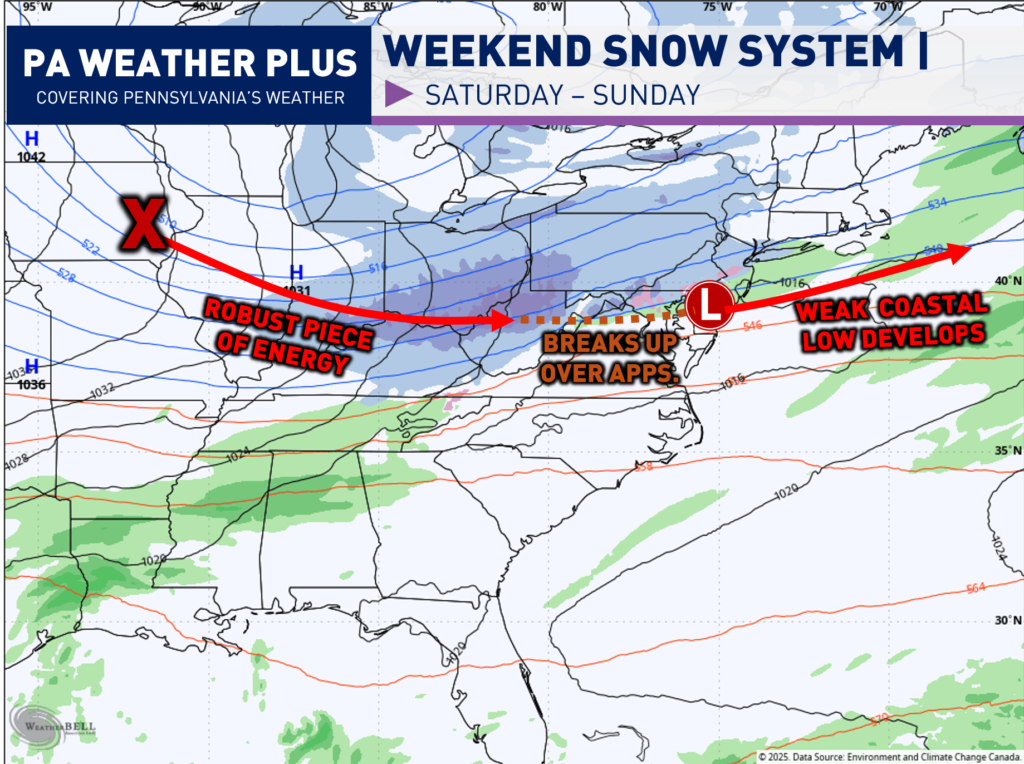
What is going on with this system? A robust piece of energy will be digging out of the central United States ahead of a potent arctic blast. This will bring a swath of 3 to 6 inches of snow from Illinois to Ohio. This piece of energy will ram against the Appalachian Mountains and “fall apart”. This is why much of central Pennsylvania will see limited snowfall amounts. By the time it makes it over, it will transfer its energy to a weak coastal low that develops and will increase the snowfall amounts across Philadelphia and southeastern Pennsylvania.
Depending on the position of the coastal slow, the snowfall amounts across southeastern Pennsylvania will be highly impacted. The trend has more toward a more amplified, tucked in coastal system, which has increased amounts across much of eastern Pennsylvania. This is becoming a winter storm.
WINTER WEATHER ROAD CONDITIONS & TIMING:
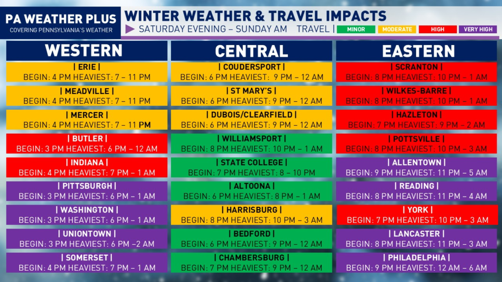
VERY HIGH: Widespread snow and/or ice will cover nearly all roadways, including major highways and interstates. Winter storm conditions expected. Travel conditions will be extremely dangerous, and becoming stranded is possible, especially during the steadiest period of snowfall. Travel may be impossible at times and is strongly discouraged.
HIGH: Snow and/or ice will affect most roadways and many highways and interstates. Hazardous driving conditions are expected, with an increased risk for accidents. Non-essential travel is discouraged.
MODERATE: Snow and/or ice may impact scattered roadways and some highways. While conditions are less severe, accidents are still possible—especially during lighter or intermittent precipitation. Use caution, slow down, and allow extra travel time.
MINOR: Isolated snow- and/or ice-covered roads are possible. While impacts are limited, slick spots can still develop. Remain alert, reduce speeds, and drive with caution.
I have a page on the website dedicated to giving you a more accurate timing forecast for your given location, check it out here! Your Local Weather
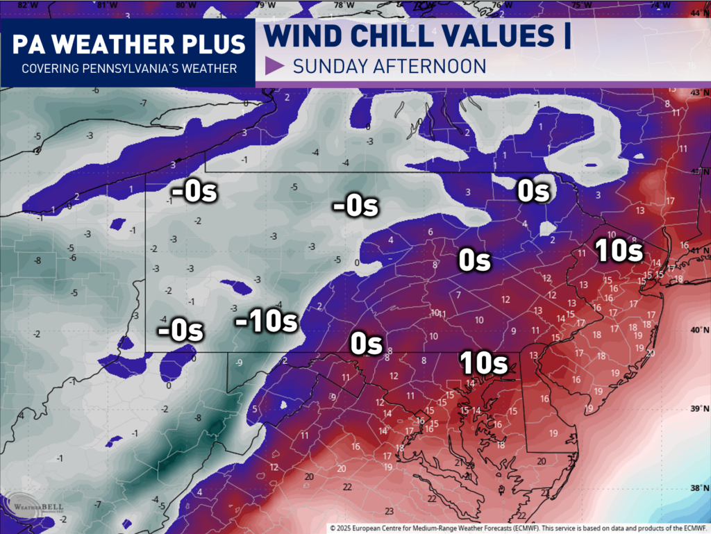
FRIGID COLD BEHIND THE STORM:
Behind the storm, we will have to deal with lake effect snow showers and snow squalls. With that, a much colder blast of air will move in. Wind chill values Sunday afternoon will be in the negatives for much of western Pennsylvania with single digits to lower teens for eastern Pennsylvania. Everything that falls Saturday night into Sunday morning will not freeze.
Below will be the final call snowfall forecast for this impending winter storm!
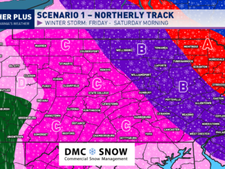
FINAL CALL PENNSYLVANIA SNOWFALL FORECAST:
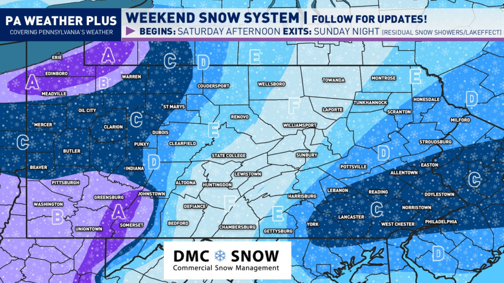
NOTE: This snowfall map will include the additional lake effect expected across northwestern PA.
AREA A: 9 to 16 inches of snow expected, isolated higher amounts up to 24″ not ruled out (primarily lake effect). In northwestern Pennsylvania, the heaviest snow will occur with the lake effect Sunday afternoon through early Monday morning. Expect major road delays with snow-covered roadways. Travel may become impossible at times of heavier lake effect snow bands. I would highly recommend halting travel during the duration of the winter event.
AREA B: 6 to 9 inches of snow expected. Widespread snow-covered roads and interstates are likely. I would highly recommend halting travel during the duration of the winter event.
AREA C: 4 to 6 inches of snow expected. Numerous snow-covered roads and interstates are likely. Travel is highly unrecommended during the steadiest periods of snow.
AREA D: 2 to 4 inches of snow expected. Snow-covered roadways and interstates are expected during the steadiest periods of snow. Monitor conditions before travelling and try to do so before or after the event.
AREA E: 1 to 2 inches of snow expected. With cold temperatures, a few snow-covered roadways and interstates are possible. Monitor conditions before travelling and try to do so before or after the event.
AREA F: Up to 1 inch of snow expected. With cold temperatures, a few roadways may become briefly covered during a steady snow shower. Monitor conditions before you travel.
CONCLUSION:
This will be the final blog post update regarding this storm. I will continue to post trends and information regarding the storm on Facebook and other social media pages, so make sure to follow the page on Facebook. If you are planning to travel, please do so before or after the storm. With cold surface temperatures, it will not take a lot of time to produce snow-coverd roadways and interstates. Stay tuned!
-Meteorologist Denys K