Not much has changed from this morning’s first call forecast. A snow event is heading for many of us here in Pennsylvania this weekend. Those who have missed out over the last few weeks will make up for the snow deficit, including areas of southwestern and southeastern Pennsylvania. Let’s dig into the details!’
If you missed the first call forecast, you can find it here: https://paweatherplus.com/weekend-snow-system-brings-snow-to-much-of-pennsylvania/
JUMP TO THE FOLLOWING:
Estimated reading time: 6 minutes
METEOROLOGICAL SETUP:
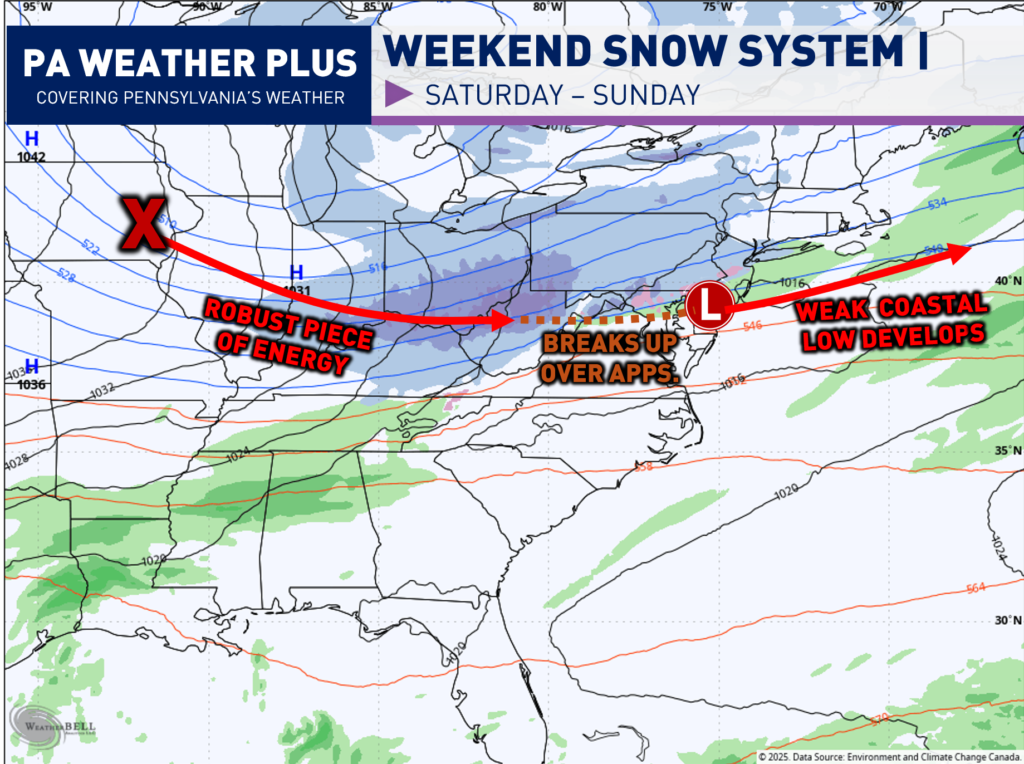
What is going on with this system? A robust piece of energy will be digging out of the central United States ahead of a potent arctic blast. This will bring a swath of 3 to 6 inches of snow from Illinois to Ohio. This piece of energy will ram against the Appalachian Mountains and “fall apart”. This is why much of central Pennsylvania will see limited snowfall amounts. By the time it makes it over, it will transfer its energy to a weak coastal low that develops and will increase the snowfall amounts across Philadelphia and southeastern Pennsylvania.
Depending on the position of the coastal slow, the snowfall amounts across southeastern Pennsylvania will be highly impacted. A more tightly condensed inland low will bring the swath of 4 to 6 inches farther inland and more widespread. A weaker, flatter low will bring the 4 to 6 inches farther south. I am still leaning toward it coming a good bit northwest, but it will be important to watch trends over the next 12 – 24 hours.
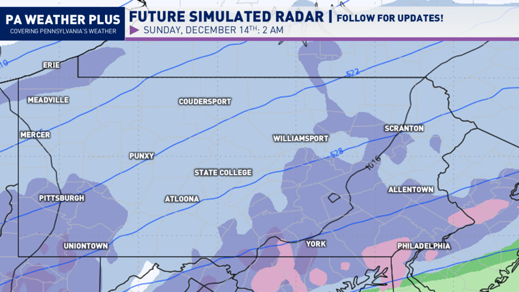
SIMULATED WINTER RADAR:
SATURDAY AFTERNOON / EVENING:
Snow will begin to overspread portions of western Pennsylvania by mid-to-late afternoon Saturday. The snow will begin generally on the lighter side. Areas such as Pittsburgh, Meadville, and Erie will see snow first.
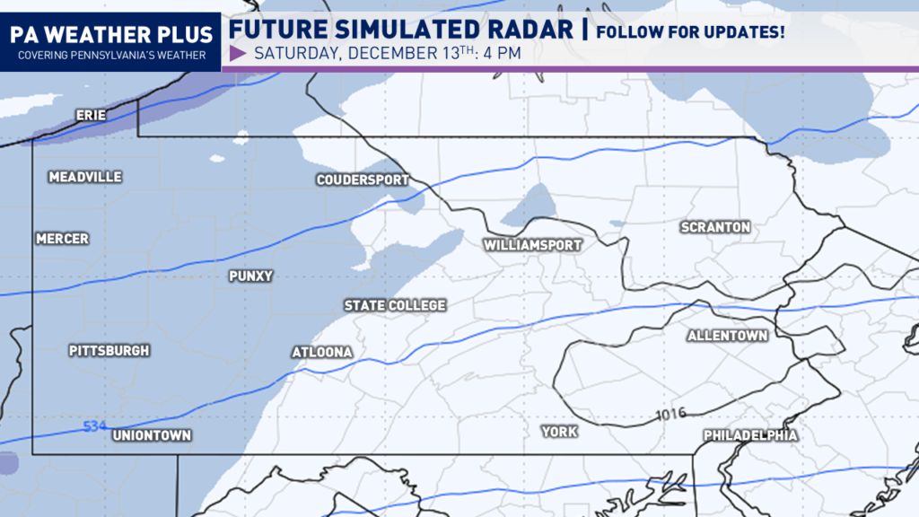
As we get farther into the evening, snow will overspread the state west-to-east. The snow will be the steadiest across southwestern Pennsylvania, putting Pittsburgh in the steadiest snow.
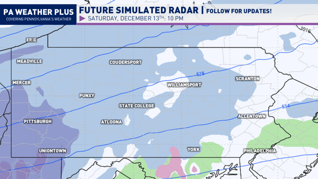
By the overnight hours, steady snow will continue to fall across southwestern Pennsylvania. Snow will begin to overspread much of eastern Pennsylvania, turning steady at times as well.
EARLY SUNDAY THROUGH THE AFTERNOON:
By the time Sunday morning rolls around, the steadiest snow will be falling across southeastern Pennsylvania. The snow could be falling moderately to perhaps briefly heavy, especially in/around Philadelphia. The rest of the state will begin to see the snow slowly taper off.
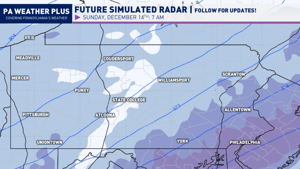
Heading into the early afternoon, much of the snow will now be exiting eastern Pennsylvania. Lingering snow showers and snow squalls due to lake effect will continue across much of western and especially northwestern Pennsylvania. Much of the overall snow system begins to come to an end by here.

I have a page on the website dedicated to giving you a more accurate timing forecast for your given location, check it out here! Your Local Weather
WINTER WEATHER ROAD CONDITIONS & TIMING:
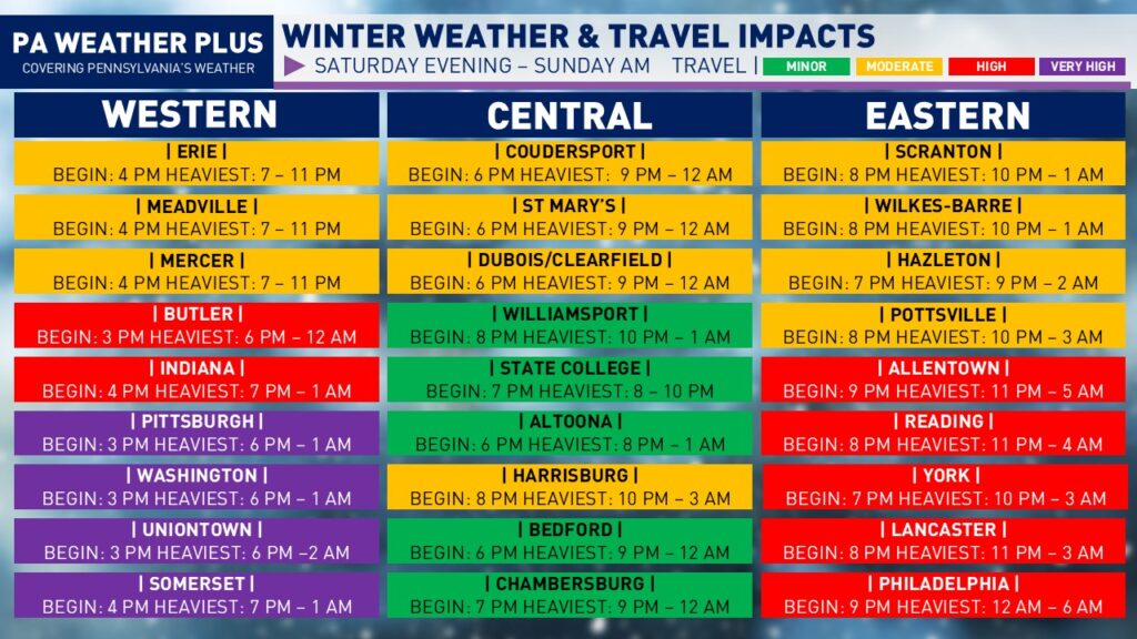
NOTE: These travel impacts are solely from the synoptic snow system and do not include the lake effect.
VERY HIGH: Almost all roadways including highways/interstates will be snow or ice-covered. You may become stranded on some routes. Travel may be impossible at times. Travel is *HIGHLY* unrecommended.
HIGH: Most roadways and numerous highways/interstates will be snow or ice-covered. Be on alert for numerous accidents. Travel unrecommended.
MODERATE: Scattered roadways and a few highways/interstates may be snow or ice-covered. Be on alert for potential accidents. Lighter snowfall or ice events cause a higher percentage of accidents. Travel safely and reduce speeds.
MINOR: A few snow or ice-covered roadways will be possible. Be on alert for potential accidents. Lighter snowfall or ice events cause a higher percentage of accidents. Travel safely and reduce speeds.
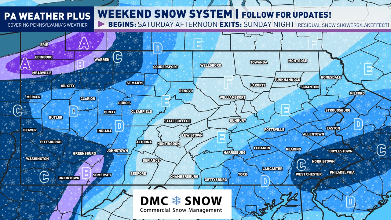
SECOND CALL PENNSYLVANIA SNOWFALL MAP:

NOTE: These snowfall maps will include the additional lake effect expected across northwestern PA.
AREA A: 10 to 16 inches of snow expected. The heaviest snow will occur with the lake effect Sunday afternoon through early Monday morning. Expect major road delays with snow-covered roadways. Travel may become impossible at times of heavier lake effect snow bands. I would highly recommend halting travel during the duration of the winter event.
AREA B: 6 to 10 inches of snow expected. Widespread snow-covered roads and interstates are likely. I would highly recommend halting travel during the duration of the winter event.
AREA C: 4 to 6 inches of snow expected. Numerous snow-covered roads and interstates are likely. Travel is highly unrecommended during the steadiest periods of snow.
AREA D: 2 to 4 inches of snow expected. Snow-covered roadways and interstates are expected during the steadiest periods of snow. Monitor conditions before travelling and try to do so before or after the event.
AREA E: 1 to 2 inches of snow expected. With cold temperatures, a few snow-covered roadways and interstates are possible. Monitor conditions before travelling and try to do so before or after the event.
AREA F: Up to 1 inch of snow expected. With cold temperatures, a few roadways may become briefly covered during a steady snow shower. Monitor conditions before you travel.
Stay tuned for updates! There are still some changes that could occur, which will lead to either an amplification of the storm system (higher amounts) or a trend of weaker and bring lower amounts. There are two local maxima with this event as it falls apart over the Appalachian Mountains in central Pennsylvania and regenerates across eastern Pennsylvania with a coastal influence. Make sure to share with friends and family so they are well-informed ahead of this risk!
-Meteorologist Denys K
A final call snowfall forecast and impacts blog will be released by late Saturday morning.