Estimated reading time: 7 minutes
We’ve had quite the active week thus far between light snow systems and blasts of colder air. The pattern is not done quite yet, and the weekend storm has been on my watch since last weekend. Since the pattern is very progressive, it is hard to get larger winter storms. Instead, we are “nickel and diming” our way this December, and this weekend does not appear to change that. What does this change with this event is that many areas that have missed out on snow this season will begin to cash in!
If you missed the potential scenarios, feel free to read here: https://paweatherplus.com/weekend-snow-system-scenarios-for-pennsylvania/
JUMP TO THE FOLLOWING:
METEOROLOGICAL SETUP:
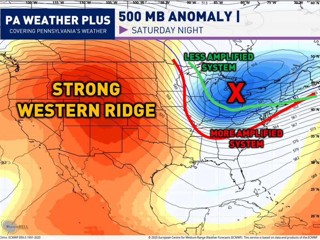
The 500mb layer of the atmosphere (18,000 feet above the ground) is one of the most important in regard to steering weather patterns. The 500mb level is high enough to be above local surface features (terrain, friction, local temperature variations) but low enough to stay connected to weather systems. Then, vorticity is just a fancy meteorology term that means spin in the atmosphere. More vorticity equals more spin, which equals more disturbed weather and vice versa.
In terms of this system, I am watching how much the trough can “dig” across the eastern United States. A large piece of energy will be coming out of the Plains and interacting with the tropospheric polar vortex (very cold air), allowing for an all-snow event.
A “flatter” trough (green line) will lead to a less amplified and much weaker system. A “deeper” trough (red line) will lead to a more amplified and stronger system. The scenarios are not that extreme, but I drew those two to envision the differences.
The strength of the western ridge will have an impact as this pattern is like a “see-saw”. The higher the up is out west, the lower the down will be down east. We are still 36 – 48 hours from impacts, so changes will more than likely continue to still occur!
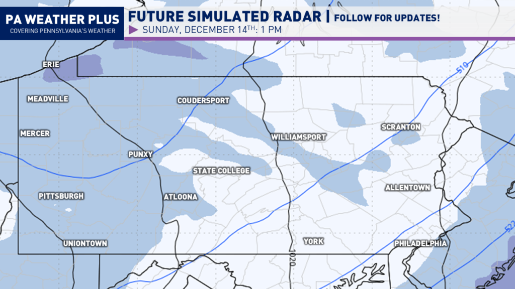
SIMULATED WINTER RADAR:
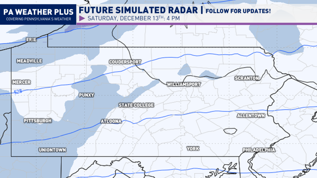
LATE SATURDAY AFTERNOON / EVENING:
Snow will begin to overspread portions of western Pennsylvania by mid-to-late afternoon Saturday. The snow will begin generally on the lighter side. Areas such as Pittsburgh, Meadville, and Erie will see snow first.
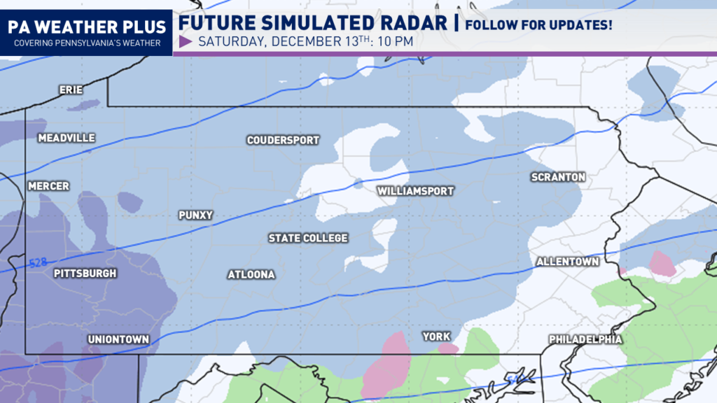
As we get farther into the evening, snow will overspread the state west-to-east. The snow will be the steadiest across southwestern Pennsylvania, putting Pittsburgh in the steadiest snow.
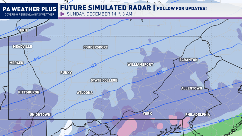
By the overnight hours, steady snow will continue to fall across southwestern Pennsylvania. Snow will begin to overspread much of eastern Pennsylvania, turning steady at times as well.
EARLY SUNDAY THROUGH THE AFTERNOON:
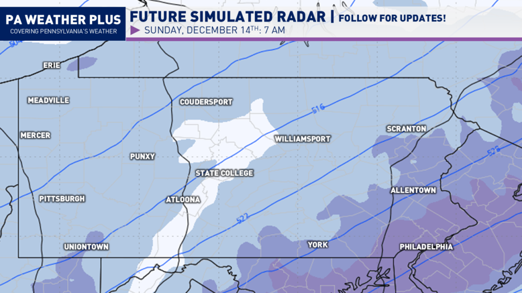
By the time Sunday morning rolls around, the steadiest snow will be falling across southeastern Pennsylvania. The snow could be falling moderately to perhaps briefly heavy, especially in/around Philadelphia. The rest of the state will begin to see the snow slowly taper off.
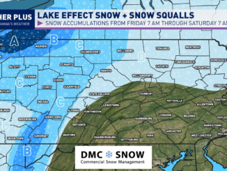
Heading into the early afternoon, much of the snow will now be exiting eastern Pennsylvania. Lingering snow showers and snow squalls due to lake effect will continue across much of western and especially northwestern Pennsylvania. Much of the overall snow system begins to come to an end by here.
I have a page on the website dedicated to giving you a more accurate timing forecast for your given location, check it out here! Your Local Weather
WINTER WEATHER ROAD CONDITIONS & TIMING:
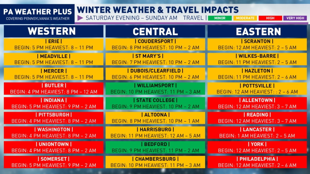
NOTE: These travel impacts are solely from the synoptic snow system and do not include the lake effect.
HIGH: Most roadways and numerous highways/interstates will be snow or ice-covered. Be on alert for numerous accidents. Travel unrecommended.
MODERATE: Scattered roadways and a few highways/interstates may be snow or ice-covered. Be on alert for potential accidents. Lighter snowfall or ice events cause a higher percentage of accidents. Travel safely and reduce speeds.
MINOR: A few snow or ice-covered roadways will be possible. Be on alert for potential accidents. Lighter snowfall or ice events cause a higher percentage of accidents. Travel safely and reduce speeds.
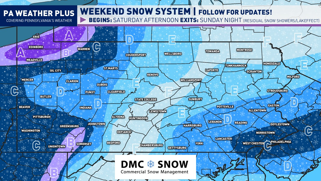
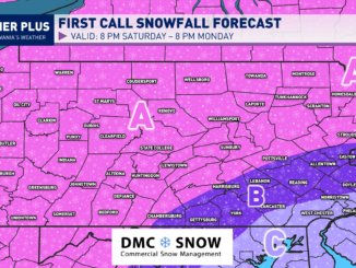
FIRST CALL PENNSYLVANIA SNOWFALL FORECAST:

NOTE: These snowfall maps will include the additional lake effect expected across northwestern PA.
AREA OF HIGHEST UNCERTAINTY: Southeastern Pennsylvania is highly uncertain, as it will be dependent on how quickly the coastal features develop. I can see the 4-6″ zone expand northwest or shrink southeastward, dependent on the track of the coastal features.
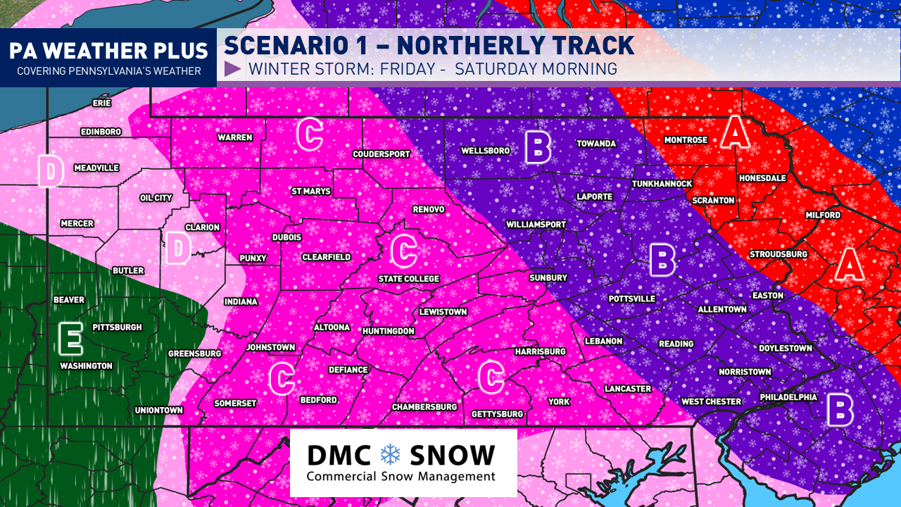
AREA A: 10 to 16 inches of snow expected. The heaviest snow will occur with the lake effect Sunday afternoon through early Monday morning. Expect major road delays with snow-covered roadways. Travel may become impossible at times of heavier lake effect snow bands. I would highly recommend remaining off of roadways.
AREA B: 6 to 10 inches of snow expected. Widespread snow-covered roads and interstates are likely. I would highly recommend remaining off of roadways.
AREA C: 4 to 6 inches of snow expected. Numerous snow-covered roads and interstates are likely. Travel is highly unrecommended during the steadiest periods of snow.
AREA D: 2 to 4 inches of snow expected. Snow-covered roadways and interstates are expected during the steadiest periods of snow. Monitor conditions before travelling and try to do so before or after the event.
AREA E: 1 to 2 inches of snow expected. With cold temperatures, a few snow-covered roadways and interstates are possible. Monitor conditions before travelling and try to do so before or after the event.
AREA F: Up to 1 inch of snow expected. With cold temperatures, a few roadways may become briefly covered during a steady snow shower. Monitor conditions before you travel.
Stay tuned for updates! There are still some changes that could occur, which will lead to either an amplification of the storm system (higher amounts) or a trend weaker and bring lower amounts. There are two local maxima with this event as it falls apart over the Appalachian Mountains in central Pennsylvania and regenerates across eastern Pennsylvania with a coastal influence. Make sure to share with friends and family so they are well-informed ahead of this risk!
-Meteorologist Denys K
A second call forecast will be released Friday evening with a final call snowfall forecast sometime Saturday morning.