Estimated reading time: 4 minutes
We’ve had quite the active week thus far between light snow systems and blasts of colder air. The pattern is not done quite yet, and the weekend storm has been on my watch since last weekend. Since the pattern is very progressive, it is hard to get larger winter storms. Instead, we are “nickel and diming” our way this December, and this weekend does not appear to change that.
JUMP TO THE FOLLOWING:
METEOROLOGICAL SETUP:
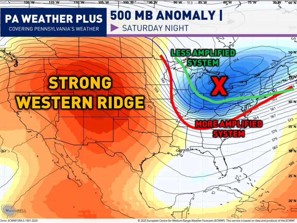
The 500mb layer of the atmosphere (18,000 feet above the ground) is one of the most important in regard to steering weather patterns. The 500mb level is high enough to be above local surface features (terrain, friction, local temperature variations) but low enough to stay connected to weather systems. Then, vorticity is just a fancy meteorology term that means spin in the atmosphere. More vorticity equals more spin, which equals more disturbed weather and vice versa.
In terms of this system, I am watching how much the trough can “dig” across the eastern United States. A large piece of energy will be coming out of the Plains and interacting with the tropospheric polar vortex (very cold air), allowing for an all-snow event.
A “flatter” trough (green line) will lead to a less amplified and much weaker system. A “deeper” trough (red line) will lead to a more amplified and stronger system. The scenarios are not that extreme, but I drew those two to envision the differences.
The strength of the western ridge will have an impact as this pattern is like a “see-saw”. The higher the up is out west, the lower the down will be down east. We are still 50 – 60 hours from impacts, so changes will more than likely continue to still occur!
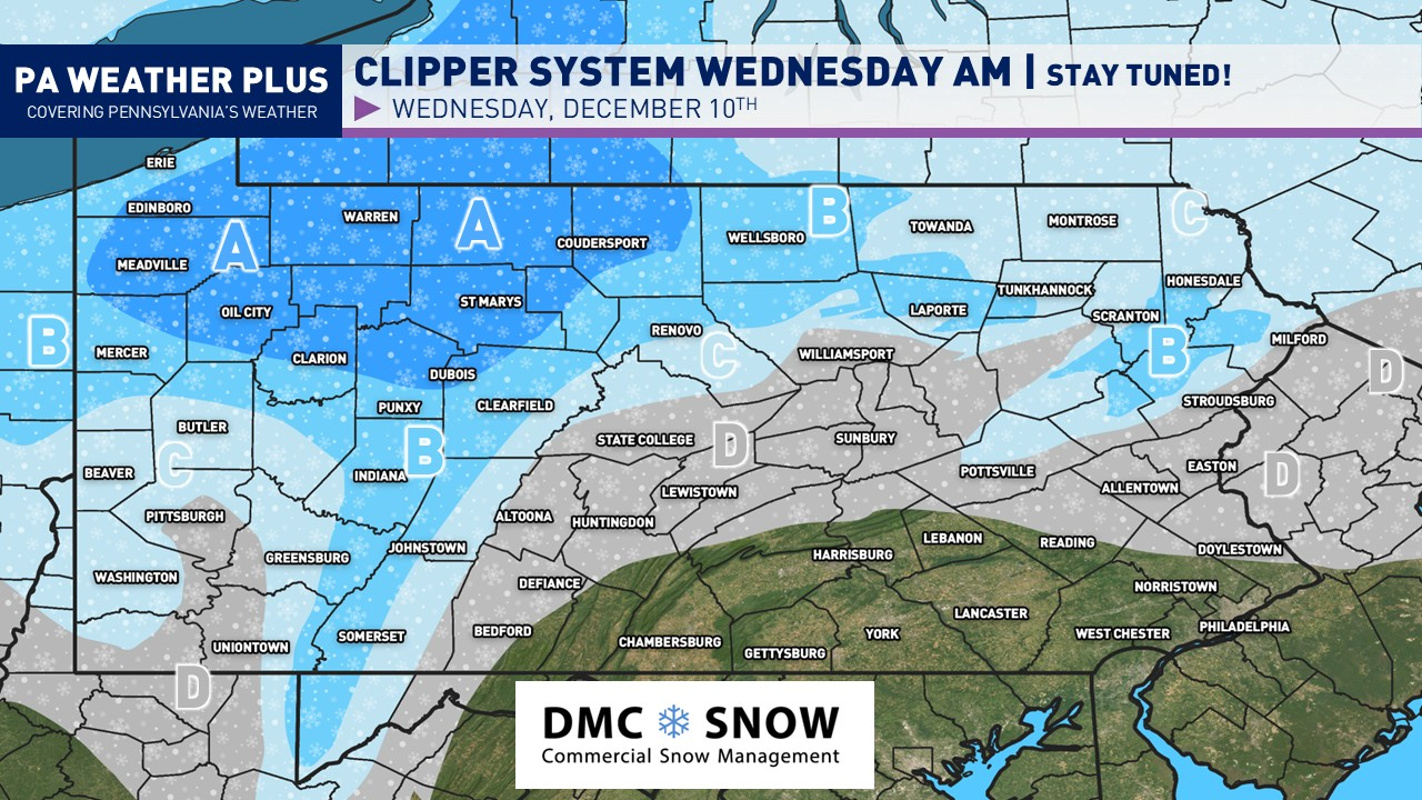
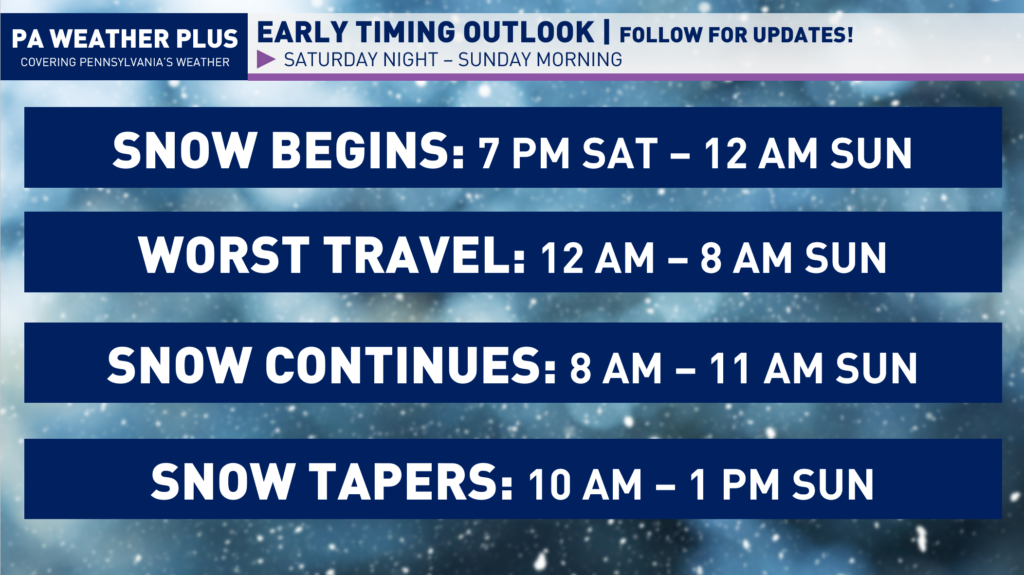
EARLY LOOK AT THE TIMING:
While a weaker versus stronger storm will have some differences in the timing, here is a general outline of when the snow arrives, the bulk of the storm, and when the storm is looking to exit. The worst of the travel will likely be overnight and into early Sunday morning, where the steadiest snow coincides with colder temperatures. The snow will begin to taper off Sunday morning and move out by early Sunday afternoon.
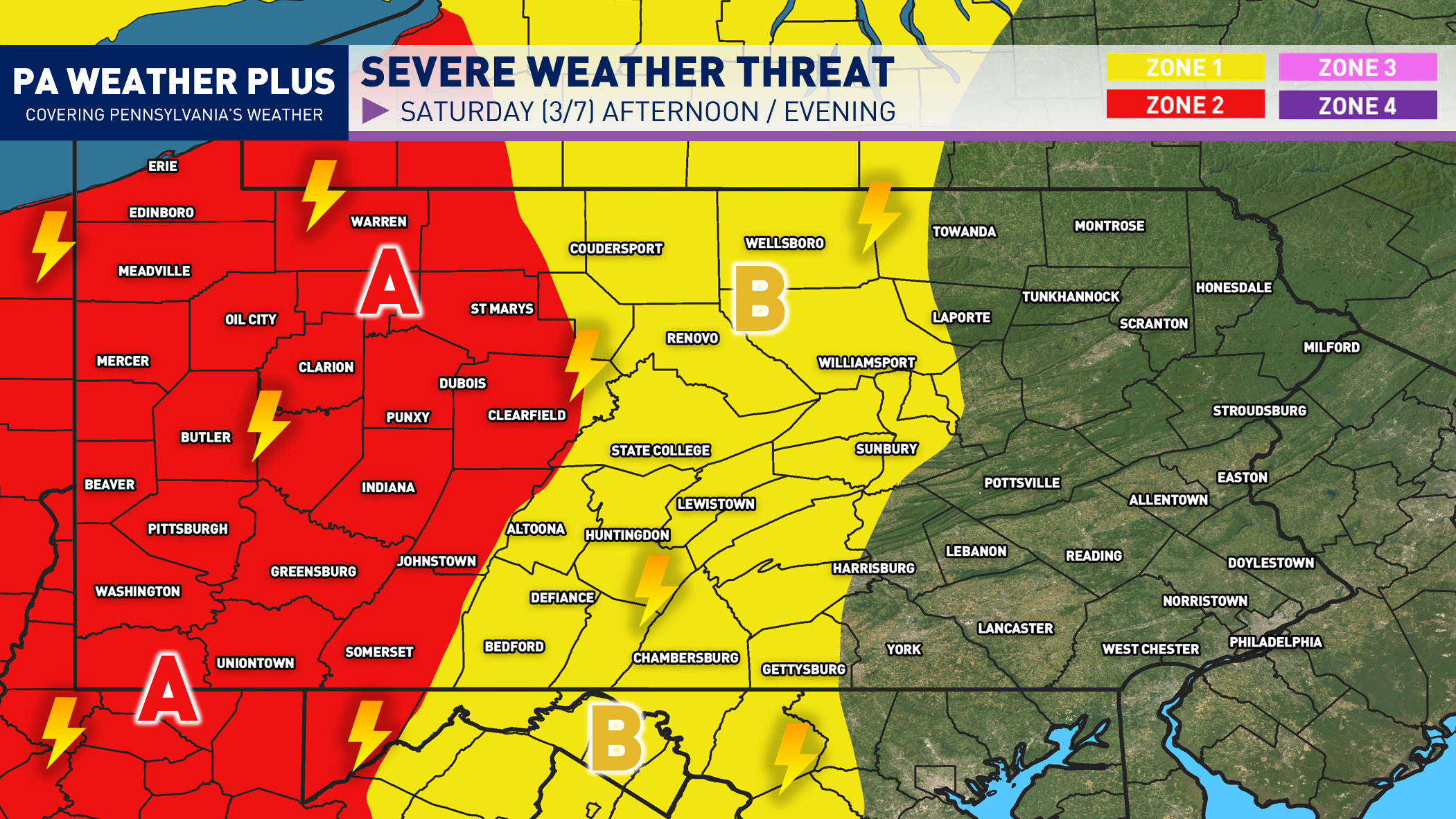
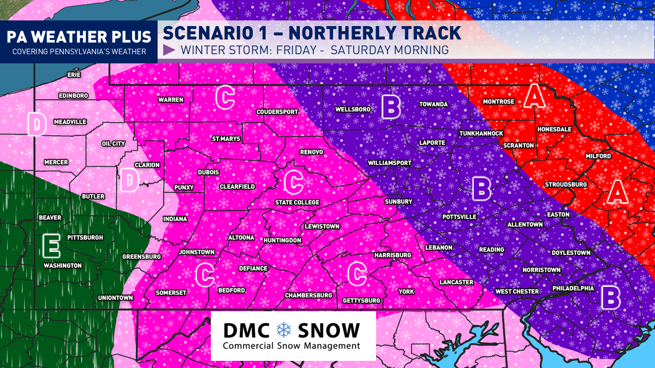
PENNSYLVANIA CURRENT SCENARIOS:
While these are not projected snowfall amounts, here is a generalized look at what each category refers to: Minor: At least flurries, Light: At least 1″, Moderate: At least 3″, Significant: At least 6″
SCENARIO 1: WEAKER/SOUTH 60%
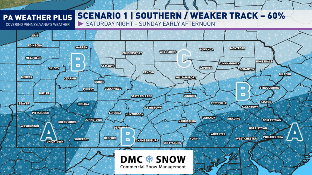
Over the past few model runs, there has been a consistent southern / weaker trend with our weekend storm system. This would suppress the highest snowfall amounts to the far two southern corners of the state.
AREA A: At least moderate snowfall accumulations would be expected. Most roadways and interstates will have issues with colder temperatures.
AREA B: Light snowfall accumulations would be expected. Some issues on roadways and interstates will be possible with colder temperatures.
AREA C: Minor snowfall accumulations would be expected. Likely to have no to minimal impacts.
SCENARIO 2: STRONGER/NORTH 40%
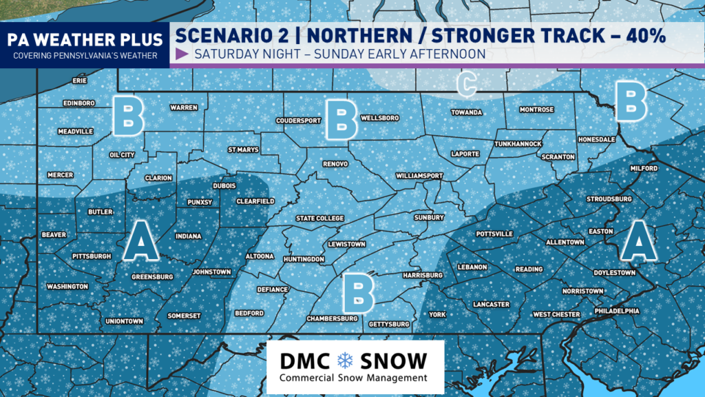
I am keeping the percentages on either side of 50% as there could be small atmospheric changes that will lead to large results in the size and impacts of the system.
AREA A: At least moderate snowfall accumulations would be expected. Most roadways and interstates will have issues with colder temperatures.
AREA B: Light snowfall accumulations would be expected. Some issues on roadways and interstates will be possible with colder temperatures.
AREA C: Minor snowfall accumulations would be expected. Likely to have no to minimal impacts.
It is highly recommended that you stay tuned to updates! Remember to disregard the hype you see online, as pages will post the snowiest model runs every 6 hours to try to scare you. I try to bring all of the facts, and I am leaning toward a weaker solution. While weak, this will still bring travel impacts with snow-covered roadways. Stay tuned for updates!
-Meteorologist Denys K.