We are now within 12 hours of impact from the first winter system of the season that will bring accumulating snow across much of Pennsylvania! Here is the final call snowfall forecast with the latest details. Without wasting your time, let’s jump straight into the details with expected timing and amounts!
Feel free to read the second call from earlier today: Second Call Pennsylvania Snowfall Forecast
JUMP TO THE FOLLOWING SECTION:
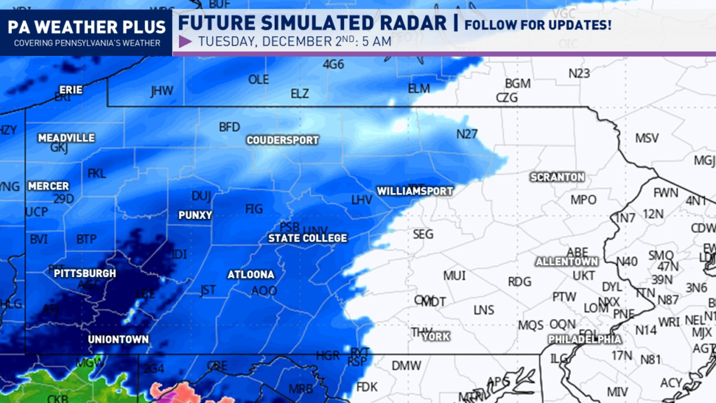
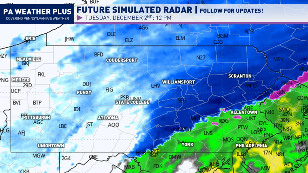
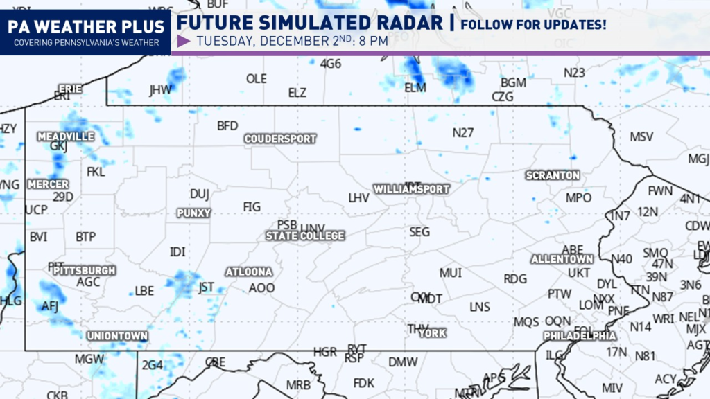
SIMULATED FUTURE RADAR:
In general, snow should only last between 8 – 14 hours at any given point. This system is in fast, and it is out fast! The fast track of the system will limit the higher-end snowfall amounts as we have no atmospheric blocking. If we had atmospheric blocking, this would have been a more significant winter storm, but we got lucky (or unlucky) this time around.
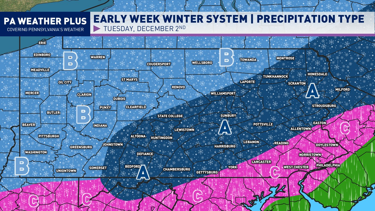
Snow will begin to overspread portions of the state by early Tuesday morning, with the steadiest snow occurring across western Pennsylvania. This is by 5 AM. Some of the snow across western PA will be moderate to possibly heavy.
By the mid-to-late morning and through the early afternoon is when the bulk of the storm will occur. The steadiest snow will occur across much of south-central through northeastern Pennsylvania. Snowfall rates of 0.50 – 0.75″ per hour will lead to reduced visibility and snow-covered roadways.

By the lunch hour, the bulk of the storm will begin to push eastward, with heavier snowfall rates across portions of south-central and northeastern Pennsylvania. The rain/snow line will also begin to creep up farther and farther north, limting snowfall impacts across southeastern Pennsylvania.
By the late afternoon and toward sunset, snow will continue to fall across much of eastern Pennsylvania, with snow showers beginning to wrap up across western and central Pennsylvania. There will still be snow-covered roadways due to decreasing sunlight and falling temperatures.
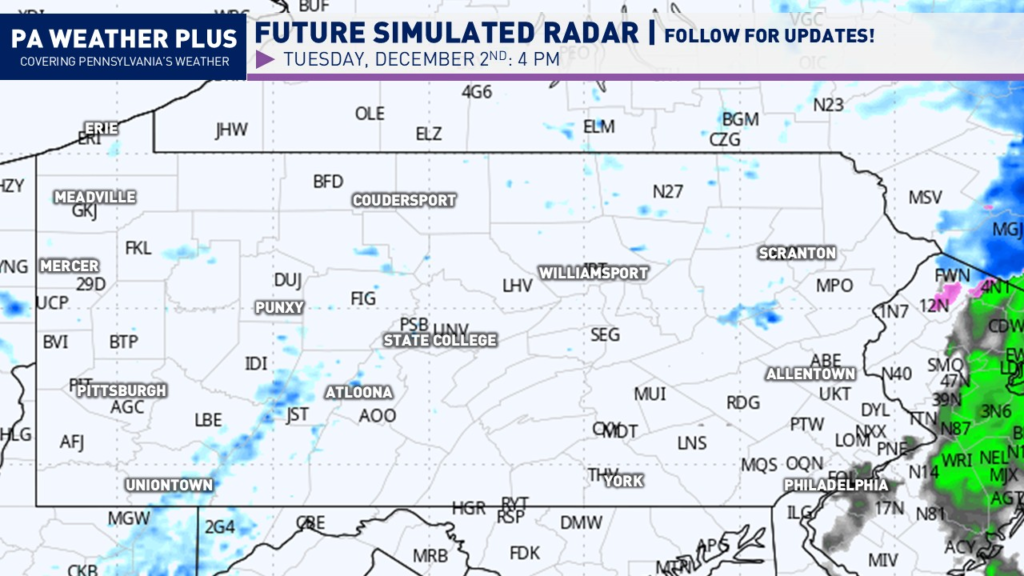
By the evening hours, much of the precipitation will have now exited with a few lake effect snow showers possible across far western Pennsylvania and perhaps some lingering minor action in far eastern PA. Although most will have mostly exited by now.
For a more defined timing specific to your location, check out: Your Local Weather
WINTER WEATHER ROAD CONDITIONS & TIMING:
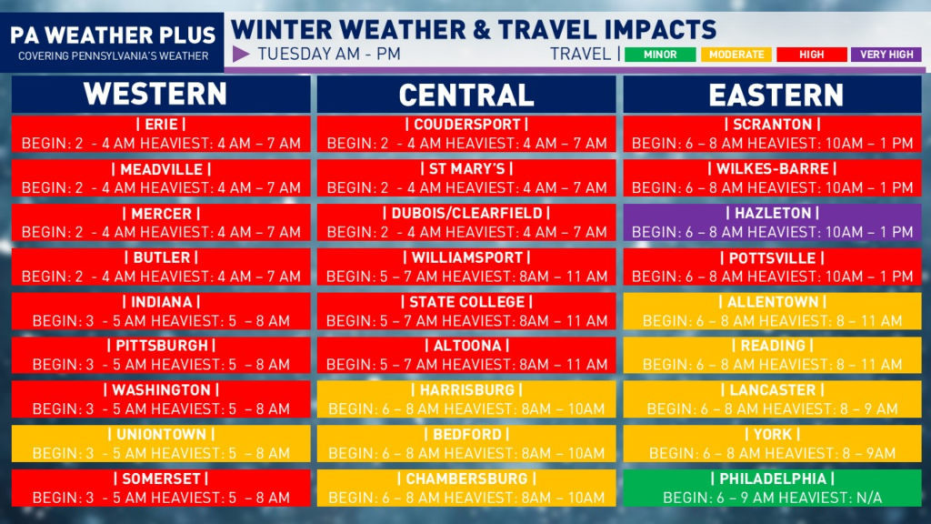
VERY HIGH: Almost all roadways including highways/interstates will be snow or ice-covered. You may become stranded on some routes. travel may be impossible at times. Travel is *HIGHLY* unrecommended.
HIGH: Most roadways and numerous highways/interstates will be snow or ice-covered. Be on alert for numerous accidents. Travel unrecommended.
MODERATE: Scattered roadways and a few highways/interstates may be snow or ice-covered. Be on alert for potential accidents. Lighter snowfall or ice events cause a higher percentage of accidents. Travel safely and reduce speeds.
MINOR: A few snow or ice-covered roadways will be possible. Be on alert for potential accidents. Lighter snowfall or ice events cause a higher percentage of accidents. Travel safely and reduce speeds.
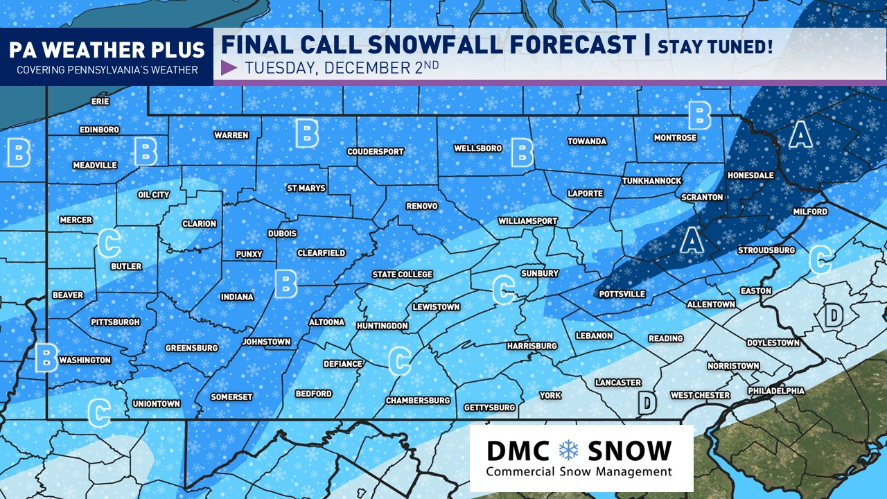
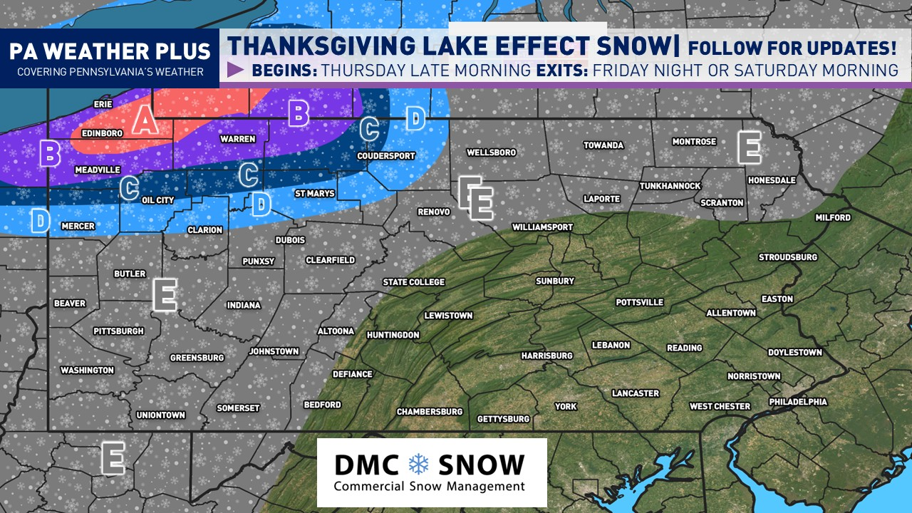
FINAL CALL SNOWFALL FORECAST:

AREA A: Significant amounts of 5 to 8 inches of snow expected. Expect potentially moderate to heavy snowfall rates. Snow-covered roads are likely, with business and school disruptions expected. I would highly recommend remaining off of roadways. Some towns/cities in this zone: Honesdale.
AREA B: Moderate snowfall amounts of 3 to 5 inches of snow expected. Expect potentially moderate to heavy snowfall rates, although shorter in duration compared to Area A. Snow-covered roads are likely with business and school disruptions expected. I would highly recommend remaining off of roadways. Some towns/cities in this zone: Erie, Coudersport, Pittsburgh, Wellsboro, Somerset
AREA C: Light snowfall amounts of 1 to 3 inches of snow expected. Overall, light snowfall rates are expected, but may become briefly moderate at times during the peak event. Snow-covered roads are possible with some business and school disruptions, primarily in the highest elevations. Interstates and well-treated roadways should be okay, but if you are planning to travel, please take it slow and use caution! Some towns/cities in this zone: Butler, State College, Chambersburg, Allentown, Easton
AREA D: Very light snowfall amounts of less than an inch of snow expected. Minimal travel disruptions may occur during the morning commute. Some towns/cities in this zone: Lancaster, Philadelphia, Doylestown
With it being the first widespread snow event for Pennsylvania, it is highly recommended that you stay tuned to updates! Remember to disregard the hype you see online, as pages will post the snowiest model runs every 6 hours to try to scare you. I try to bring all of the facts, and I am leaning toward a weaker solution. While weak, this will still bring travel impacts with snow-covered roadways. Stay tuned for updates!
-Meteorologist Denys K