Estimated reading time: 5 minutes
If you have felt that northwestern Pennsylvania has been stealing the snow as of late, you’re not wrong! The pattern has been favorable for lake effect winter storms, while the rest of the state receiving the short end of the stick with remnant snow showers and squalls. First the first time this season, a more widespread snow system is forecasted to impact the state. As we prepare for this upcoming snow event, there has been a lot of hype regarding this storm system, so let’s dig into all of the details and potential scenarios!
METEOROLOGICAL SET-UP:
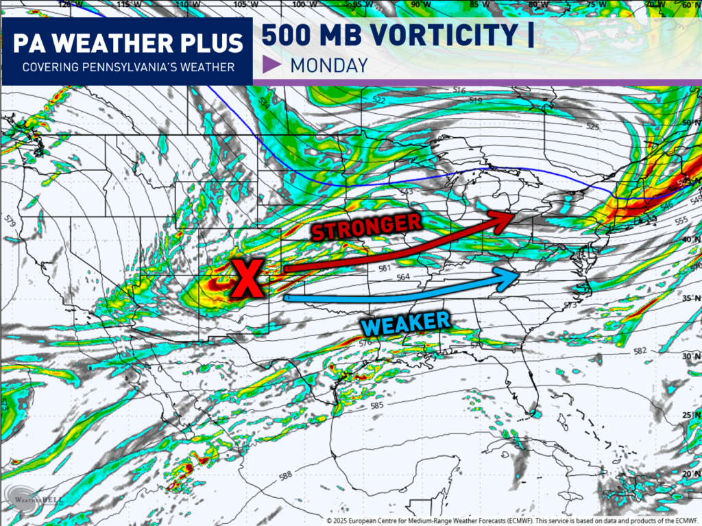
The 500mb layer of the atmosphere (18,000 feet above the ground) is one of the most important in regard to steering weather patterns. The 500mb level is high enough to be above local surface features (terrain, friction, local temperature variations) but low enough to stay connected to weather systems. Then, vorticity is just a fancy meteorology term that means spin in the atmosphere. More vorticity equals more spin which equals more disturbed weather and vice versa.
For this system, I am watching a bundle of vorticity that will be coming out of the southwestern United States on Monday, which will set up our storm on Tuesday. The stronger model solutions have this bundle of vorticity (or known as shortwave) on the northerly track, which allows for a stronger winter storm. On the other hand, the models that slide if farther south show a much weaker solution. While the northern/stronger snow event is not discounted, the current pattern favors the weaker/southern solution.
FIRST LOOK AT TIMING:
While a weaker versus stronger storm will have some differences in the timing, here is a general outline of when the snow arrives, the bulk of the storm, and when the storm is looking to exit.

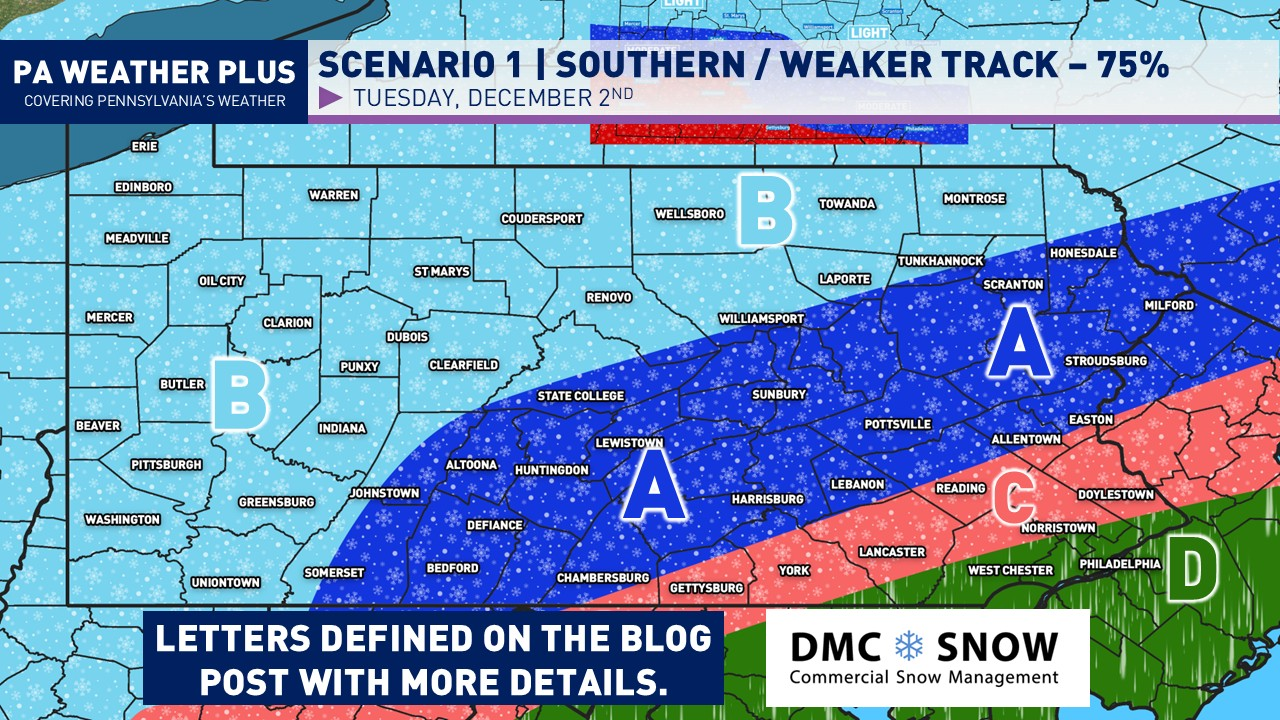
SCENARIO 1: WEAKER / IMPACTFUL
Given the current state of our pattern, I highly favor this scenario for our snow event, giving it a 75% chance of occurring. Now, while this scenario is more likely to occur, the final solution will still come down to the track / intensity of the system which could move any of these contours 10 – 25 miles in either direction.

AREA A: Moderate snowfall accumulations and likely to stay all snow. Some areas closer to the mixing zone may mix with sleet at times. Travel disruptions are likely on Tuesday with snow-covered roadways.
AREA B: Minimal to light snowfall accumulations and likely staying all snow. Areas of snow-covered roadways will be possible with some travel disruptions on Tuesday.
AREA C: Likely starting as a few hour period of snow, then changing to snow/sleet/rain, and finally changing to plain rain. Travel disruptions likely on Tuesday before the changeover to rain.
AREA D: Quick start with snow/sleet possible before changing to all rain. Travel disruptions highly unlikely.
SCENARIO 2: STRONGER / SIGNIFICANT:
Given the current pattern, it is highly unlikely that this scenario for our snow event will unfold. I put it at roughly 25% of verifying.

AREA A: Significant snowfall accumulations possible and likely to stay all snow. Widespread travel disruptions would be likely on Tuesday with snow-covered roadways.
AREA B: Moderate snowfall accumulations and likely to stay all snow. Some areas closer to the mixing zone may mix with sleet at times. Travel disruptions are likely on Tuesday with snow-covered roadways.
AREA C: Minimal to light snowfall accumulations and likely staying all snow. Areas of snow-covered roadways will be possible with some travel disruptions on Tuesday.
AREA D: Likely starting as a few hour period of snow, then changing to snow/sleet/rain, and finally changing to plain rain. Travel disruptions likely on Tuesday before the changeover to rain.
AREA E: Quick start with snow/sleet possible before changing to all rain. Travel disruptions highly unlikely.
With it being the first widespread snow event for Pennsylvania, it is highly recommended that you stay tuned to updates! Remember to disregard the hype you see online, as pages will post the snowiest model runs every 6 hours to try to scare you. I try to bring all of the facts, and I am leaning toward a weaker solution. While weak, this will still bring travel impacts with snow-covered roadways. Stay tuned for updates!
-Meteorologist Denys K.