Estimated reading time: 5 minutes
While we will not see a large-scale storm system impacting the region this Thanksgiving holiday, an incoming cold air mass will bring trouble. With warm Lake Erie lake temperatures, the lake effect snow machine will be turned on right in time for the holiday. Periods of heavy, accumulating snowfall are expected throughout the day on Thursday and Friday, leading to very treacherous travel conditions. Read below for all of the details!
READ THE FIRST CALL FROM YESTERDAY EVENING HERE: https://paweatherplus.com/thanksgiving-lake-effect-winter-snow-storm/
TIMING IT OUT:
This will be important to stay tuned to updates as the forecast evolves. Unfortunately, this is a higher confidence scenario, so it is unlikely that changes for the better will occur. The reason for that is that this cold air mass is guaranteed and the lake temperatures will not fluctuate, allowing for this lake effect winter storm to be forecast well in advance. Overall, since Sunday, the forecasted snowfallamounts continue to increase.
The snow will begin across northwestern Pennsylvania early-mid morning on Thursday. Snow will continue throughout the day, with the worst impacts beginning after sunset and through Friday morning. This is when we will lose the sunlight, and temperatures will drop into the 20s and low-30s. Treacherous travel will continue through Friday morning. Snow showers, at times heavy, will continue throughout the remainder of the day on Friday. The showers will begin to taper off by late Friday into very early Saturday morning.

WINTER WEATHER ALERTS:
As of Tuesday evening, Lake Effect Snow Warnings have been issued for McKean, Warren, and Erie Counties. A Winter Storm Watch remains in effect for Crawford County. These alert counties will see the most significant impacts with treacherous road travel. Keep in mind, depending on when you view this post, watches may have expanded and/or other alerts may have been posted. Check with weather.gov for your latest alert information.

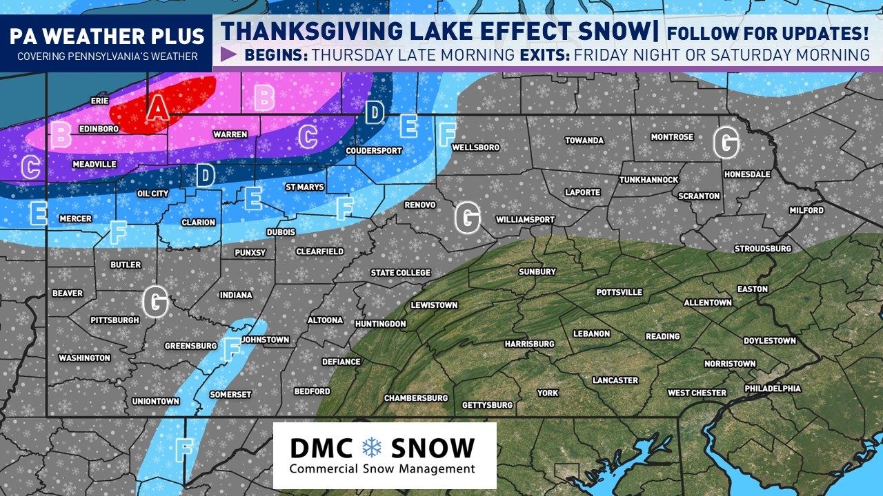
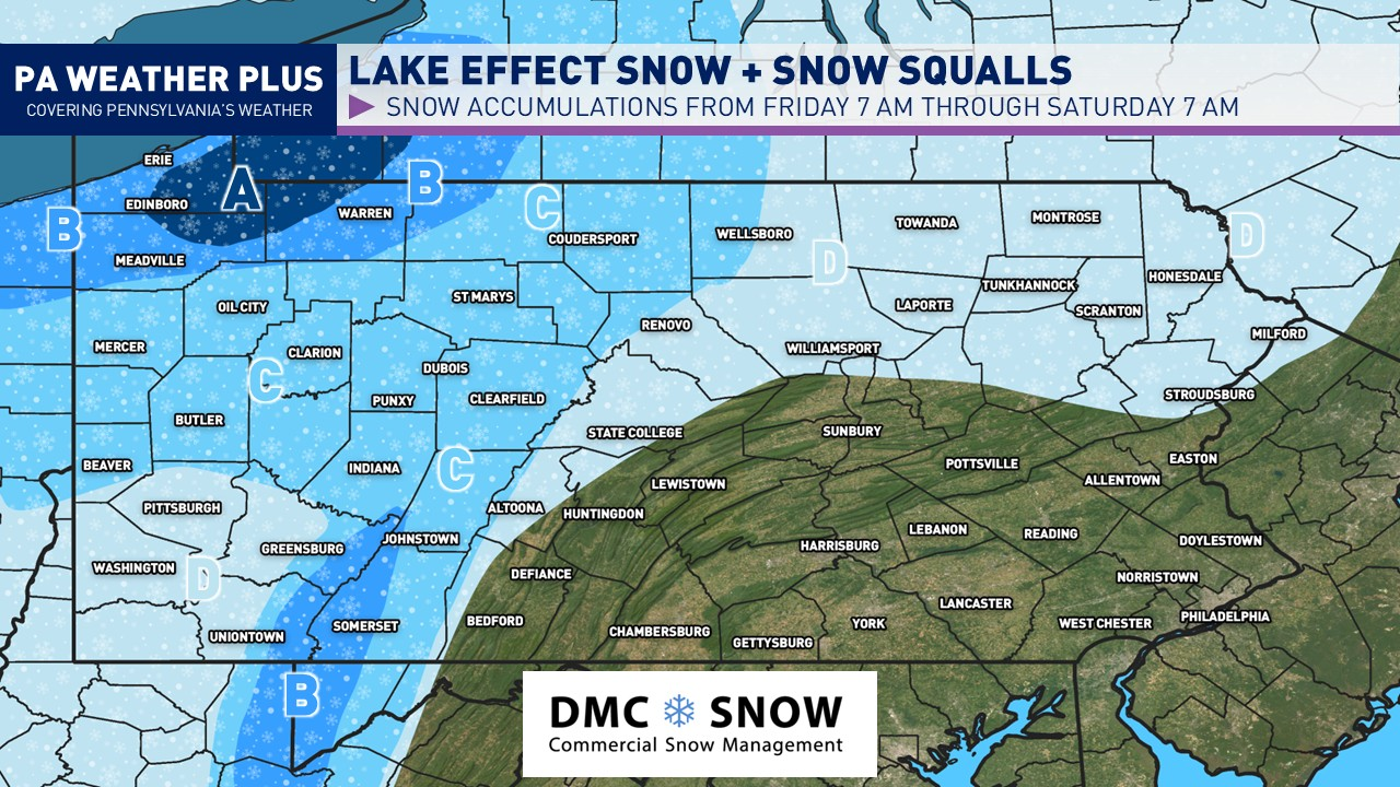
SECOND CALL SNOWFALL AMOUNTS AND IMPACTS:

HEAVY SNOW AND WIND ALERT: Areas A – C will see wind gusts of 35 – 45 mph throughout the snow event. This will allow for blowing snow, reducing the visibility even more. Travel is highly unrecommended once conditions begin to worsen throughout the day on Thursday.
AREA A: Greatest area of confidence for 16 to 22 inches. Snowfall rates will exceed 1-2″/hr in the heaviest bands. Expect treacherous travel Thursday afternoon through Friday late morning with snow-covered roadways and very limited visibility with heavy snowfall. This includes the higher terrain of Erie, Warren and Crawford Counties. I would avoid travel in this area once conditions begin to worsen.
AREA B: Heavy lake effect snow expected. 12 to 16 inches expected with isolated higher amounts. Snowfall rates will exceed 1-2″/hr in the heaviest bands. Expect treacherous travel Thursday afternoon through Friday late morning with snow-covered roadways and very limited visibility with heavy snowfall. I would avoid travel in this area once conditions begin to worsen.
AREA C: Heavy lake effect snow expected. 8 to 12 inches of snow expected with isolated higher amounts. Snowfall rates will exceed 1-2″/hr in the heaviest bands. Expect treacherous travel Thursday afternoon through Friday late morning with snow-covered roadways and very limited visibility with heavy snowfall. Expect snow-covered roadways, especially Thursday evening through early Friday morning. I would avoid travel in this area once conditions begin to worsen.
AREA D: Outer bands of the heaviest lake effect snowfall. 5 to 8 inches of snow expected with isolated higher amounts. Snowfall rates may exceed 1″/hr at spotty times. Expect snow-covered roadways, especially Thursday evening through early Friday morning.
AREA E: Far outer bands of the heaviest lake effect snowfall with snow showers and squalls. A general 3 to 5 inches of snow is possible with localized higher amounts. Expect snow-covered roadways in any heavier snow shower or snow squall Thursday evening through early Friday morning.
AREA F: Lake effect snow showers and snow squalls. A general 1 to 3 inches of snow is possible. Expect snow-covered roadways in any heavier snow shower or snow squall Thursday evening through early Friday morning.
AREA G: Areas of snow showers expected late Thursday night, throughout Friday morning and early afternoon. Minimal accumulations of a dusting expected with an isolated half inch in any heavier snow shower or squall. Just be mindful of possible slick spots on roadways, especially in those areas that may see a steadier snow shower.
With the Thanksgiving holiday, it is a good idea to remain cautious of this snowfall event. Keep in mind, with lake effect winter storms, travel conditions may go from “great” to “impossible” in as little as 10 – 15 minutes as lake bands pivot with changing wind directions. It is likely post sunset on Thursday through Friday morning that we will see snow-covered roadways with very low visibility in Area A & B. If you are able to travel on Wednesday and/or Saturday, I would highly recommend in these areas. In the other areas, just practice caution and judge it the day of with how conditions may be.
I will provide more updates over the next few days. Stay tuned and stay safe!
-Meteorologist Denys K.