Estimated reading time: 5 minutes
A low-pressure system will pass to our north, although we will see the impacts from a strong cold front that will be attached to it. As this passes through the region tomorrow afternoon and evening, high wind gusts will occur. These higher wind gusts may cause concern for power outages across Pennsylvania. After the front moves through, we will see *much* colder air on Thursday, which will allow for rain mixed with snow showers. Read below for all of the details! If you have any questions and/or concerns, reach out!
JUMP TO THE FOLLOWING:
ATMOSPHERIC SETUP:

A strengthening low-pressure system across New York state will bring down a strong cold front through Pennsylvania. Higher pressure is to the south. There will be a strong pressure gradient force (look at the distance between the black solid lines) as the low pressure ‘battles’ the higher pressure. This pressure gradient force will increase the high wind risk. Over the past 24 hours, we’ve observed an increase in the low-pressure strength. This change will only increase our high wind potential.

Ahead of the cold front, with strong southerly flow, it will warm up quite nicely! Many areas will climb into the low-to-mid 60s across Pennsylvania. Find some time to enjoy the milder conditions before the cold front moves through. High temperatures on Thursday will only climb into the mid-40s to low-50s.
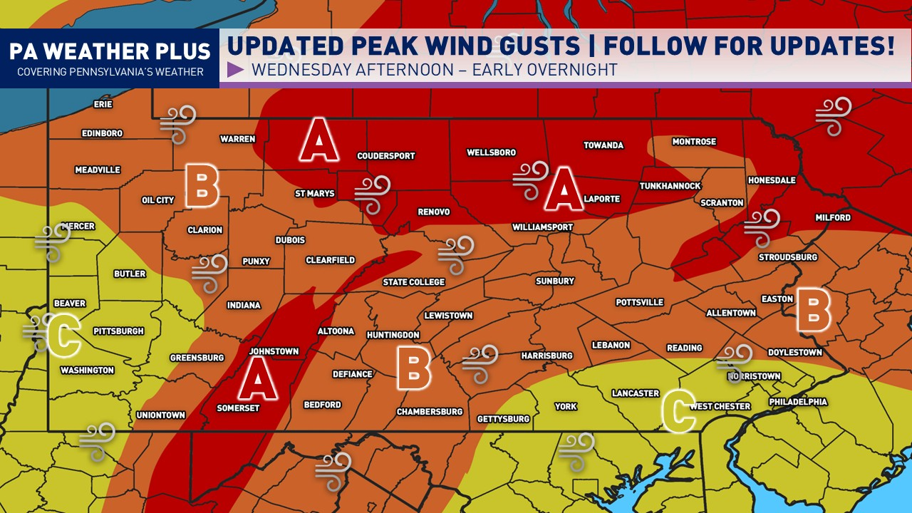
PENNSYLVANIA PEAK WIND ONSET

Here is when the highest wind gusts will move through late Wednesday afternoon and evening. It will be breezy ahead of the cold front, with wind gusts of 20 to 35 mph. Then, the highest gusts will occur along a squall line that will progress through the state west-to-east. The wind gusts will stay elevated for roughly 1-2 hours. They will diminish slowly throughout the night after the front passes through.
PENNSYLVANIA WIND GUST FORECAST & IMPACTS

ZONE A: Peak wind gusts 50 – 60 MPH. A few gusts over 60 MPH are not ruled out. Damaging wind gusts could blow down trees and power lines. This may result in widespread power outages. High winds may make travel difficult, especially in high-profile vehicles. Non-secured objects and trash cans will be blown away.
ZONE B: Peak wind gusts 40 – 50 MPH. A few gusts over 50 MPH are not ruled out. Higher wind gusts may result in a few downed trees and power lines. This may result in isolated to scattered power outages. Non-secured objects may be blown around.
ZONE C: Peak wind gusts 30 – 40 MPH. A few gusts over 40 MPH are not ruled out. Issues are generally not expected, although brief higher gusts may down a tree or two. Power outages are not expected but may occur in an isolated instance.
PENNSYLVANIA SNOW FORECAST

Behind the cold front and low-pressure system, we will have much cooler air filter into Pennsylvania. With some remnant moisture and additional help from the Great Lakes, a few rain showers will mix with snowflakes, primarily in northern and northwest Pennsylvania. Elevations greater than 1700 feet will be most favored.
AREA A: A few snow showers mixed with rain showers are expected 3 – 11 AM Thursday morning. Snow accumulations are not expected; however, a quick coating in a heavier burst may occur on elevated surfaces.
QUICK SUMMARY
- A strong cold front will pass through Pennsylvania, causing high wind gusts and potential power outages.
- Wind gusts will peak between 50-60 MPH in Zone A, 40-50 MPH in Zone B, and 30-40 MPH in Zone C, leading to scattered impacts.
- Expect much colder temperatures on Thursday with rain mixed with snow showers, especially in northern Pennsylvania.
- Areas above 1700 feet may see a dusting of snow on elevated surfaces
- Stay updated by following us on Facebook for the latest weather information.
FOR MORE UPDATES, FOLLOW US ON FACEBOOK!
Share below to spread this weather update to your family, friends, etc, to keep them weather aware!
-Meteorologist Denys Khrulov