Here is a quick morning update regarding the upcoming coastal storm / Nor’easter that will impact Pennsylvania beginning late tonight into Sunday morning. As our coastal storm begins to phase with an upper-level low over the Great Lakes region, it will grow in size and bring gusty winds and rain into much of central and eastern Pennsylvania.
WHAT CHANGED SINCE THURSAY? The ‘phase’ is a little bit sloppier than what was once agreed upon 24-48 hours ago. This overall leads to a ‘weaker’ Nor’easter storm, but my forecast has not changed a whole lot since Thursday, and the bigger picture still stands. The steadiest rains and highest wind gusts will be the farther east you are located. And yes, 40 mph wind gusts over extended periods of time can and will lead to some tree damage and power outages due to fully leafed trees and dry soils. This is different from a winter wind event, where neither of those is true.
JUMP TO THE FOLLOWING:
FUTURE SIMULATED RADAR:
Disclaimer: Keep in mind, these are simulated radar projections using high-res modeling and may not be exactly 1:1 to what occurs Sunday through Monday night.
The forecast for Sunday morning and early afternoon has trendend largely drier. Majority of the rain showers will be focused into New Jersey. A few isolated showers could be possible across Pittsburgh.

By the late afternoon hours, showers will begin to move into the state, especially across south-central and southeastern Pennsylvania. A coastal Nor’easter is producing some of these showers, which will be steadier in intensity and produce gusty winds.

Showers will continue overnight across much of central and eastern Pennsylvania, steady at times. The scattered activity will continue into Monday morning, making for a soggy start to the week.

The rain will continue through Monday morning and linger into early Monday afternoon. The best chance will be across the central and eastern portions of the state.

By Monday evening, we will continue to have a few lingering rain showers as the Nor’easter begins to pull away from the coastline and begin to head out to sea. These showers will linger into the middle of the night on Monday before fully leaving Pennsylvania with dry conditions by Tuesday morning.

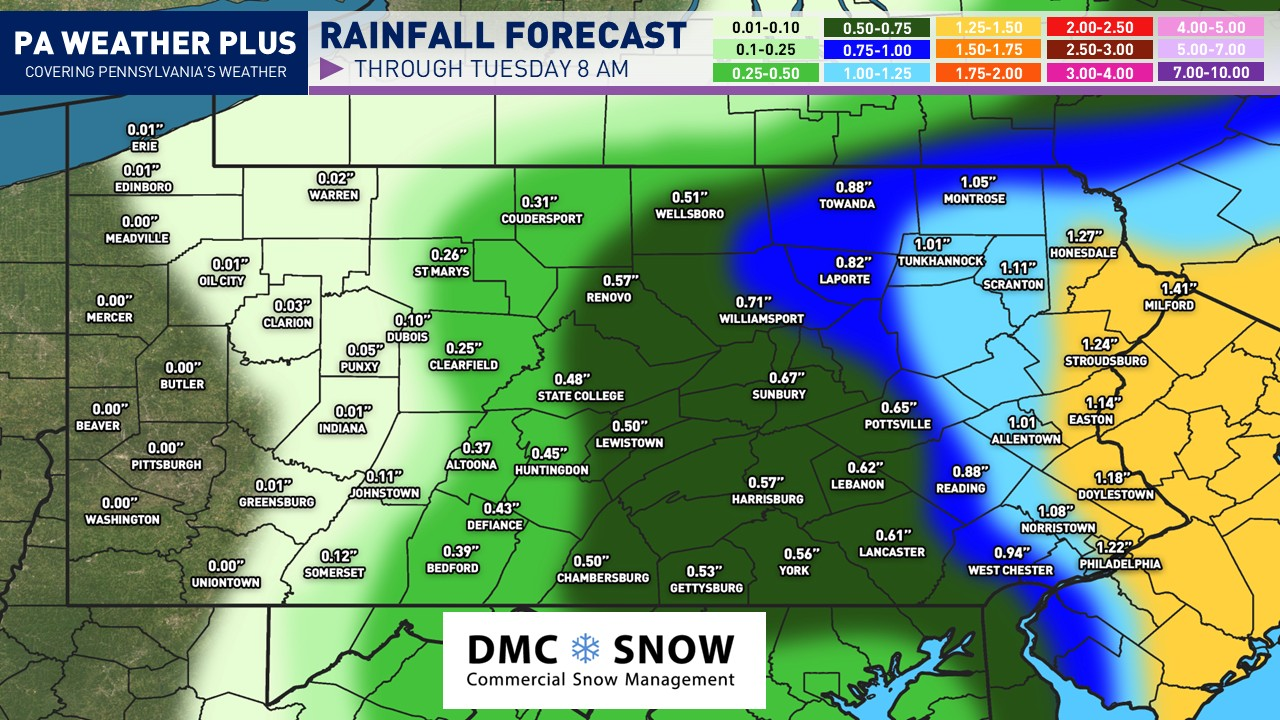
RAINFALL FORECAST:

This rain will fall between tonight and all the way through TUESDAY MORNING with this Nor’easter. There will be periods of steadier rain across central and eastern Pennsylvania, but it will NOT all fall tomorrow.
The majority looks to now fall Sunday evening through Monday afternoon, before slowly dissipating west-to-east Monday night into Tuesday morning. Much of central Pennsylvania will see between 0.25-0.75″ of rainfall, with greater than an inch expected across eastern Pennsylvania.
The rainfall accumulations will come in multiple waves and WILL NOT all fall tomorrow. I will continue to update the rainfall map throughout the forecast period to continue to show you additional accumulations on Facebook, Instagram, and X.
UPDATED PEAK WIND GUST FORECAST:
The highest wind gusts will occur late Sunday night through Monday morning with this Nor’easter. Gustier winds will linger throughout the rest of the day on Monday, but likely under the peak intensity.

AREA A: Wind gusts up to 50-55 mph. Areas of downed trees and power outages are expected.
AREA B: Wind gusts up to 40-45 mph. Isolated downed trees and power outages are expected
AREA C: Wind gusts up to 30-35 mph. Limited down trees and power outages are expected.
AREA D: Wind gusts up to 20-25 mph. Downed trees and power outages are generally not expected.
For a more in-depth forecast based on your location, please visit https://paweatherplus.com/your-local-weather/. This page was created with NWS/NOAA data and will give you a more in-depth forecast!
Main Takeaways
- A coastal storm/Nor’easter will impact Pennsylvania starting tonight through Monday night, bringing gusty winds and rain.
- The storm has weakened slightly since Thursday, but heavy rain and wind gusts up to 40 mph are still expected, leading to potential tree damage and power outages.
- Steady showers will begin in the afternoon, continuing overnight and into Monday morning, especially in central and eastern Pennsylvania.
- Rainfall totals will range from 0.25-0.75 inches in central PA, with over an inch possible in eastern PA, occurring in multiple waves.
- Peak wind gusts will occur late Sunday night into Monday morning, with gusts up to 40 – 45 mph in some areas causing isolated power outages.
FOR MORE UPDATES, FOLLOW US ON FACEBOOK!
Share below to spread this weather update to your family, friends, etc, to keep them weather aware!
-Meteorologist Denys Khrulov