Estimated reading time: 6 minutes
10/11 UPDATE: A new rainfall and wind map has been posted to my Facebook page ‘ PA Weather Plus, LLC’. I will try to publish a new blog post later today time-pending. Thank you for the support and understanding! FACEBOOK PAGE: https://www.facebook.com/paweatherplus/
After many weekends of drier weather, we are switching it up for the second weekend of October. A coastal storm, akin to a Nor’Easter, will impact much of the Commonwealth of Pennsylvania with gusty winds and heavier rains. Showers will begin to develop across the state on Saturday, with the main event beginning on Sunday afternoon. Impacts will linger through Monday. Let’s jump into the details!
Table of contents
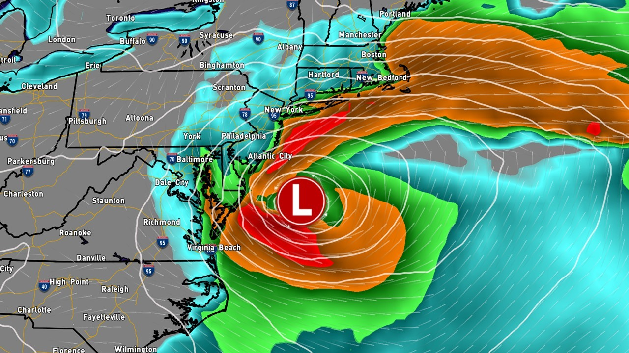
FUTURE SIMULATED RADAR:
Disclaimer: Keep in mind, these are simulated radar projections using low-res modeling and may not be exactly 1:1 to what occurs Saturday through Monday.
While the majority of Saturday will be dry, showers will begin to fire across the state after 5:00 PM. Especially after 8:00 PM across portions of northwest through south-central Pennsylvania. These showers should overall be hit-and-miss, but be prepared to see some raindrops during this Nor’Easter!

The main coastal storm will begin to take shape Sunday morning. Widespread light to moderate rain showers will begin to spread across the state. It should not be as widespread as simulated here, but there will be more showers around compared to Saturday evening.

By Sunday afternoon, as our coastal storm begins to strengthen, we will see steadier light to moderate rains begin to spread across central and much of eastern Pennsylvania. This shield of rain will slowly spread from southeast to northwest throughout Sunday, typical for a Nor’Easter.

By Sunday evening, rain will continue to impact much of central and eastern Pennsylvania. There may be some dry slots within the rain shield of the Nor’Easter, which may lessen the intensity of the rainfall at times.

Showers will continue to hang around into Monday morning as our coastal storm begins to slowly stall out before beginning to head out to sea. These showers will stick around much of central and eastern Pennsylvania for most of the day on Monday. These rain showers should come in intervals and slowly lessen in intensity throughout the afternoon.

For a more localized precipitation forecast with detailed hour-by-hour timing, check out the following page on our website throughout the weekend: Your Local Weather
GUSTY WINDS / POWER OUTAGES:
STRONG WIND GUSTS WILL LEAD TO SPORADIC TREE DAMAGE / POWER OUTAGES ACROSS EASTERN PENNSYLVANIA... Do not just focus on the rainfall amounts from this storm system. Prolonged elevated wind gusts may help to bring a few trees down throughout Sunday night, which will lead to power outages. If you are prone to losing power, keep this in mind and make sure you prepare ahead of the highest wind gusts Sunday evening and overnight!
HIGHEST WIND GUSTS ANTICIPATED: 2 PM Sunday – 2 PM Monday

ZONE A: Wind gusts up to 50 mph. Scattered downed trees and power outages are expected. These gusts may increase if the coastal storm trends westward.
ZONE B: Wind gusts up to 40 mph. Isolated downed trees and power outages are expected. These gusts may increase if the coastal storm trends westward.
ZONE C: Wind gusts up to 30 mph. Limited down trees and power outages are expected.
ZONE E: Wind gusts up to 20 mph. Downed trees and power outages are generally not expected.
UPDATED RAINFALL AMOUNTS:
I will not get uber specific into the totals, as this will be dependent on the track of the coastal low. If this coastal low trends farther east and more inland, this will *increase* rainfall amounts across central and eastern Pennsylvania. Flooding issues may arise due to the very dry ground, so a lot of the rain will be running off, but more updates regarding the flooding threat will come over the next 36 hours.

AREA A: 2 to 3 inches of rain currently expected, with isolated higher amounts not ruled out. Minor flooding concerns not ruled out.
AREA B: 1 to 2 inches of rain currently expected. Low-lying and flood-prone areas may see ponding, but flooding is not generally expected.
AREA C: Up to 1 inch of rain is currently expected. Flooding is not expected.
AREA D: – Less than 1 inch of rain is currently expected, but expect at least a quarter of an inch. Flooding is not expected.
Key Takeaways
- A coastal storm, similar to a Nor’easter, will impact Pennsylvania this weekend with gusty winds and heavy rain.
- Showers begin Saturday evening, becoming steadier on Sunday, especially across central and eastern Pennsylvania.
- Expect strong wind gusts up to 50 mph in Zone A, potentially causing tree damage and power outages.
- Rainfall amounts may vary; up to 2 to 3 inches in some areas may lead to minor flooding concerns.
- Continuously check updates for localized precipitation forecasts and potential flooding threats.
FOR MORE UPDATES, FOLLOW US ON FACEBOOK!
Share below to spread this weather update to your family, friends, etc, to keep them weather aware!
-Meteorologist Denys Khrulov