Estimated reading time: 4 minutes
After 10+ days of no widespread rainfall across Pennsylvania, we have finally some beneficial rainfall lined up to move across the state. A cold front will help to spawn showers and t-storms Tuesday afternoon across western Pennsylvania Tuesday afternoon before more widespread rains move eastward on Wednesday. After the cold front moves through, we are set for more seasonable October air!
FUTURE SIMULATED RADAR
By lunch hour on Tuesday, showers will begin to move into western Pennsylvania. Cities such as Pittsburgh and Erie will start to see some of these impacts. Isolated showers could move farther east, but it would take time to reach the ground with some drier air near the surface.

By the middle of the afternoon, showers and isolated thunderstorms will continue to impact western and central Pennsylvania. Pittsburgh, State College, and Altoona all look to be wet by this hour.

By the evening hour and post-sunset, showers and thunderstorms will continue to impact much of western Pennsylvania. Isolated to hit-and-miss showers or a storm will impact central and eastern Pennsylvania.

By the overnight hours, the most widespread rain will impact Pennsylvania. Given the latest radar simulation, showers and thunderstorms will impact Pittsburgh, State College, Altoona, and Johnstown. Some of these will begin to move into Scranton and Harrisburg.

Showers and rumbles of thunder will then quickly end across the state west-to-east throughout the Wednesday morning commutee. By Wednesday afternoon, much cooler air will infiltrate, allowing for seasonable October air.
For a more localized precipitation forecast with detailed hour-by-hour timing, check out the following page on our website: Your Local Weather
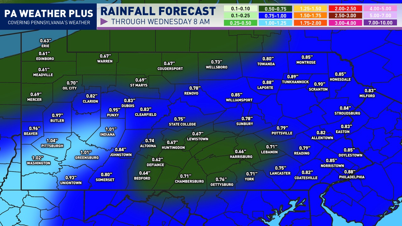
PROJECTED RAINFALL AMOUNTS:

We are looking at a decent rain storm across Pennsylvania! Most towns and cities will pick up at least a half-inch of rainfall, with portions of southwestern Pennsylvania forecasted to pick up upwards of an inch. Areas across eastern Pennsylvania could see upwards of an inch of rainfall as well, including Philadelphia and Scranton. This will help to subtract from our ongoing drought!
KEEP IN MIND: What you see here may vary by a degree. If you are impacted by a heavier shower/thunderstorm, you may see more than forecasted, and if you are in a dry slot and/or miss out on the heavier showers/storms, you may see less than forecasted.
TEMPERATURE DROP:
High temperatures on Thursday will be seasonable for early October, with many locations climbing into the upper-50s to low-60s. Are you excited for the seasonal rush of air?

Key Takeaways:
- Pennsylvania will finally see beneficial rainfall after over 10 days of dryness, starting Tuesday afternoon with a cold front.
- Showers and thunderstorms will impact western and central Pennsylvania, reaching cities like Pittsburgh and State College by afternoon.
- Widespread rain will affect the state overnight into Wednesday morning, with rainfall expected to help address ongoing drought conditions.
- Projected rainfall amounts range from half an inch to over an inch in various areas, especially in southwestern and eastern Pennsylvania.
- For localized forecasts and updates, visit the Your Local Weather page on our website.
FOR MORE UPDATES, FOLLOW US ON FACEBOOK!
Share below to spread this weather update to your family, friends, etc, to keep them weather aware!
-Meteorologist Denys Khrulov