Estimated reading time: 3 minutes
It has been quite the rainy week thus far, and more is on the way across the state of Pennsylvania. Another low-pressure system is slated to move through the region, helping to spark off additional showers and thunderstorms throughout the day on Thursday. Here is your Pennsylvania Rainy Weather Update!
Jump to the following:
ESTIMATED PRECIPITATION LAST 5 DAYS
While portions of the state have benefited from the rainfall, some other areas have not been as lucky. Much of the heaviest rainfall has occurred across western Pennsylvania, with more gaps in precipitation across eastern Pennsylvania. Tomorrow’s rain potential will hopefully fill in these gaps of much-needed rainfall.

FUTURE SIMULATED RADAR
Disclaimer: Keep in mind, these are simulated radar projections using high-res modeling and may not be exactly 1:1 to what occurs throughout the day on Thursday but is a great representation.
Feel free to pause at certain hours throughout the video to get a better representation.
The morning hours will be filled with rain showers and thunderstorms. As we progress throughout the late morning and into the early afternoon, the rain will begin to progress farther eastward. Additional thunderstorm development is expected across eastern Pennsylvania during the afternoon/evening hours. Some of these thunderstorms can be on the stronger side and produce damaging winds and an isolated weak tornado. Nevertheless, if you are planning to be outdoors, it will be good to have your umbrella!
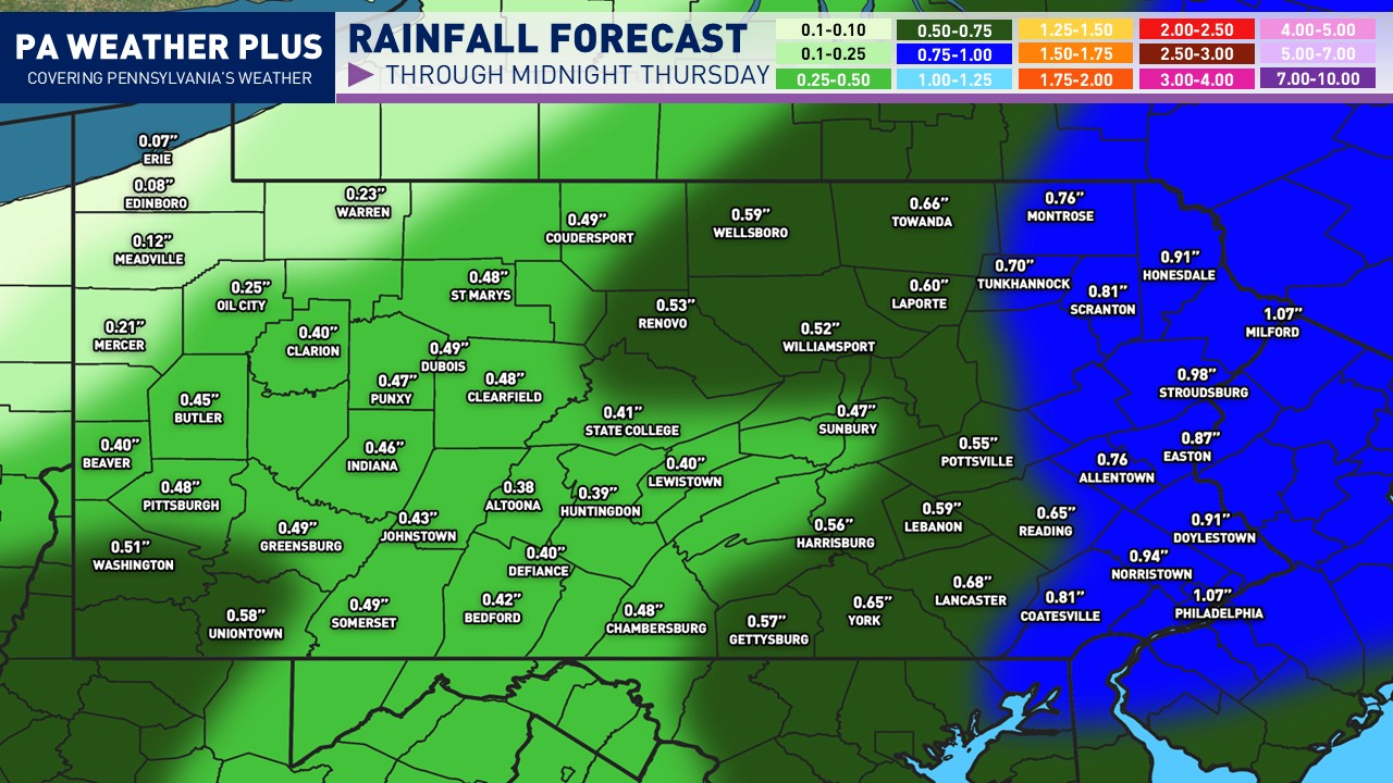
PRELIMINARY RAINFALL AMOUNTS:

Another great soaking is on the way tomorrow, with the best chance for higher precipitation amounts across eastern Pennsylvania. This is where we will see the more widespread and heavier thunderstorms, which could add up to higher rainfall totals. Flash flooding is not anticipated, but any heavier storm could cause a localized flooding risk, especially in low-lying and more flood-prone areas.
KEEP IN MIND: What you see here may vary by a degree. If you are impacted by a heavier shower/thunderstorm, you may see more than forecasted, and if you are in a dry slot and/or miss out on the heavier showers/storms, you may see less than forecasted.
SEVERE WEATHER FORECAST:

Area A: Isolated storms may produce 40 – 55 mph, and an isolated spin-up tornado not ruled out.
Larger Pennsylvania cities/towns at risk: Stroudsburg, Allentown, Easton, Harrisburg, York, Reading, Philadelphia
What “isolated” means: Most spots miss out, but one or two strong storms are possible anywhere within the zone. In this zone, it is better to remain aware, especially if planning to be outdoors for prolonged periods of time.
FOR MORE UPDATES, FOLLOW US ON FACEBOOK!
Share below to spread this weather update to your family, friends, etc, to keep them weather aware!
-Meteorologist Denys K.