

We’ve made the drastic corner from a cold and snowy winter to an active start to the severe weather season. What’s baffling is that it is still technically winter as the spring equinox does not occur until Friday, March 20th. This is the 3rd severe weather risk in the last 10 days, and this one has the one to bring the greatest potential for damaging wind gusts and possible weak tornadoes.
CLICK TO JUMP TO THE FOLLOWING:
FUTURE SIMULATED RADAR:
Keep in mind, this is a radar simulation and may vary from what actually occurs. This is just a way to see the bigger picture of what may occur. A detailed “best timing” for towns/cities across the state is listed below!
Late Morning / Early Afternoon: Showers and some thunderstorms will begin to fire across far western Pennsylvania. This is the best chance across western PA.
Mid-to-Late Afternoon: This will be the ‘peak’ timing for the strongest storms due to the overlap of the warmest temperatures and humidity. These will be moving through central and portions of eastern Pennsylvania at this time. Any storm that develops ahead of the squall line may become supercellular and have a greater risk of producing an isolated tornado.
Late Afternoon to Early Evening: As the storms move into far eastern Pennsylvania, they may slightly weaken. Rain begins to change over to periods of snow on the backside across much of central Pennsylvania. As of right now, minor accumulations of less than one inch are expected with the potential snowfall risk.
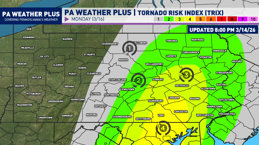
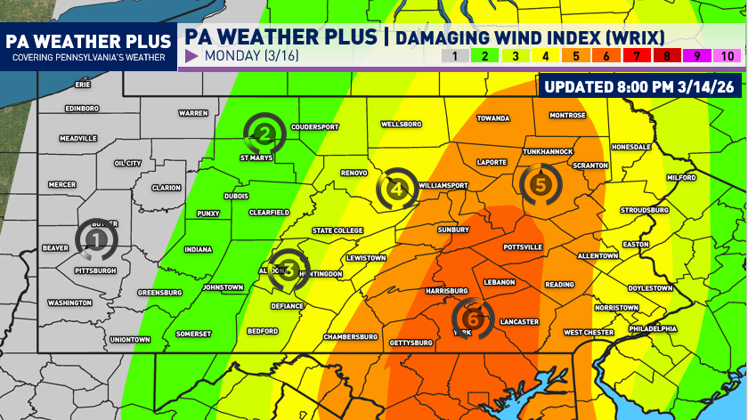
NEW TORNADO RISK / DAMAGING WIND RISK SCALES:
Introducing a new way to visualize the severe weather risk(s)… the TRIX (tornado) and WRIX (wind) scales! These are going to be scales ranging from 1 to 10, indicating the risk for either a tornado or damaging wind gusts (>58 MPH). While the normal scale of Zones 1 through 4 will continue to be used, these are new experimental graphics that I will work on to better visualize the scales!
Think of this scale as a probability out of ten! (Example: A 6/10 on the WRIX scale indicates a 60% chance of experiencing damaging wind gusts of 58+ MPH within the selected day).
TORNADO RISK INDEX:
DAMAGING WIND RISK INDEX:
OVERALL SEVERE WEATHER OUTLOOK (UPDATED 3/14):
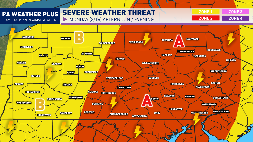
ZONE 2 (A)- Watching for *SCATTERED* strong to severe thunderstorms. These storms may produce damaging wind gusts of 55 to 70 MPH. A few spin-up weak tornadoes are not ruled out, and if one were to occur, it would likely be low intensity (EF0-EF1). Non-severe thunderstorms may still produce gusty winds, lightning, and heavy rainfall. I am watching for portions of this zone to be upgraded to a Zone 3 NUMEROUS risk over the upcoming days, especially for those in the Damaging Wind Risk Scale of 5 or greater. This includes towns/cities such as: Scranton, Williamsport, Easton, State College, Lancaster, Harrisburg, and Philadelphia
ZONE 1 (B)- Watching for *ISOLATED* strong to severe thunderstorms. These storms may produce strong wind gusts of 50 to 60 MPH. Non-severe thunderstorms may still produce gusty winds, lightning, and heavy rainfall. This includes towns/cities such as: Erie, Oil City, Butler, Clearfield, Indiana, Pittsburgh, Washington, Greensburg, Uniontown
Keep in mind, severe weather does not impact every house or neighborhood. Unless it is a large outbreak, severe weather impacts will differ even across small areas. It is always good to be prepared by having multiple ways of receiving severe weather alerts and a shelter to take cover in when severe weather strikes.
TOWN/CITY TIMING OUTLOOK:
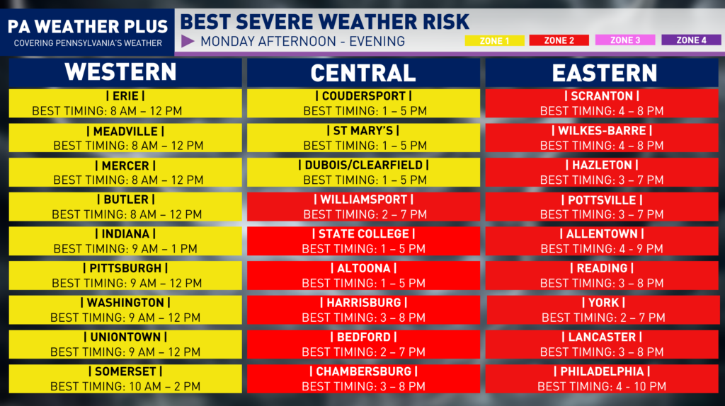
While this graphic was popular in the winter for winter precipitation start/end times, I thought of bringing this back with a ‘best timing’ scale for the potential for these strong to severe thunderstorms. Keep in mind, ‘best timing’ does not guarantee you will see thunderstorms in that timing, and in some instances may occur outside of this timing box if the environmental conditions change. For a more local percentage and best timing, visit: https://paweatherplus.com/your-local-weather/
Monday will be a good day to remain weather aware and stay tuned for updates. Be prepared for rapidly changing weather conditions. Make sure you have multiple ways to receive severe weather alerts. Remember, when you hear thunder, head indoors! Stay safe and stay tuned! – Denys
