When will we see a dry and stormless weekend again? It does not seem to be a thing here in Pennsylvania. Storms moved through portions of the state this afternoon and evening, with another round poised to move through tomorrow afternoon. This is as a boundary that will move through the state, helping to initiate afternoon showers and storms. There will be high amounts of instability, thanks to the warm and humid airmass in place. The boundary will help to increase the wind shear, which is a change of wind speed and direction with height. With those ingredients, we will have the risk for stronger thunderstorms, particularly in the afternoon and evening hours.
SIMULATED RADAR

By the early morning hours (6-9am), there could be a few areas of sub-severe storms from the lingering activity from the overnight. These will be likely just producing heavy rainfall and some lightning. Any heavier storm may cause a very low risk of flooding, and these are generally expected to be sub-severe.

As we roll over into the early afternoon, our disturbance will begin to fire off a few showers and storms, primarily across northwestern Pennsylvania to begin with. These will slowly begin to slide south and east throughout the afternoon hours. Initially, these are expected to be on the sub-severe side, but cannot rule out one or two that may go quickly on the stronger side and produce gusty winds.

By the mid-afternoon hours, the greatest storm coverage will be across the southern tier of the state. A few sub-severe storms may fire across northern Pennsylvania. This will be our prime time for more stronger thunderstorms that can contain gusty winds of 40 – 60 mph. Additionally, heavier thunderstorms may pose a risk of flash flooding, especially with some areas that may receive more than one storm. This is already an elevated threat with the recent rainfall events leading to saturated soils. Flood-prone and low-lying regions will be at the highest risk. Please remember to turn around, don’t drown!

By the evening hours, much of our activity will begin to push farther south. There may be a few lingering sub-severe storms across northern Pennsylvania that may bring localized heavier rainfall and perhaps some lightning. If anything does linger into this timeframe, it will likely quickly dissipate the farther we get away from sunset.
SEVERE WEATHER ZONES:

ZONE 1 – *ISOLATED* strong to severe thunderstorms are expected. The strongest storms may produce gusty to damaging wind gusts of 45 – 55 mph. Non-severe thunderstorms may still produce heavy rainfall and frequent lightning. LARGER CITIES/TOWNS IN THIS RISK: Pittsburgh, State College, Allentown, Johnstown, Harrisburg, Philadelphia. Monitoring the risk for an upgrade to ‘Zone 2 (scattered)’ if confidence increases across southern Pennsylvania.
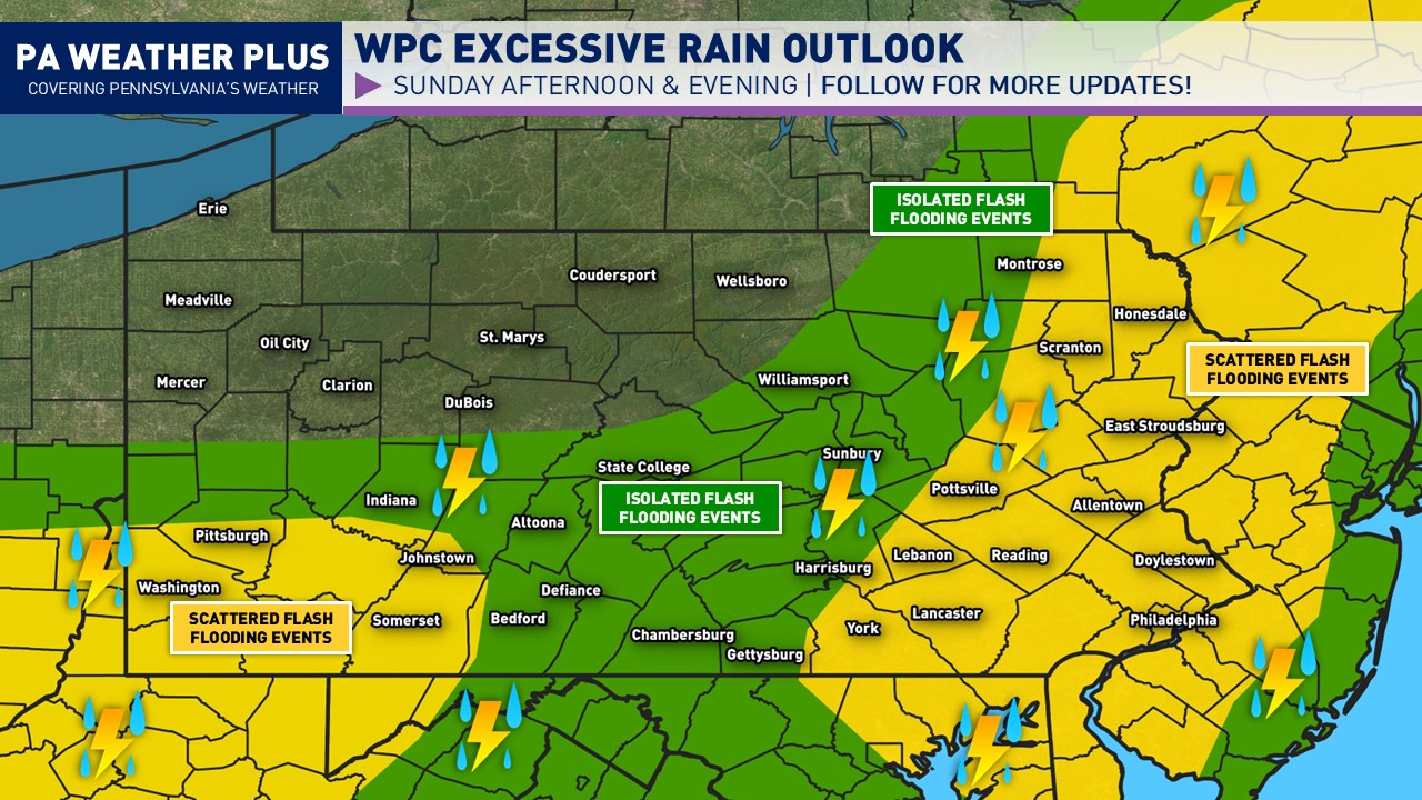
FLASH FLOOD RISK:

In addition to the severe threat, there will also be a flash flood risk. In response, the WPC has placed parts of the region under a flash flood risk (level 1/4 – green, level 2/4- yellow). Scattered flash flooding events are expected in the level 2/4(yellow). Any heavier storm may produce 1-2″+/hr rates, which will lead to flash flooding. A few localized spots may see up to 2 inches or more of rain. Flash flooding may occur in as little as minutes in the heaviest thunderstorms. Heed all flash flood alerts issued tomorrow! Stay tuned for more updates regarding this risk. Remember: TURN AROUND DON’T DROWN. Share with friends and family!
IN-DEPTH TIMING OUTLOOK:

While this graphic was popular in the winter for winter precipitation start/end times, I thought of bringing this back with a ‘best timing’ scale for the potential for these strong to severe thunderstorms. Keep in mind, ‘best timing’ does not guarantee you will see thunderstorms in that timing, and in some instances, may occur outside of this timing box if the environmental conditions change. For a more local percentage and best timing, visit: https://paweatherplus.com/your-local-weather/
Tomorrow will be a good day to remain weather aware and stay tuned for updates. If you want something more specific to your location, please reach out via Facebook Messenger or PM [email protected]. Stay safe and stay tuned!