It really is a never-ending winter of blasts of cold air and accumulating snowfall events. While we had a short break since the last winter storm in late January, we have another accumulating snow event on our doorstep, which will just add onto the glaciating snowpack across the state! Read below for all of the details.
If you are here for the snowfall map only, press “FINAL CALL SNOWFALL AMOUNTS” to jump to the bottom of the article!
CLICK TO JUMP TO THE FOLLOWING:
METEOROLOGY SET-UP:
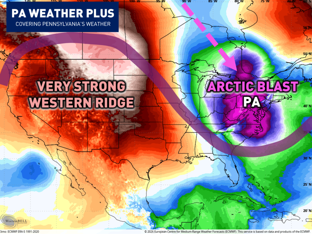
You can often think of a weather pattern as a seesaw. This is exactly what will lead to our strong arctic blast this weekend. With much of the western United States experiencing a strong ridge (with well-above-average temperatures), this forces a “down” across the eastern United States. This will lead to a strong arctic outbreak across Pennsylvania and the rest of the Northeast.
Unfortunately, this “down” across the eastern US will align with a dipping TPV (Tropospheric Polar Vortex). The tropospheric polar vortex is the polar vortex at the lowest layer of the atmosphere (where our weather happens). There’s also a stratospheric polar vortex higher up, but the tropospheric one is the one that most directly influences our day-to-day winter weather. The TPV helps to bring down some of the most extreme arctic outbreaks, and this is what will cause our temperatures to be much colder than we’ve seen this past winter (along with much windier conditions).
Ahead of this arctic blast, we will see a clipper system and arctic front, which will bring light snowfall amounts to the entire state of Pennsylvania.
FUTURE RADAR TIMING:
Snow showers will begin to move into western Pennsylvania by the early morning hours. These will spread east throughout the day. The best chance for the steadiest snow will be across western Pennsylvania. A second wave of energy prolonging the snowfall across eastern Pennsylvania into the overnight hours. Central PA will see the “dip” between these two waves, which will lead to lower snowfall amounts.
I have a page on the website dedicated to giving you a more accurate timing forecast for your given location. Check it out here! Your Local Weather
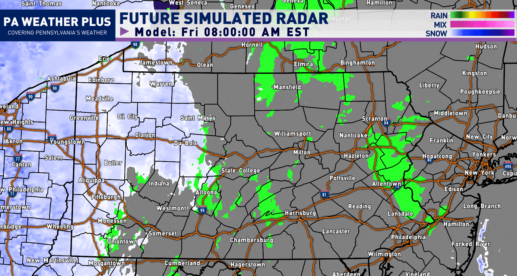
Ignore the “rain” showing up ahead and behind the snow shield- that is an internal error on the software (it is snow “falling” but not reaching the ground due to initial dry air).
STRONG WIND GUSTS SATURDAY / POWER OUTAGE RISK:
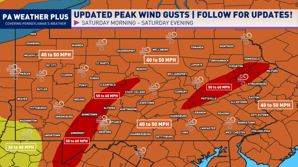
Peak wind gusts are expected to range from 40 to 60 MPH for most locations. The strongest winds could down trees and power lines. This can lead to scattered power outages, and may make travel difficult—especially for high-profile vehicles. Loose outdoor objects such as trash cans, decorations, and lightweight furniture could easily be blown around or carried away.
Periods of extreme cold can become especially dangerous if power outages occur. Without heat, indoor temperatures can drop quickly, increasing the risk of hypothermia, frostbite, and frozen pipes. Even short-term outages during very cold weather can create hazardous living conditions, particularly for the older, young children, and pets. Residents should ensure they have extra blankets, charged devices, flashlights, and a safe backup heat plan if available.
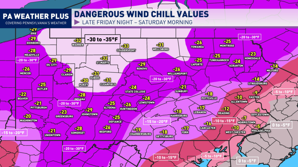
DANGEROUS WIND CHILL:
MINIMUM WIND CHILL FRIDAY NIGHT – SATURDAY MORNING:
MINIMUM WIND CHILL SATURDAY NIGHT – SUNDAY MORNING:
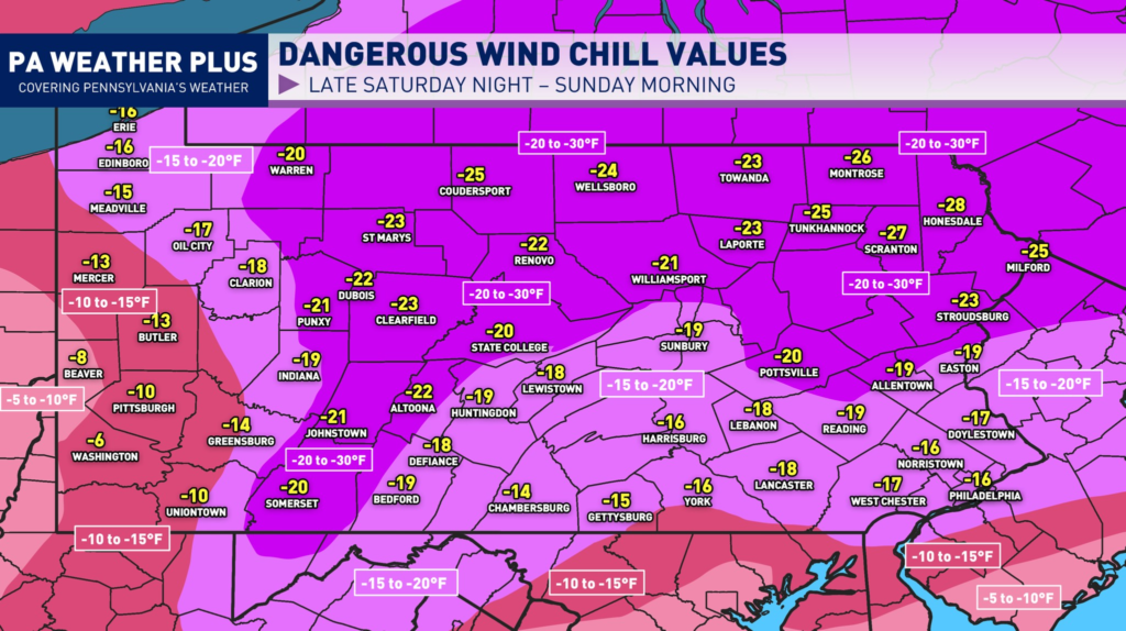
When wind chill values drop this low, the cold air can affect your body much faster. Strong winds pull heat away from exposed skin, which greatly increases the risk of frostbite and hypothermia. Even temperatures that don’t seem extreme can become dangerous when combined with wind, so it’s important to take precautions anytime wind chills fall near or below zero.
If you are planning to be outdoors Friday night through Saturday and even into Sunday take precautions. Make sure to dress in multiple loose-fitting layers to trap heat and stay dry. Start with a moisture-wicking base layer, add an insulating middle layer like fleece or wool, and finish with a windproof and waterproof outer shell. Cover exposed skin as much as possible. Do this by wearing a hat, gloves, a scarf, and insulated, waterproof boots with thick socks. Hands, ears, nose, and cheeks are usually the first areas to develop frostbite.
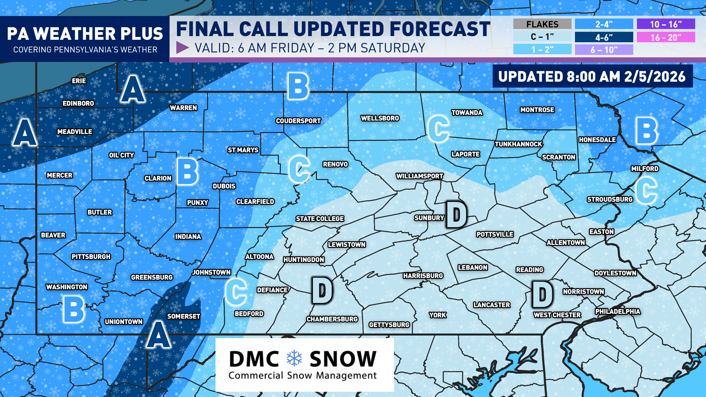
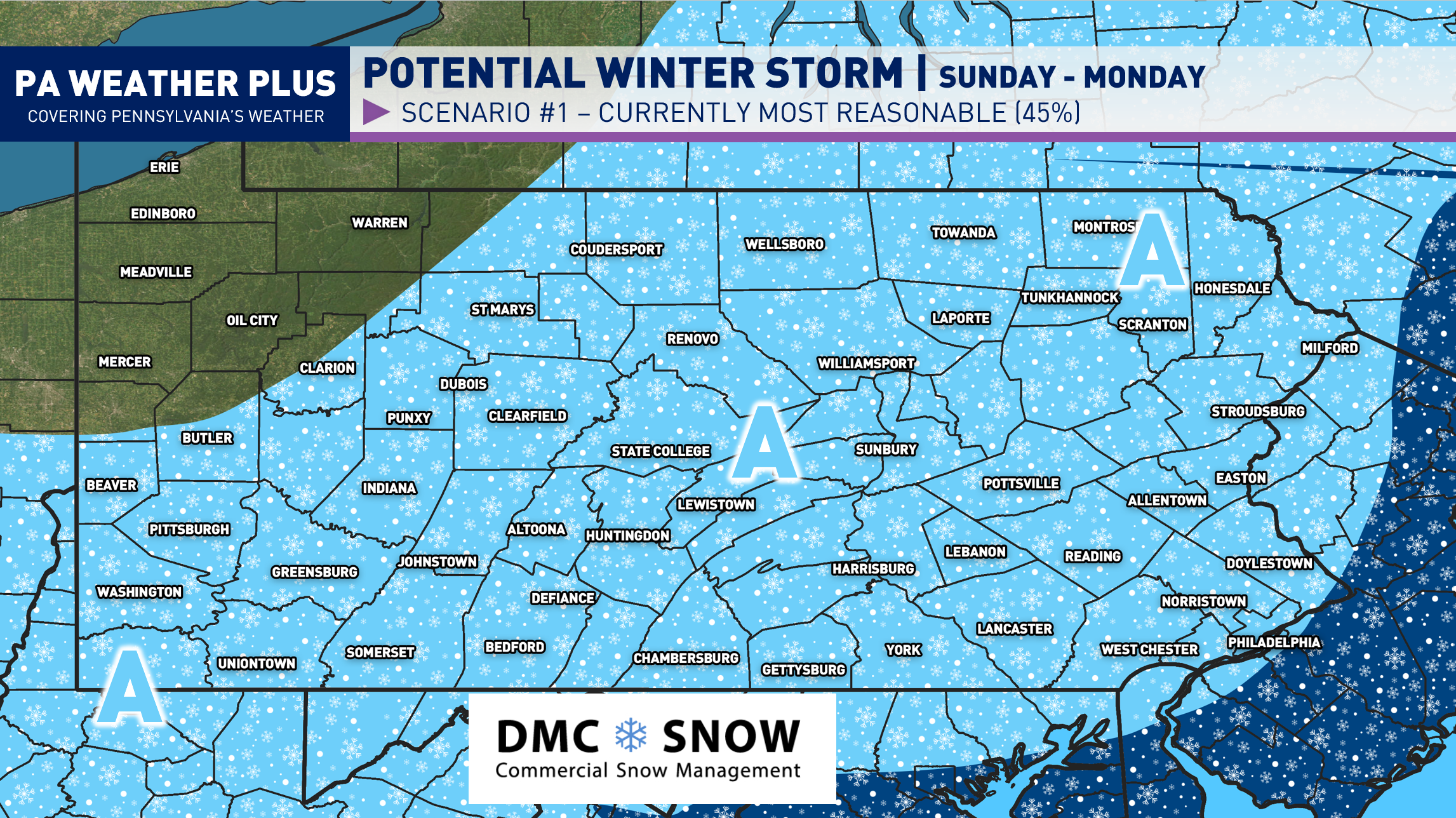
FINAL CALL SNOWFALL FORECAST:
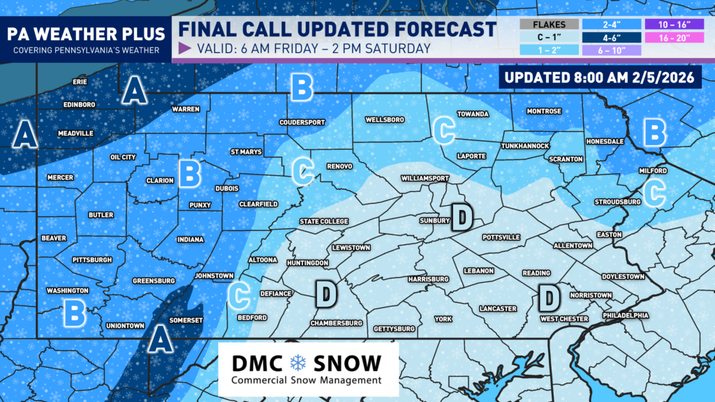
AREA A: 4 to 6 inches of snow is expected. Roadways will become snow-covered during intense snow showers and snow squalls. Some school/business closures are possible across western Pennsylvania, where the snow is expected to begin earlier in the morning.
AREA B: 2 to 4 inches of snow is expected. Roadways will become snow-covered during intense snow showers and snow squalls. Some school/business closures are possible across western Pennsylvania, where the snow is expected to begin earlier in the morning.
AREA C: 1 to 2 inches of snow is expected. Roadways may become snow-covered during intense snow showers and snow squalls, especially Friday night into Saturday morning across this area.
AREA D: A coating to 1 inch of snow is expected. Areas of drier air will limit the potential for steadier snowfall. Any snow squall or heavier snow shower may cover roadways.
CONCLUSION:
Make sure to prepare for the snow, higher wind gusts, and frigid temperatures! If you are prone to losing power, be prepared, as temperatures will be stuck in the single digits for many locations with wind chill of -10 to -30 throughout the day. Watch for rapidly changing weather conditions with snow showers and squalls Friday through Friday night. I will have more updates on Facebook and other social media platforms throughout the weekend. Stay tuned and stay safe!
CLICK HERE TO FOLLOW ON FACEBOOK!
-Denys