A stationary front will bring active weather to the state throughout the weekend. I mean, who isn’t surprised it was a nice and sunny workweek with showers/storms returning by the weekend?! I am not! Anywho, this stationary front will also increase the humidity with dew points climbing into the low-to-mid 70s (iso upper-70s), which will make a concern for higher heat indices (especially on Friday). Saturday and Sunday will be stupidly humid as well, although showers and storms will help to cap the extreme heat index values.
NOTE: Every day is not expected to be a complete washout, although periods of increased storm activity are expected. If you have outdoor plans, it would be wise to stay tuned for weather updates and remain aware of rapidly changing weather conditions. If you need a localized wx forecast for your weekend plan/activity, please email [email protected].
Here’s what you can expect day-by-day in Pennsylvania this weekend:
FRIDAY, JULY 27TH:

Friday will begin the state of our active weather weekend, with the front beginning to move into the northern half of the state. Friday will be the hottest day of the weekend, with highs expected in the upper-80s to mid-90s for many, hotter the farther south and east you are located. With higher dew points expected, this will make for dangerous heat indices, likely over 100 degrees for many southern PA locations. Additionally, the heat and humidity will help fuel the risk for perhaps a few stronger thunderstorms.
Larger towns/cities at greatest risk: Erie, Pittsburgh, Scranton, State College, Allentown
AREA A – Scattered (35 – 55%) chance of showers and thunderstorms, primarily between 12 – 8 PM. Heavier and stronger thunderstorms may cause a risk of flash flooding and strong winds. A severe weather risk and flash flood map will likely be needed for Friday. Stay tuned for updates!
AREA B – Isolated (15-35%) chance of showers and thunderstorms, primarily between 2 – 10 PM. Any stronger or heavier thunderstorm may cause the risk of flash flooding and perhaps gusty winds. The farther south you are in this zone, the more likely your storm threat will come later in the evening.

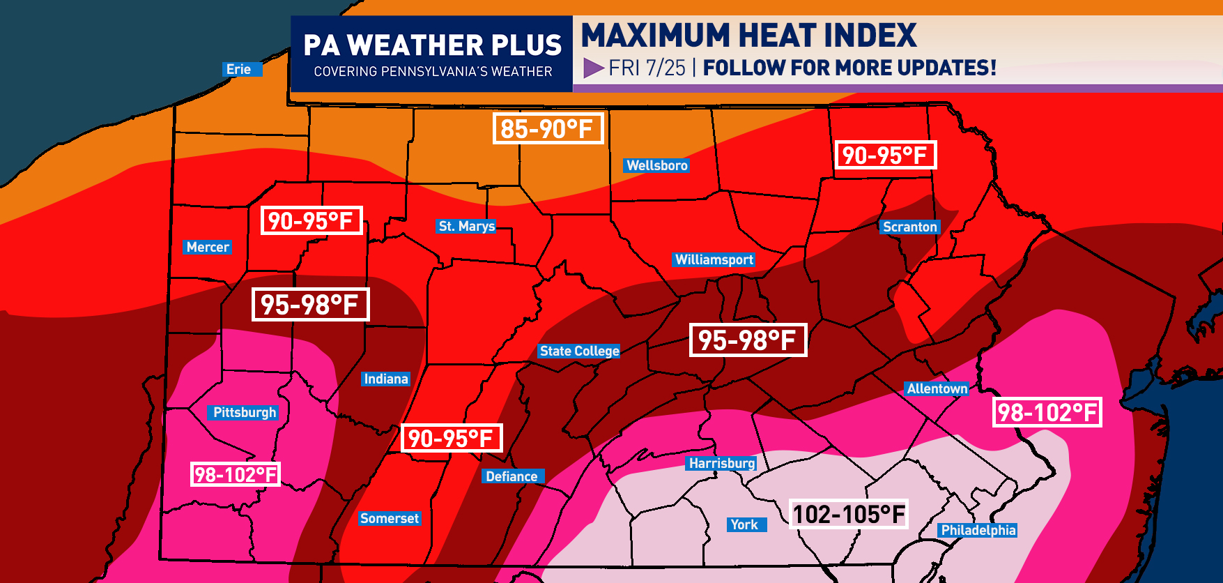
Here is an early look at the *MAXIMUM* heat index expected Friday afternoon. The very high dew points combined with higher temperatures will make for DANGEROUS heat indices, especially across southern PA. Pittsburgh, Harrisburg, York, Allentown, Lancaster, Doylestown, and Philadelphia will see heat indices climb into the upper-90s to lower-100s. If you plan on being outdoors Friday afternoon, please stay hydrated (DRINK WATER!!!) and avoid strenuous activities during the hottest parts of the day (12-4pm). Check on elderly neighbors often, and do not leave children, pets, or anyone unattended in vehicles. Stay tuned and follow for more updates.
SATURDAY, JULY 26:

By Saturday, the stationary front will sag farther to the south. This will bring a higher threat for showers and storms into much of the Commonwealth throughout the late morning, afternoon, and evening hours. There will be concern for flash flooding in any heavier thunderstorm, and a low-level severe weather risk cannot be ruled out.
AREA A – Scattered (35 – 55%) chance of showers and thunderstorms, primarily between 10 AM – 8 PM. Heavier and stronger thunderstorms may cause a risk of flash flooding and strong winds. A severe weather risk and flash flood map will likely be needed for Saturday. Stay tuned for updates!
AREA B – Isolated (15-35%) chance of showers and thunderstorms, primarily between 10 AM – 8 PM. Any stronger or heavier thunderstorm may cause the risk of flash flooding and perhaps gusty winds.
SUNDAY, JULY 27TH:

There is still some uncertainty regarding Sunday, but the front will begin to push farther south and east, bringing the best chance for showers and storms across southern and eastern Pennsylvania.
AREA A – Scattered (35 – 55%) chance of showers and thunderstorms, primarily during the mid-afternoon through evening hours. Heavier and stronger thunderstorms may cause a risk of flash flooding and strong winds. A severe weather risk and flash flood map may be needed for Sunday. Stay tuned for updates!
AREA B – Isolated (15-35%) chance of showers and thunderstorms, primarily during the late morning through mid-afternoon hours. Any stronger or heavier thunderstorm may cause the risk of flash flooding and perhaps gusty winds.
🔎 Quick Final Summary:
- 🔥 Dangerous heat expected Friday with heat index over 100°F
- ⛈️ Scattered storms each day – best chance Saturday afternoon
- 🌧️ Flash flooding & strong winds in storms possible Friday–Sunday
- 🗺️ Areas most at risk: Erie, Pittsburgh, State College, Allentown, Philadelphia
That is all for this early preview of the Pennsylvania weekend outlook. I hope to continue to expand these to bring more details to your weekend weather. If you have any questions, please feel free to reach out!
FIND YOUR LOCATION FORECAST HERE: https://paweatherplus.com/your-local-weather/
– Meteorologist Denys K