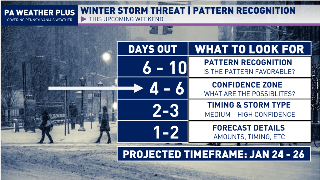
After what feels like a decade (which it nearly has been), the pattern is loading up to produce a potentially large and significant winter storm. We have an Arctic airmass in place, multiple jet-streams phasing in, and strong pieces of energy allowing for a potential blockbuster winter storm. Whether Pennsylvania sees significant impacts will be dependent on how far north the storm system tracks.
WINTER STORM POTENTIAL:
Usually, I don’t throw around the word “significant” or “major” 4+ days out, but between the recent model guidance, ensembles, and looking at the incoming pattern, this storm has the potential to be quite significant. We are going to have a lot of moisture and warm air ramming into an upper-echelon Arctic airmass this weekend, which is favorable for moisture to be running into the airmass, essentially “squeezing” out and dropping very heavy snowfall wherever the low pressure tracks. Not only that, but we will have a western US Ridge, a strong negative NAO block, and a 50/50 low, which supports a slow-moving large winter storm. These pieces have not aligned in what feels like years.
OVERALL METEOROLOGICAL PATTERN:
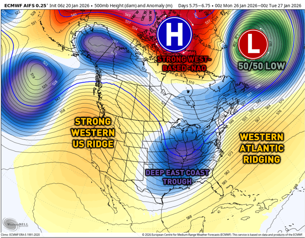
The overall pattern from a meteorology perspective looks to fit a major winter storm. All of the ingredients that meteorologists look for at 500 MB are lining up. A 50/50 low combined with a strong west-based negative NAO block. Additionally, a strong western ridge will allow for the East Coast trough to dig into the southeastern United States. Western Atlantic ridging will allow for the pattern to slow down, and we get a low-pressure system to develop on the East Coast.
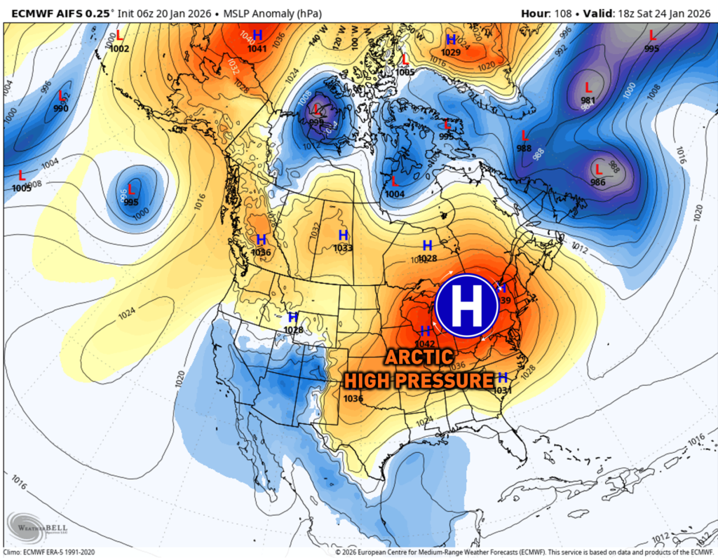
Leading up to the storm, a strong Arctic high-pressure system of 1040 – 1050mb will allow for deep, Arctic air to settle in across much of the Eastern United States. This will initially keep the storm into the southern United States before the High Pressure begins to retract, allowing for the low-pressure system to climb north.
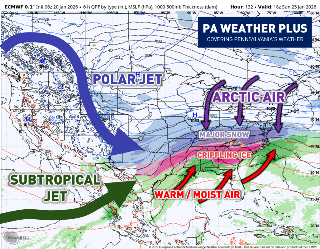
With all of the ingredients coming together, this is what will possibly look at the surface. You have your polar jet stream phasing in with the subtropical jet stream, allowing for colder air to phase in with a warm/moist airmass. Arctic Air will be filtering on the East Coast, allowing for major snow and crippling ice storms across much of the country from Texas through the East Coast. For us here in Pennsylvania, we will need to watch how the storm gains latitude throughout the weekend.
CURRENT QUESTIONS OF UNCERTAINTY:
How fast does the high-pressure system retract? A quicker retraction will allow for the storm pressure to climb more northward. A slower retraction will allow for the storm to hold more southward, impacting areas south of Pennsylvania.
Will the Baja low-pressure system phase into the pattern? A phase will allow for ridging across the southeastern United States, allowing for the storm to gain latitude and climb northward. No phasing and it being held back will allow the system to remain temperature-driven, keeping the worst of the storm south of Pennsylvania.
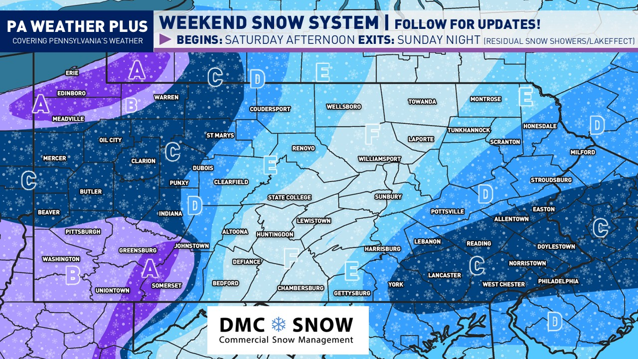
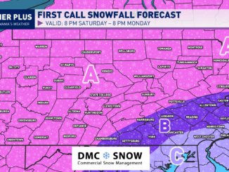
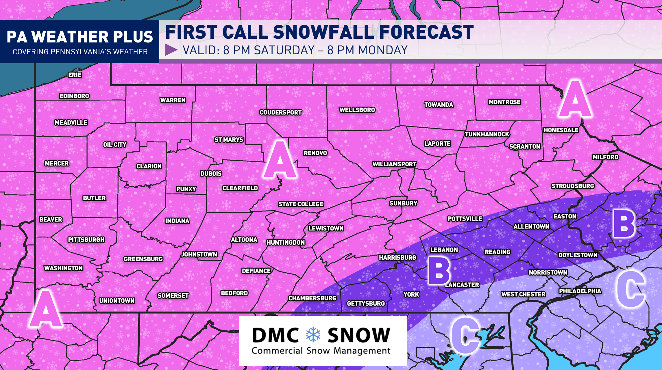
EARLY POTENTIAL IMPACTS:
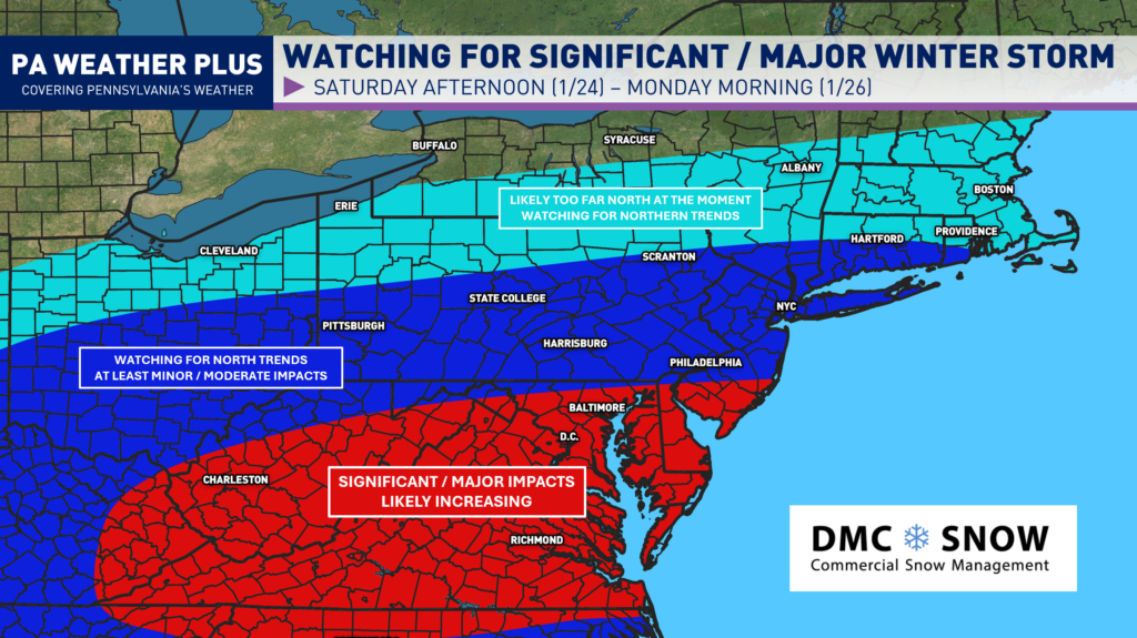
RED COLOR: Watching for significant to major winter storm impacts. Confidence is growing for a long-term winter storm throughout the weekend, including impacts from either heavy snowfall and/or icing.
DARK BLUE COLOR: Watching for at least minor to moderate impacts. Confidence is growing for *at least* some impacts. If the trend is more north, significant/major impacts cannot be ruled out. If the trend is more south, minimal to minor impacts can be expected.
LIGHT BLUE COLOR: Likely too far north at the moment, but watching for trends. Minimal to minor impacts can be expected, although a northern trend can substantially increase the threat. A southern trend will allow for deep Arctic air to settle in with dry weather.
For a 48-hour forecast for your location, check out our page here! YOUR LOCAL WEATHER
WHAT SHOULD YOU DO NOW?
![]() If you are a snow-lover and hoping for a big snowstorm, this one will have potential to be the “big” one we haven’t seen in years *ONLY* if the Arctic high doesn’t shove it south. Don’t get your hopes up until Wednesday/Thursday if you are south of Pennsylvania.
If you are a snow-lover and hoping for a big snowstorm, this one will have potential to be the “big” one we haven’t seen in years *ONLY* if the Arctic high doesn’t shove it south. Don’t get your hopes up until Wednesday/Thursday if you are south of Pennsylvania.
![]() If you are a person who likes the heads-up days in advance, then stay tuned for updates.
If you are a person who likes the heads-up days in advance, then stay tuned for updates.
![]() If you would rather not know until the day before, then kindly scroll and leave your negative comments to yourself. You don’t have to tell me that it will change. It will change.
If you would rather not know until the day before, then kindly scroll and leave your negative comments to yourself. You don’t have to tell me that it will change. It will change.
It will be quite a week ahead tracking trends, whether it continues to shift north or shove back south. I will be on top of it all week- stay tuned for updates! I will have more updates on the Facebook page!
-Meteorologist Denys K.