The lake effect snow machine has not turned off yet for the winter season! As long as Lake Erie remains unfrozen, blasts of Arctic air will continue to produce lake effect snowstorms throughout the rest of the season. Back in September, I noted this upcoming winter to be particularly active for lake effect, and that is still holding true!
If you are only here for the snow map, press “SNOWFALL FORECAST TUESDAY NIGHT – THURSDAY AFTERNOON” UNDER ‘JUMP TO THE FOLLOWING.’
JUMP TO THE FOLLOWING:
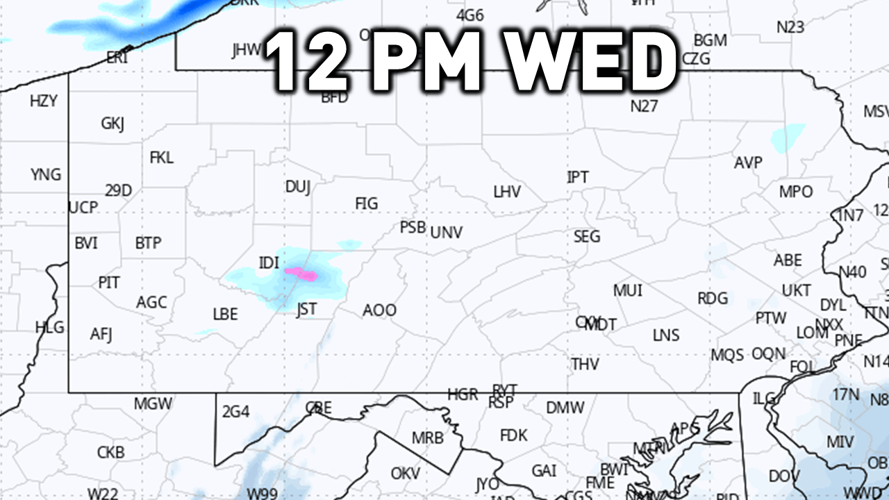
SIMULATED FUTURE RADAR:
Here is a GIF simulating the future radar from Wednesday morning through early Thursday morning. This is when I believe the potential snow risk will be the most impactful. If you live in northwestern Pennsylvania, you will continue to see snow before and after the simulated radar loop. If you are planning to travel in northwestern Pennsylvania, be prepared for rough travel conditions anytime Tuesday night through Thursday afternoon.
Given this is a simulation, some of the intense lake effect snow bands before the main system moves through may also not be modeled to their true intensity and coverage zone. Keep this in mind!
I have a page on the website dedicated to giving you a more accurate timing forecast for your given location. Check it out here! Your Local Weather
SNOW SQUALL INFORMATION:
What is a snow squall? A snow squall is an intense, short-lived, heavy burst of snowfall accompanied by gusty winds. Think of them as thunderstorms without the rain. Some intense snow squalls may have lightning! Squalls this afternoon may produce a quick half inch to an inch of snowfall in as little as 30 minutes.
Why should you care? Snow squalls are VERY dangerous when it comes to travel, especially on interstates. Snow squalls have had a history of producing multi-car pileups on interstates in past years across the state.
Within a snow squall, be on alert for RAPIDLY deteriorating conditions in as little as MINUTES. Even if road conditions are wet prior to the squall, a flash freeze may occur and make for very slick conditions. Snow squalls may lead to chain-reaction accidents and very hazardous travel.
What should you do if you are caught in a snow squall? Get off the highway. Consider an alternate route or delaying your travel. Reduce your speed and turn on your headlights. If you are caught in a multi-vehicle pileup, DO NOT stand outside of your vehicle or on the roadway.
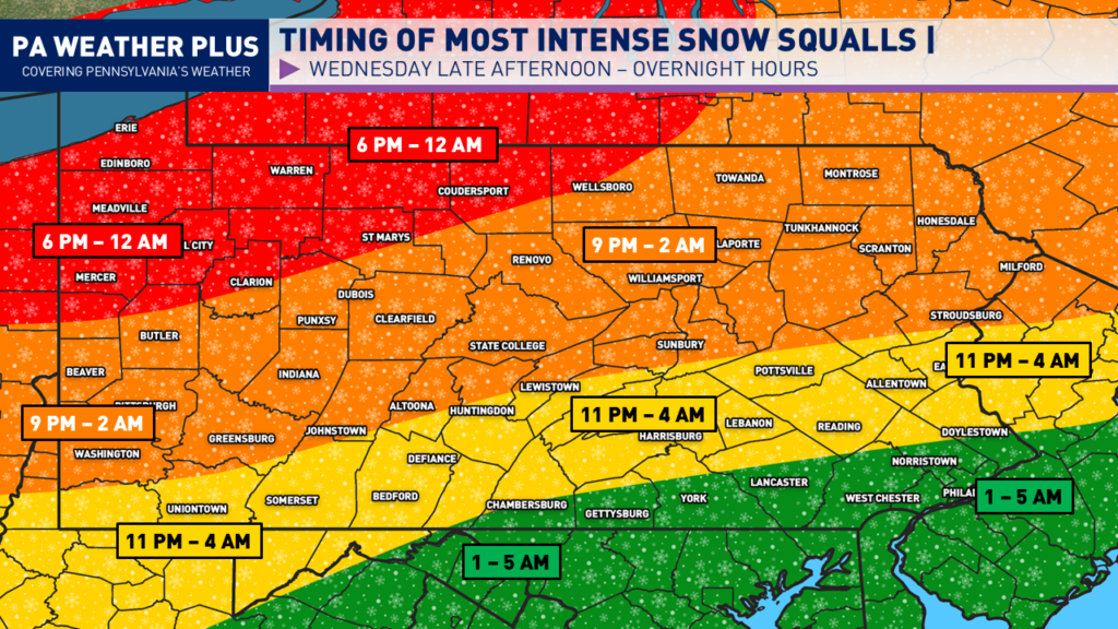
SNOW SQUALL TIMING (WEDNESDAY):
Snow squalls will become more numerous as our clipper system moves in northwest-to-southeast on Wednesday, December 31st and into the night on January 1st. Here is the current timing to see the most intense snow squalls. If you are planning to be out on the roadways during the time of the snow squalls, please mind the rapidly changing weather conditions. Keep in mind, heavy lake effect snow bands may continue in the red-colored zone beyond the timing of the most intense snow bands.
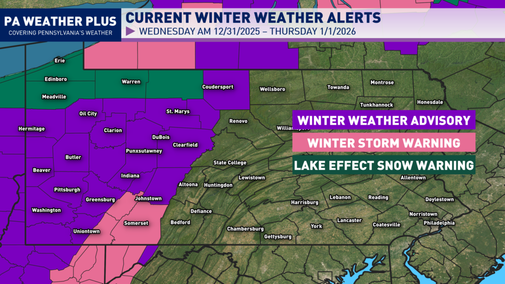
WINTER WEATHER ALERTS:
These winter weather alerts are as of 7am on Wednesday, December 31st. Check back on weather.gov for an updated look at the alerts as we progress throughout the event.
A Winter Weather Advisory is currently in effect for Allegheny, Armstrong, Beaver, Belmont, Brooke, Butler, Cambria, Cameron, Carroll, Clarion, Clearfield, Columbiana, Elk, Fayette, Forest, Greene, Hancock, Harrison, the higher elevations of Indiana, Indiana, Jefferson, Lawrence, Marion, Marshall, Mercer, Monongalia, Monroe, Ohio, Potter, Tuscarawas, Venango, Washington, Westmoreland, and Wetzel Counties, where periods of snow and slick travel conditions are expected.
A Winter Storm Warning is in effect for Eastern Preston, Eastern Tucker, the Fayette Ridges, Preston, the ridges of Eastern Monongalia and Northwestern Preston, Somerset, Western Tucker, and the Westmoreland Ridges, where heavy snow and dangerous travel conditions are expected.
A Lake Effect Snow Warning is in effect for Crawford, McKean, Erie, and Warren Counties, where periods of heavy lake-effect snow may lead to hazardous travel conditions, reduced visibility, and rapidly changing road conditions.
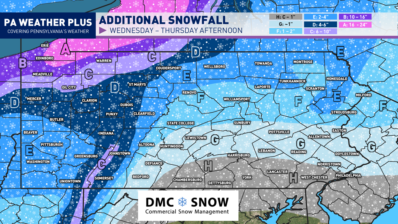
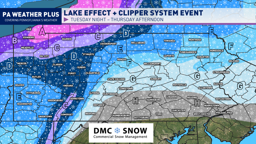
SNOW FORECAST TUESDAY NIGHT – THURSDAY AFTERNOON:
Interstates / major roadways that may be impacted across the state: Interstates I-76, I-78, I-79, I-80, I-81, I-83, I-90, and I-476, along with U.S. Routes 6, 15, 20, 22, 30, 62, 119, 209, 219, 220, 222, and 322.
HEAVY LAKE EFFECT ZONES:
AREA A: 16 to 24 inches of snow expected with locally higher amounts. Expect treacherous travel conditions with snowfall rates exceeding 1″/hr in the heaviest snowfall bands. Travel may become impossible at times. Snow and reduced visibility will significantly impact travel on I-79, I-90, and US-20.
AREA B: 10 to 16 inches of snow expected with locally higher amounts. Expect treacherous travel conditions with snowfall rates exceeding 1″/hr in the heaviest snowfall bands. Travel may become impossible at times. Snow and reduced visibility will significantly impact travel on I-79, I-90, and US-6.
AREA C: 6 to 10 inches of snow expected with locally higher amounts. Expect treacherous travel conditions with snowfall rates exceeding 1″/hr in the heaviest snowfall bands. Travel may become impossible at times on I-79, US-62, and US-322.
LIGHT TO MODERATE ACCUMULATION ZONES:
AREA D: 4 to 6 inches of snow expected with locally higher amounts. Expect slow travel with brief moderate to heavy snowfall rates in localized banding. Travel may become hazardous at times. Snow and reduced visibility will impact travel on I-79, I-80, US-119, US-219, and US-322.
AREA E: 2 to 4 inches of snow expected with localized amounts up to 5 inches. Expect slow travel with brief moderate to heavy snowfall rates in localized banding. Travel may become hazardous at times. Snow and reduced visibility will impact travel on I-80, US-6, US-15, and US-219.
AREA F: 1 to 2 inches of snow expected. Snow showers are expected to be generally light to moderate, but squalls may briefly reach heavy intensity. Expect slow travel with reduced visibility during snow squall activity. Watch for slick travel on I-80, US-15, US-220, US-322.
VERY LIGHT ACCUMULATION ZONES:
AREA G: Up to 1 inch of snow expected, localized amounts are possible up to 2 inches. Snow showers are expected to be generally light to moderate, but squalls may briefly reach heavy intensity. Expect slow travel with reduced visibility during any snow squall.
AREA H: Coating to 1 inch of snow expected. Snow showers are expected to be generally light to moderate, but squalls may briefly reach heavy intensity. Expect slow travel with reduced visibility during any snow squall.
I will provide more updates over the next 12 hours! Stay tuned and stay safe!
-Meteorologist Denys K.