

December refuses to let up across Pennsylvania. After multiple rounds of cold air and accumulating snow earlier this month, attention now turns to the next—and potentially most impactful—winter storm so far. This system is expected to bring significant travel impacts, with either an ice storm or a heavy snowstorm likely, depending on your location. Read below for all of the important details!
JUMP TO THE LETTER DESCRIPTIONS BY PRESSING FINAL CALL / SNOW ICE FORECAST
JUMP TO THE FOLLOWING:
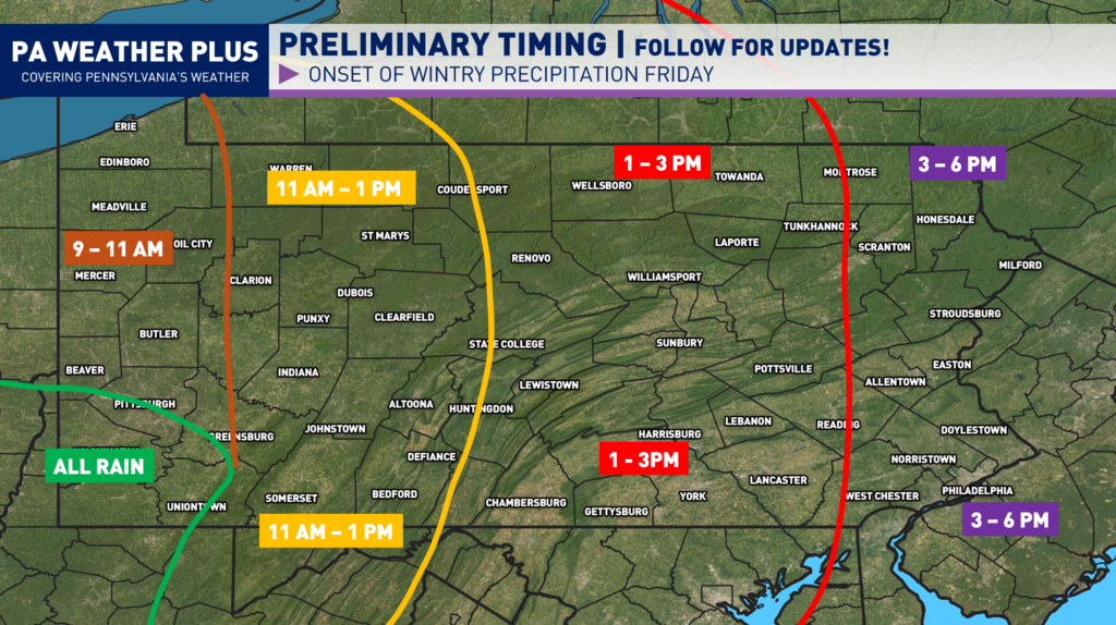
WHEN WILL WINTRY PRECIPITATION BEGIN?
The winter storm is on track to arrive tomorrow late morning and into the afternoon hours. There has already been a trend toward a faster arrival of wintry weather. The farther west you are located, the sooner the winter precipitation will begin. As I noted, these storm systems tend to move in quicker than expected. While I no longer see a shift to be even sooner, keep this in mind if you are planning to travel before the storm arrives. I will continue to update as needed.
WINTER WEATHER ROAD CONDITIONS & TIMING:
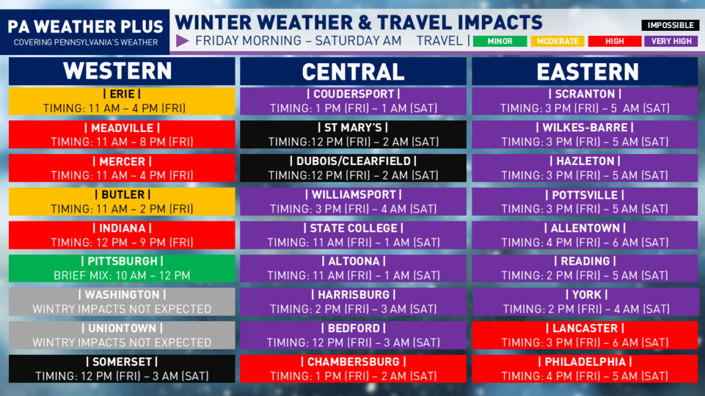
IMPOSSIBLE: Widespread ice accumulation will render nearly all roadways impassable, including major highways and interstates. Travel will be impossible for most vehicles, with a high likelihood of stranded motorists, jackknifed trucks, and emergency response delays. Do not travel under any circumstances unless it is life-threatening. Watch for falling trees and power lines on roads due to heavy icing.
VERY HIGH: Widespread snow and/or ice will cover nearly all roadways, including major highways and interstates. Severe winter storm conditions will create extremely dangerous travel. Vehicles may become stranded, especially during the heaviest snow and/or ice. Travel will be impossible at times. Do not travel unless absolutely necessary.
HIGH: Snow and/or ice will impact most roadways, including many highways and interstates. Hazardous driving conditions will increase the risk of accidents. Avoid non-essential travel.
MODERATE: Snow and/or ice will affect scattered roadways and some highways. While conditions remain less severe, accidents can still occur. Use caution, reduce speeds, and allow extra travel time.
MINOR: Isolated roadways may become snow- or ice-covered. Impacts remain limited, but slick spots can develop. Stay alert, slow down, and drive with caution.
I have a page on the website dedicated to giving you a more accurate timing forecast for your given location. Check it out here! Your Local Weather
WHEN SHOULD I TRAVEL?
If you have travel plans tomorrow, make plans to make it to your final destination 1 -2 hours before the projected start time for wintry precipitation. Once wintry precipitation begins, the road conditions will rapidly deteriorate throughout the afternoon and evening. Do not risk it!
Road conditions on Saturday will be slow to improve. With falling temperatures, those who see heavy icing and snow may be a while to clear all roadways. Interstates should improve Saturday morning, with back and side roadways improving Saturday afternoon. Some roadways may still be snow or ice-covered through Sunday before we see rapid improvement due to melting with increasing temperatures.
FINAL CALL SNOW / ICE FORECAST:
What has changed: Heavier icing is now expected farther into the Allegheny Plateau. Heavy snowfall axis shifting south after initializing latest observations, leaning toward a snowier scenario within gradient areas.
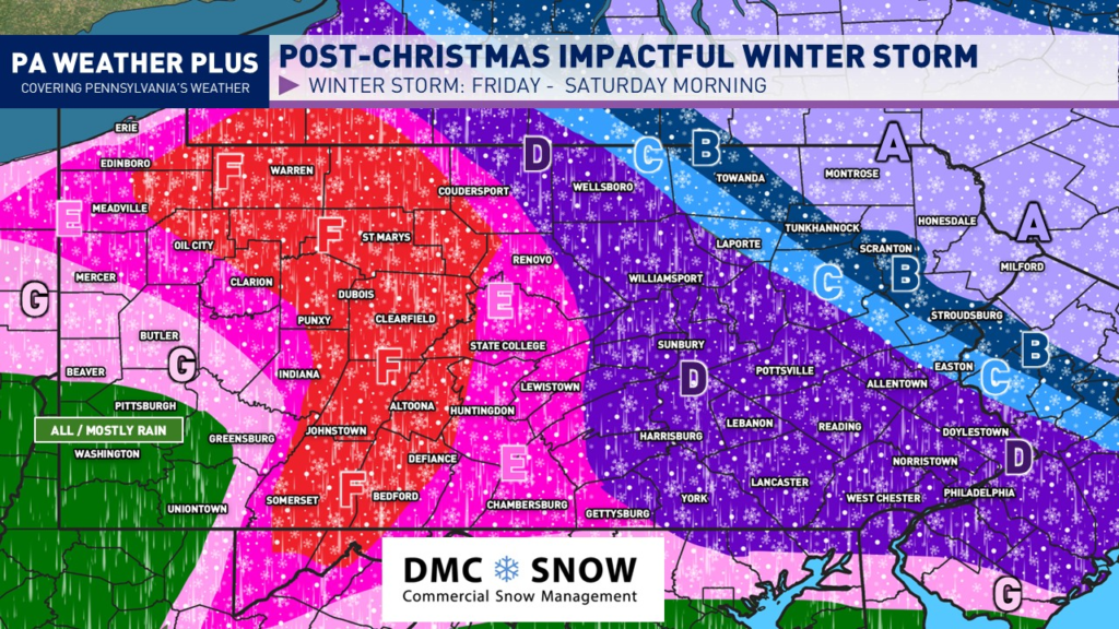
SNOW / SLEET ZONES:
AREA A: Likely all snow. Heavy to very heavy snowfall rates expected during the peak of the storm, upwards of 2″+/hr. Total snowfall accumulations of 7 to 11 inches are expected. Expect nearly impossible travel conditions throughout the storm.
AREA B: Likely mostly snow, mixing with sleet at times. Heavy snowfall rates are expected during the peak of the storm, exceeding 1″/hr at times. Total snow and sleet accumulations of 4 to 7 inches are expected. Expect nearly impossible travel conditions throughout the storm.
AREA C: Mixing between heavy snow and heavy sleet. A brief period of freezing rain is not ruled out. While snowing, snowfall rates may exceed 1″/hr at times. Total snow and sleet accumulations of 2 to 4 inches are expected. Expect nearly impossible travel conditions throughout the storm.
SLEET / FREEZING RAIN ZONES:
AREA D: Mixing between bursts of snow and heavy sleet. Sleet may changeover to freezing rain for periods of time. Total snow and sleet accumulations of 1 to 2 inches. Up to a tenth of an inch of freezing rain is possible. Expect nearly impossible travel conditions throughout the storm.
AREA E: Bursts of some snow and mostly sleet at onset, changing over to freezing rain. Freezing rain will continue throughout the remainder of the storm’s duration. Total freezing rain accretion of 0.10 – 0.25″ expected. Total snow and sleet accumulations of up to 1 inch. Expect nearly impossible travel conditions throughout the storm.
AREA F: Greatest potential for a significant ice storm. While precipitation may briefly begin as snow and sleet, expect prolonged periods of steady freezing rain throughout the remainder of the storm. Total freezing rain accretion of 0.25 – 0.50″ expected. Heavier freezing rain accretion will lead to power outages and downed trees. Expect impossible travel conditions.
FRINGE ZONES:
AREA G: Precipitation will begin as periods of sleet and freezing rain before changing to rain. A trace to localized areas of 0.10″ of freezing rain accretion is expected. Travel may be icy for periods of time in the early portions of the event.
ALL RAIN AREA: Sorry, Pittsburgh region. Too warm. Although, consider yinz as luck because an ice storm is not fun to deal with!
Thank you for tuning in and reading through all of the forecast details. I will continue to post updates on Facebook, Instagram, and X. Make sure to follow PA Weather Plus on all of those platforms! I appreciate EVERYONE’S support. Reach out with any questions and/or concerns.
-Meteorologist Denys K
