As to no surprise, our active summer of severe weather continues. A strong cold front is poised to cross the state Sunday afternoon and evening, bringing the severe weather risk. Ahead of the cold front, higher temperatures and humidity will aid in severe weather ingredients such as instability and wind shear. With a stronger-than-average cold front for July, the wind shear values will be a bit higher than we typically see, which may increase a localized risk of severe weather in some places, especially across Zone 2. The primary storm type will be thunderstorm clusters with the risk for one or two isolated bowing segments that may bring a higher severe weather risk.
SIMULATED RADAR

By the early afternoon (11 AM – 1 PM), thunderstorms will begin to develop across northwestern Pennsylvania ahead of the cold front. These initial showers/storms will likely remain sub-severe.

By the mid-afternoon, the best storm coverage will remain across the northern half of the state, with isolated coverage in the southern portions. A few of these storms across north-central and northeastern PA may become a bit more fierce and contain bowing segments and/or a supercell.

Toward the later afternoon, the best storm coverage will remain across portions of central and eastern PA, with less coverage across southwestern and south-central PA. Some of these storms may be beginning to leave the best environment and may show signs of weakening.

By the early evening hours, we will begin to lose some of our best ingredients, and any lingering severe weather risk will quickly diminish. Although I cannot rule out one or two showers or stronger cells lingering into southeastern Pennsylvania but anything will then move out and/or dissipate quickly after sunset.
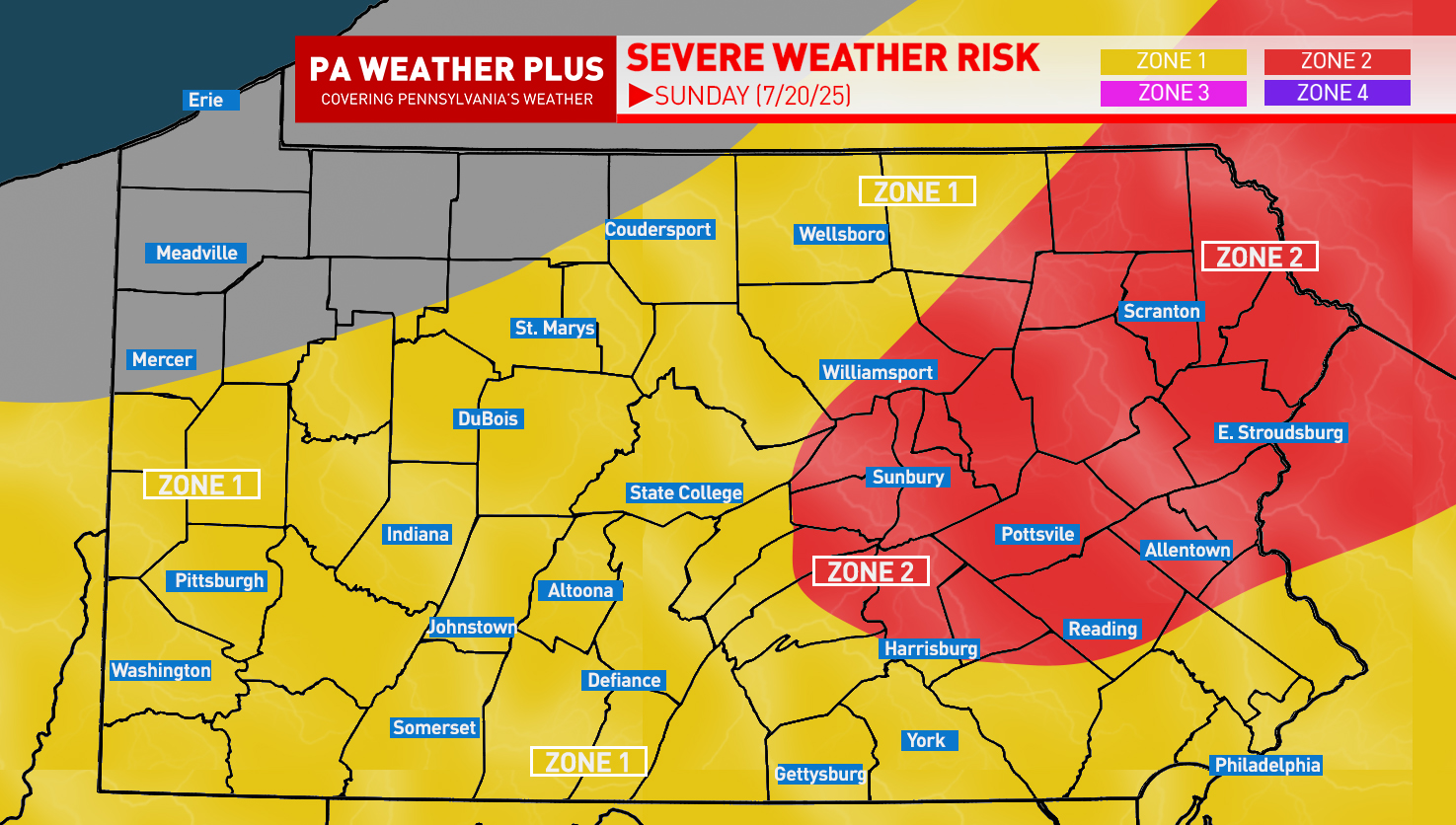
SEVERE WEATHER ZONES:

ZONE 2 – *SCATTERED* strong to severe thunderstorms are expected. The strongest storms will produce damaging wind gusts of 50 – 60 mph. A few storms may have hail up to quarter-sized. Non-severe thunderstorms may still produce heavy rainfall and frequent lightning. LARGER CITIES/TOWNS IN THIS RISK: Scranton, Williamsport, Allentown, Reading
ZONE 1 – *ISOLATED* strong to severe thunderstorms are expected. The strongest storms may produce gusty to damaging wind gusts of 45 – 55 mph. Hail up to penny-sized possible. Non-severe thunderstorms may still produce heavy rainfall and frequent lightning. LARGER CITIES/TOWNS IN THIS RISK: Pittsburgh, State College, Altoona, Johnstown, York, Philadelphia
IN-DEPTH TIMING OUTLOOK:

While this graphic was popular in the winter for winter precipitation start/end times, I thought of bringing this back with a ‘best timing’ scale for the potential for these strong to severe thunderstorms. Keep in mind, ‘best timing’ does not guarantee you will see thunderstorms in that timing, and in some instances may occur outside of this timing box if the environmental conditions change. For a more local percentage and best timing, visit: https://paweatherplus.com/your-local-weather/
Tomorrow will be a good day to remain weather aware and stay tuned for updates. If you want something more specific to your location, please reach out via Facebook Messenger or PM [email protected]. Stay safe and stay tuned!