Estimated reading time: 8 minutes
Hard to believe we are already heading into the fall months! Before we know it, we will be full in swing with the winter months, and that will come with arctic blasts, snow, and ice storms. Due to your high interest, I thought it would be a good chance for me to dive into the future projected winter pattern. This forecast was carefully put together based on the meteorological factors and intuition I had at hand. Let’s dive into the winter forecast preview!
Feel free to jump to the following:
UNDERSTANDING SEASONAL FORECASTING:
When seasonal outlooks are created, forecasters tend to look at the ‘big picture’ of weather patterns rather than the small, minute details that weather could bring day-to-day or even week-to-week. One of the biggest global-driven weather patterns across the globe is called the El Niño/Southern Oscillation or ENSO for short. This is where your phrases such as ‘El Niño’ or ‘La Niña’ originate from.
An El Niño is the positive phase of the ENSO, when the central Pacific Ocean waters are above average. A La Niña is the negative phase of the ENSO, when the central Pacific Ocean waters are below average.
Oceans are the backbone of global weather and seasonal forecasting because they store, move, and exchange enormous amounts of heat and moisture with the atmosphere. Studies have shown that ENSO has a significant impact on weather patterns across the globe, even here in Pennsylvania!
For this upcoming winter, model guidance is in high agreement that the ENSO will remain neutral yet have a lean to the negative side. Due to this, NOAA has released a ‘La Niña’ watch for this upcoming winter. Based on these projections, a weak La Niña winter is pretty likely, with some models even hinting at a moderate La Niña.

PENNSYLVANIA SNOW STATISTICS:
I have coded statistical data to compare the snowfall amounts across 6 major towns/cities across the state of Pennsylvania with the respective ENSO phase since 1985. The first image shows each individual winter (blue dot) with respective ENSO phases and intensity (blue = La Nina, red = El Nino).

In general, most of the state receives greater amounts of snowfall in neutral-ENSO years. Erie benefits more with a colder neutral to weak La Niña. Philadelphia and Harrisburg benefit better with a warmer neutral to El Niño. This is no surprise, as La Niña years usually help to benefit those across the northern tier of the state. El Niño years tend to bring large snowstorms that impact the southern and southeastern portions of the state. As a reminder, this winter is expected to be on the colder side of the ENSO, likely a weak La Niña or, if not, a colder neutral-ENSO.

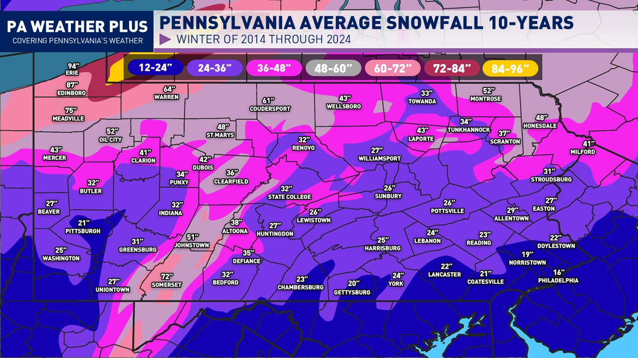
Pictured below is the average snowfall across Pennsylvania over the last 10 winters. The standard 30-year average is important; it is vital to look at recent short-term trends in the past decade. This was compiled with NOHRSC data from 2014 through 2024.

LOOKING AT THE PAST FOR THE FUTURE:
Analogs are another important tool in seasonal forecasting. An analog is a past atmospheric/oceanic pattern (such as ENSO phases or jet stream setups) that could resemble the future. By studying what happened after that past setup, we can gain insight into plausible outcomes in the future. These years I compiled were similar to the ENSO phase (negative) but also correlated with another important winter teleconnection. That is the PDO (Pacific Decadal Oscillation). The PDO is in a deep negative phase. The negative phase of the PDO helps to promote warmer temperatures across the eastern US, but at times, it may also promote deeper cold air outbreaks. The analogs show high confidence for a colder-than-average winter across much of the United States.

CURRENT SEASONAL MODELS:
Another aspect of forecasting an entire season is looking at climate/seasonal models. These models are essential for long-range forecasting because they provide the framework. These models connect slowly evolving climate signals (like oceans, snow cover, or soil moisture) to the atmosphere weeks to months ahead.
At times, these models contradict typical patterns given a certain atmospheric background state. However, these seasonal models are picking up a similar signal that is seen on our analogs. There is a cold signal across the northern/central half of the United States. In contrast, a drier signal across the western and southeastern United States. This is critical for our winter outlook.

Another interesting tidbit within the seasonal models is a signal for a potential positive phase of the Tropical Northern Hemispheric (TNH). This pattern supports anomalous ridging across the northern Pacific Ocean/Alaska and across the southern US/Gulf Coast regions, with anomalous troughing across the Hudson Bay (which helps to strengthen the Hudson Bay block). This pattern was recognizable during last winter. A positive TNH helps to influence a colder, snowier winter to the Eastern U.S.

FIRST LOOK AT THE 2025-2026 WINTER:
With a typical La Niña pattern, the polar jet stream dips southward. This is supported by analogs and seasonal models. It will bring below-average temepratures across much of the northern and central United States. It is a significant factor in the winter outlook.
FOR PENNSYLVANIA: I have higher confidence for below-average temperatures across the western half of the state. The eastern half may see an intense cold blast or two, but will have battles of warm air with the flex of the southeastern ridge, associated with the deep negative PDO.

I expect dryness across much of the western and south/southeastern US, with the most amplified storm track intersecting portions of the central United States. This will bring above-average precipitation from the central/southern Mississippi Valley up through the Great Lakes and inland areas of the Northeast.
FOR PENNSYLVANIA: I have confidence above average precipitation for much of the state, with at times a busy storm track intersecting through. Precipitation is accounted for the liquid equivalent of rain, snow, and sleet that precipitates throughout the winter months.

Much of the western US will see below-average snowfall, and that includes a lot of the higher elevations, with the pattern dominated by dry ridges. With an active potential pattern through the central US, I expect mixed precipitation to all-rain events across the eastern US. This will lower the overall snowfall. An active polar jet across the north-central US will bring stronger systems. Oftentimes accompanied by smaller clipper systems with high-ratio snows.
FOR PENNSYLVANIA: Lower confidence, but I do believe the western and northern tier will be favored for above-average snowfall. There may be a few significant lake effect snowstorms as weak La Niña patterns favor the snowiest Erie seasons.

SUMMARY FOR PENNSYLVANIA: Overall, expect one to three brutal cold blasts, followed by brief thaws. The warmest temperatures will be held to the eastern half of the state. An active storm track will keep the state busy with snow, ice, and rainfall events. The western half of the state is favored for more snowfall. Northwestern Pennsylvania may see significant lake effect snowstorms early in the season, similar to what we saw in 2024.
I hope you enjoyed reading this winter outlook preview. I strive to bring the most accurate information, and with the analogs, forecast guidance, and meteorological intuition, I believe I have portrayed a good general picture of how this winter may perform. As always, one small pattern or one larger snowstorm can derail a seasonal forecast. The overall main pattern should follow the general weak La Niña to a neutral-cold leaning ENSO winter.
Feel free to pass this along to friends and family!
For more updates, follow PA Weather Plus LLC across Facebook, Instagram, and X. A detailed winter outlook will be released sometime in late October to early November. This forecast will also include a range of snowfall amounts in many Pennsylvania towns. Until then, enjoy the sunshine and warmth- the first snow of the season is just around the corner!
-Meteorologist Denys K